the Creative Commons Attribution 4.0 License.
the Creative Commons Attribution 4.0 License.
 | 14 Jun 2021
2400 years of climate and human-induced environmental change recorded in sediments of Lake Młynek in northern Poland
Jerzy Nitychoruk
Leszek Marks
Krzysztof Bińka
Anna Rogóż-Matyszczak
Milena Obremska
Abdelfattah Zalat
In the densely forested Warmia and Masuria region (northern Poland) there are many small endorheic lakes characterized by their low sedimentation rate, which makes them excellent archives of Holocene environmental and palaeoclimatic change. Lake Młynek, located near the village of Janiki Wielkie, was selected for multi-faceted palaeoenvironmental research supported with radiocarbon dates. Sediments from this lake also contain unique information about human impact on the environment, because a stronghold has been operating on its northern shore since the early Iron Age to the early Medieval period, giving the opportunity to correlate palaeoenvironmental data with the phases of human activity over the last 2400 years. During the second and third centuries BCE the lake was surrounded by a dense deciduous forest. From the first century BCE to second century CE the forest around the lake was much reduced, which can be associated with the first pre-Roman (La Tène) and Roman occupation phase evidenced by the construction of the stronghold located close to the lake. From the second up to ninth century CE gradual restoration of the forest and a decline in human activity took place, along with lake deepening and the onset of a colder and humid climatic phase which corresponded to the global cooling episode known as the Bond 1 event (1.5 ka BP). The next intensive phase of forest clearing around the lake occurred between the 9th–13th century CE as result of human activity (Middle Age settlement phase of the stronghold). Whilst this period is marked by a warming, the human impact which has transformed the landscape likely overprints any signals of climate-driven environmental changes.
- Article
(13375 KB) - Full-text XML
- BibTeX
- EndNote


Lake sediments are a useful source of proxies of past environmental and climate changes in the Holocene (see Brauer, 2004; Brauer et al., 2009; Zolitschka, 2007; Wanner et al., 2008; Francus et al., 2013; Ojala et al., 2013; Welc, 2017). The main advantage of lakes for environmental reconstruction is the continuous and uninterrupted accumulation of their sediments. Well-dated lake sedimentary records allow for tracing of both long- and short-term climate changes in the Holocene (Smol et al., 2001; Tiljander et al., 2002; Valpola and Ojala, 2006; Czymzik et al., 2010; Elbert et al., 2012; Tylmann et al., 2012; Welc, 2017). Particularly valuable for palaeoclimate reconstructions are sequences from lakes without river inflow and outflow (Wetzel, 2001; Stankevica et al., 2015). As in most of Europe, many lakes in Poland have been heavily impacted by human activities within their catchments, resulting in many of them becoming eutrophic in terms of their nutrient status (Cooke et al., 2005). Such intensive bio-productivity arising from nutrient enrichment results in the deposition of thick organic sedimentary sequences, mostly of organic gyttja composed of the remains of aquatic plants, plankton and benthic organisms transformed by bacteria and mixed with mineral components supplied from the lake basin (Stankevica et al., 2015). There are ca. 1000 freshwater lakes of different sizes in the Warmia and Mazury region in northern Poland (Fig. 1). Most of them are located within past glacial tunnel valleys formed by meltwater erosion at the termination of the Vistulian (Weichselian) glaciation (ca. 115–12 ka BP). After deglaciation at the end of the Pleistocene these glacial tunnel valleys were partly filled with deposits and water, which persisted throughout the Holocene. Such lake basins have steep slopes and their bottom deposits are underlain by either glaciofluvial sand, gravel and silt or glacial till (Kondracki, 2002; Gałązka, 2009). Many of these lakes are small (< 1 ha), with stable sedimentation rates and without river inflow or outflow making them excellent sites for palaeoclimate reconstructions. Indeed, most of the climate reconstruction studies based mainly on pollen analysis are undertaken in this area (e.g. Kupryjanowicz, 2008; Kołaczek et al., 2013).
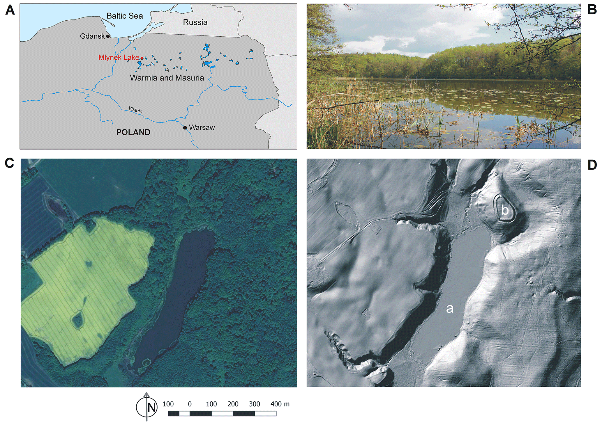
Figure 1(A) Location of Lake Młynek in the Warmia and Mazury Region (north-eastern Poland) (drawing: Fabian Welc). (B) View of Młynek Lake from the north-west (photo: Fabian Welc). (C) Satellite image of the lake (open source: © Google Earth: http://www.google.com/intl/pl/earth, last access: 10 June 2021). (D) Lidar image of the lake: (a) lake basin, (b) Janiki Wielkie archaeological site established in early Iron Age (© Geoportal Poland: http://www.geoportal.gov.pl, last access: 10 June 2021).
Lake Młynek is located near the village of Janiki Wielkie and was selected for multi-faceted palaeoenvironmental research (pollen analysis, diatom, chrysophyte cysts and geochemistry). It is hypothesized that the bottom sediments of this lake contain a unique record of human impact on the surrounding environment, as a result of the location of an Iron Age stronghold on the northern shore, which was active (though not continuously) up until the early Middle Ages (Fig. 1). Due to archaeological research, stratigraphic units distinguished on this site were divided into seven main settlement phases: early Iron Age (I), stronghold abandoned after the early Iron Age (II), early Middle Ages (III), stronghold abandoned in the early Middle Ages (IV), settlement activity in the 11th–13th centuries (V), stronghold definitely abandoned in the 14th century (VI) (Nitychoruk and Welc, 2017; Rabiega et al., 2017).
This study provides an opportunity to reconstruct the transformation of the vegetation around the lake that occurred under the influence of the climate (regional significance) and as a result of human activity. Our results were correlated with geoarchaeological data to determine mutual relations between environmental and climatic changes with development of human settlement phases in the Warmia and Mazury (northern Poland) region during the last 2400 years.
Lake Młynek is a small water body that occupies a glacial tunnel valley since the Holocene. The lake is located in the Iława Lakeland in northern Poland, it is about 720 m long and 165 m wide. The lake has an area of 7.5 ha, with its water level at ∼ 101 m a.s.l., and the maximum depth is just over 2 m. Lake Młynek is surrounded by a morainic plateau at 120–130 m a.s.l, and its catchment is occupied by a dense forest (Fig. 1). In general, most of the Ilawa Lakeland is covered with forest (41.5 %), whereas meadows and synanthropic communities have a smaller share. Among the habitats, a highly productive mixed forest prevails. The basic components of the Iława forest are pine (Pinus), oak (Quercus), beech (Fagus), alder (Alnus) and birch (Betula), and in smaller amounts there are spruce (Picea), larch (Larix), ash (Fraxinus), hornbeam (Carpinus), maple (Acer) and linden (Tilia). Currently, the lake sits in a catchment that is characterized by a transitional climate with an influence from continental and maritime circulation. The growing season lasts about 206 d, and the snow cover remains for 70–90 d. Average temperature values range from approximately −4.0 ∘C in February to above 17.0 ∘C in July. Due to significant influence of the polar air masses and a large number of natural water reservoirs, air humidity is relatively high, ranging from 72 % to 89 %. Total annual precipitation ranges from 500 to 550 mm yr−1. South-western winds dominate throughout the year, with westerly winds stronger in winter and the highest wind speeds recorded during the winter months (Jutrzenka-Trzebiatowski et al., 1997; Stopa-Boryczka at al., 2013). It is important to note that from the north a small stream flows into the lake Młynek, which is active in winter and dries up almost completely in summer (Fig. 1D). The stream is a result of irrigation related to the construction of a mill in the 15th century, somewhere in the vicinity of the medieval stronghold located on the northern shore of the lake (Semrau, 1939; Bińka et al., 2020).
3.1 Bathymetry
The determination of lake bathymetry and thickness of bottom sediments is extremely important in palaeolimnological research to help locate appropriate coring sites. This can be achieved through the use of GPR sounding (Lin et al., 2009; Sambuelli et al., 2009; Sambuelli and Silvia, 2012). In Poland, winter is a particularly convenient season as the lake is covered with ice, making GPR profiling much easier and improving access and the speed of data collection (Hunter et al., 2003). Measurements along and across the lake were carried out in 2017, directly on the lake ice (Fig. 2). We used the radar system ProEx of the Malå Geoscience (http://www.malagpr.com.au/mala-professional-explorer.html, last access: 23 May 2021). A radar pulse was generated at a regular distance interval of 0.02 m (900 samples were recorded from a single pulse). The time window of recording was between 250 and 300 ns. Prospection was done with use of a shielded monostatic antenna with 250 MHz nominal frequency of the electromagnetic wave.

Figure 2GPR reflection profile across Lake Młynek (see Fig. 2): (a) drilling M1, (b) upper boundary of the so-called hard bottom, (c) stratified glaciofluvial sandy-gravel beds beneath the lake sediments, (d) attenuation zone of electromagnetic waves connected with occurrence of organic sediment (gyttja) (measurements, processing and interpretation: Fabian Welc).
3.2 Coring and sampling
Based on the results of the GPR sounding, four drillings were undertaken a ca. 2 m water depth (Fig. 3) following the Givelet et al. (2004) collecting protocol. A piston sampler was used during drilling, which is very suitable for sampling in moderately cohesive sediments to a depth of 5 m. The sampler set consists of a 200 cm long sonde, which is constructed from a thin-walled, 40 mm diameter, stainless steel tube (https://en.eijkelkamp.com/products/sediment-samplers/Piston-Sampler-set.html, last access: 10 June 2021). Sediment cores were film-wrapped in 1 m plastic tubes and transported to the laboratory. The cores (M1 to M4) were then subjected to magnetic susceptibility measurements which enabled the selection of the core M1, the longest and most continuous, to carry out detailed analysis. The 3.5 m long core M1 (geographic coordinates: 53.82486∘ N, 19.72419∘ E) was sub-sampled at 5 cm intervals and used for multi-proxy laboratory analyses.

Figure 3Młynek Lake: location of drillings M1–M4 and transect of GPR sounding (© Google Earth: http://www.google.com/intl/pl/earth).
3.3 Magnetic susceptibility (MS)
The cores from Lake Młynek were subjected to MS measurements using a SM-30 magnetic susceptibility meter (ZH Instruments). Due to very high sensitivity (1 × 10⁻⁷ SI units) this device was provided with an 8 kHz linear integrated circuit oscillator, and its pick-up coil sensor was large enough to measure sufficiently high volume of sediments with very low MS. The measurements were made every 5 cm along each core (M1–M4).
3.4 Radiocarbon dating and age–depth model
Radiocarbon dating was performed on four bulk samples from the core M1, collected either from organic-rich gyttja or gyttja with dispersed organic matter (Table 1). The organic matter seems to have been derived from both aquatic and terrestrial sources. AMS dating was carried out by the Poznań Radiocarbon Laboratory in Poland (for methodology see Goslar et al., 2004). The construction of age–depth models required an assessment of several factors that could disturb constant accumulation of bottom deposits in Lake Młynek, such as those from sedimentary and post-sedimentary processes (including a varied rate of deposition and compaction, and the impact of bioturbation). The varied influx of material delivered to the lake from the adjacent area is a very important factor of disturbance. Therefore, a Bayesian age–depth model was chosen as it takes into account the sedimentation rate and its variability (Blaauw et al., 2007) (Fig. 4). The model was based on default settings, except for section thickness, which was set at 0.05 cm given the length of this core. The Bacon software uses the IntCal3 curve (Reimer et al., 2013) to calibrate the radiocarbon data.
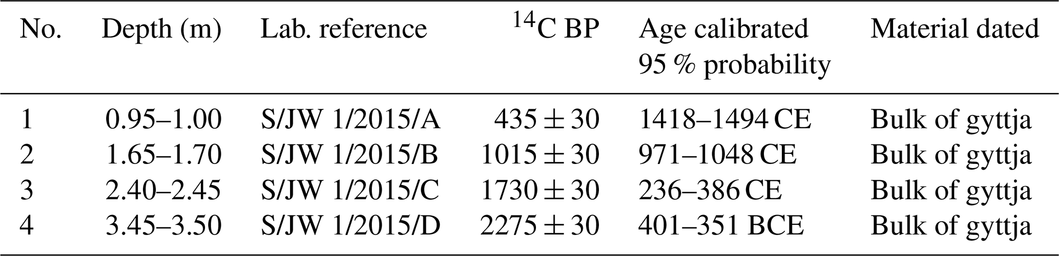
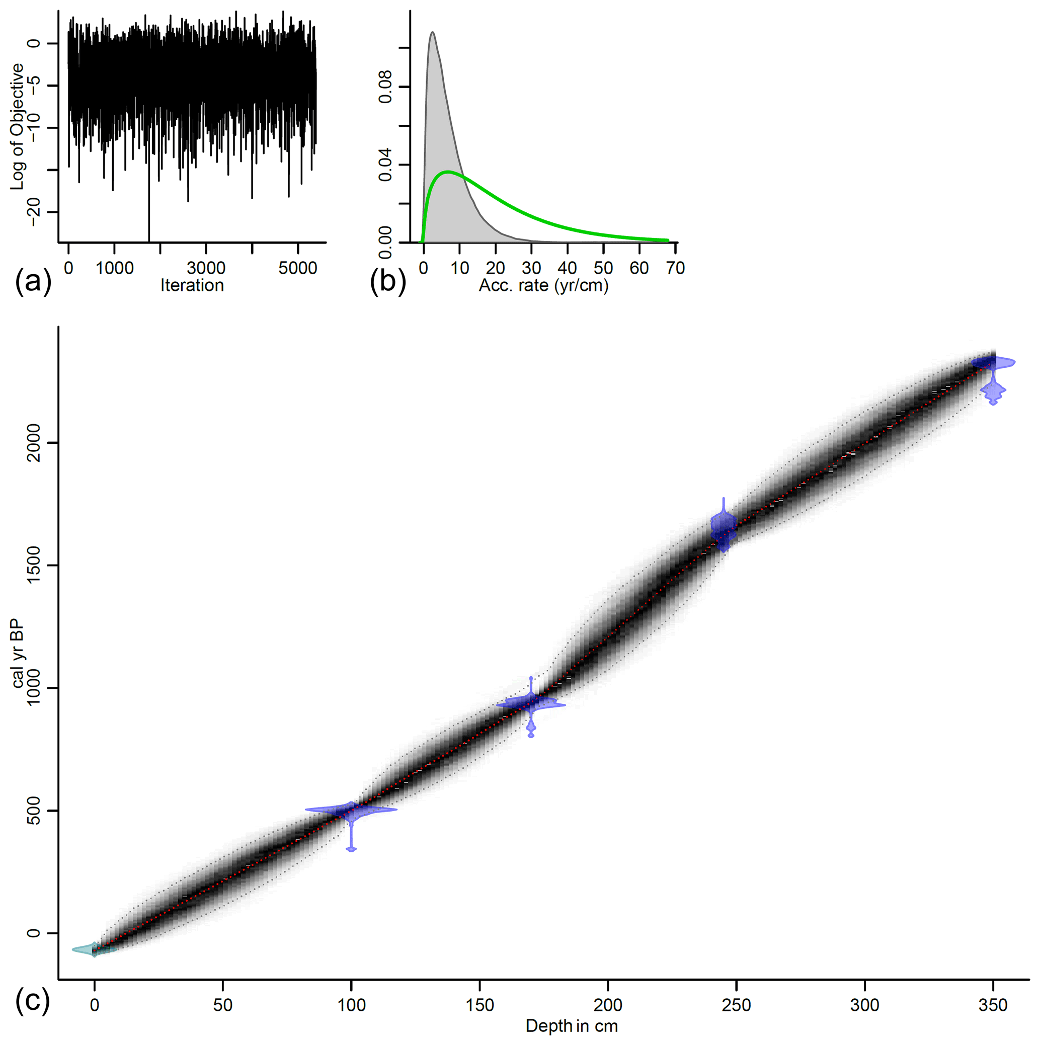
Figure 4Age–depth model of the core M1 from the Lake Młynek sediments. Good runs of a stationary distribution are shown in panel (a); green curves and grey histograms in panel (b) present distributions for the sediment accumulation rate. Panel (c) shows the calibrated 14C dates (transparent blue) and the age–depth model (darker grey areas), which indicate calendar ages. Grey stippled lines show 95 % confidence intervals and the red curve shows the “best” model based on the weighted mean age for each depth. The model was created by Fabian Welc using the open Bacon software (Blaauw and Christen, 2011).
3.5 Palaeobotanical analysis
3.5.1 Pollen
The core M1 was sampled every 5 cm for pollen analysis. A total of 70 samples (ca. 10 g each) were treated with 5 % HCl and boiled in 5 % KOH and hot 30 % Hf. They were washed with 15 % HCl and treated by the standard Erdtman's acetolysis. In each sample about 1000 pollen grains were counted using an optical microscope at 400× magnification.
3.5.2 Diatom and chrysophyte cyst analysis
A total of 70 samples were prepared for the analysis of diatoms and chrysophyte cysts. They were extracted from 1 g of dry sediment of using the disintegration method in HCl and H2O2, according to the technique proposed by Zalat and Vildary (2005). For slide preparation, 0.1 mL of the final suspension was dried on coverslips and then mounted onto slides using Naphrax. Diatoms were identified to species level using a Leica photomicroscope with a digital camera and equipped with differential interference contrast (DIC) optics at 1000× magnification with oil immersion. Identification and ecological information of the diatom species were based primarily upon the published literature (e.g. Kilham et al., 1986; Douglas and Smol, 1999; Witkowski et al., 2000; Hofmann et al., 2011). Recent taxonomic advances split many diatom taxa of the former genus Fragilaria sensu lato into several new genera, including Fragilaria, Pseudostaurosira, Staurosira and Staurosirella spp. (Williams and Round, 1987); these new names are herein collectively referred to as Fragilaria sensu lato. Chrysophyte cysts were described and enumerated following Duff et al. (1995, 1997) and Wilkinson et al. (2002). Preliminary results of the diatom studies based on the core M1 were already published by Zalat et al. (2018).
3.6 Geochemical analysis
ICP-OES (inductively coupled plasma–optical emission spectrometry) was used for determination of basic (Al, Ca, Mg, Na, K, Fe, P) and trace elements (As, Cd, Mn, Th, Ti, U, V, Zn). Powdered samples were mineralized in a closed microwave Anton Paar Multiwave PRO reaction system. The mineralization procedure was based on the procedure of Lacort and Camarero (2004). Characteristics of lake sediments were determined by the extraction method of elements that are soluble in aqua regia (according to European Standard CEN/TC 308/WG 1/TG 1, slightly modified). Dry samples of about 0.2 g weight were transferred to the PTFE vessel and HNO3, and HCL Merck Tracepur® was added. The vessels were placed in a rotor and loaded to a microwave. Finally, the samples were analysed in the Spectro Blue ICP-OES spectrometer at the Regional Research Centre for Environment, Agricultural and Innovative Technologies, Pope John II State School of Higher Education, in Biała Podlaska. A Bernd Kraft Spectro Genesis ICAL solution and VHG SM68-1-500 Element Multi Standard 1 in 5 % HNO3 were used.
Total organic carbon (TOC) analysis was done after sample acidification to remove carbonates in the SHIMADZU SSM 5000A analyser with a solid sample combustion unit. The method was the catalytically aided combustion oxidation at 900 ∘C with pre-acidification and oven temperature 200 ∘C. A measuring range TC was 0.1 to 30 mg carbon. The sample amount was 1 g and aqueous content < 0.5 g, with repeatability at SD ±1 % of the full-scale range (http://www.ssi.shimadzu.com/products/toc-analyzers/ssm-5000a, last access: 10 June 2021).
All selected samples were analysed using a scanning electron microscope (SEM) HITACHI TM3000 with an energy dispersive spectrometer (EDS) SWIFT ED 3000 from Oxford Instruments. The samples were not covered with any conductive material. Magnification range was used 20× to 30 000×. This method was used to perform basic microscopic observations of samples of the core M1 with point determination of their chemical composition of major elements.
4.1 Bathymetry
A georadar transect across the lake reflects both its bathymetry and composition of its bottom (Figs. 2–3). The superficial layer of the transect is represented by lake ice that is ca. 25 cm thick, and although it is almost not visible on radar images due to its thickness being smaller than a vertical resolution of measurements, beneath there are multiple abundant horizontal reflections of energy from the bottom of the ice. Two narrow and vertical zones with small diffraction hyperboles at 23 and 29 m of the transect indicate upward deformation of bottom sediments at the location sites of the sounding core and the core M1 (Fig. 2a). The top of the underlying mineral deposits (so-called hard bottom) is indicated as a distinct downward-deflected reflection surface (Fig. 2b). In the central part of the lake, it occurs at 2.6 m depth (two-way travel time 290 ns) and indicates the top of the Holocene organic sediments. Unfortunately, beneath there is a signal-absorption zone (Fig. 2d), resulting from the fact that most sediments are composed of fine-grained organic material (gyttja). However, the thickness of this layer was determined by drillings to about 5 m. A relief of the lake bottom in the GPR image reflects a cross section of a buried glacial tunnel valley that was eroded mainly in sandy and sandy-gravel deposits. Close to the lake shore (0 to 20 m in the north-west and 110 to 140 m in the south-east), there are numerous oblique and chaotically parallel reflection surfaces dipping towards the channel axis. They reflect bedding of the Pleistocene sandy-gravel series that partly filled a subglacial channel (Fig. 2c).
4.2 Magnetic susceptibility
MS is highly dependent on lithology and grain size of deposits (Dearing, 1994; Sandgren and Snowball, 2001). It reflects the presence and size of ferromagnetic particles in a sample (Verosub and Roberts, 1995). Increased content of ferromagnetic minerals such as magnetite, Fe-Ti oxides or pyrrhotite generates higher MS whereas biotite, pyrite, carbonates and organics result in its lower values. The total volume of magnetic minerals in lake sediments mostly reflects climatic changes in a catchment (Bloemdal and deMenocal, 1989; Snowball, 1993; Peck et al., 1994). MS in the core M1 is varied but due to the organic character of the sediments, its values are relatively low, from 0.002 to 0.034 × 10⁻⁷ units SI. In grey-brown gyttja with organic matter at 3.50–2.58 m depth, MS rises and drops in turn from 0.01 to 0.02 × 10⁻⁷ SI. MS drops from 2.60 m depth, reaching a minimum at 1.63 m. Higher up, MS rises again, with the highest value at 1.35 m; then there is a minimum at 1.05 m, and the next maximum is at 0.69 m depth (Fig. 6).
4.3 Chronology, lithology and sedimentation rate
The age–depth model of the core M1 from Lake Młynek indicates (Fig. 4) that the M1 core chronologically covers the last 2400 years. Bottom deposits of Młynek Lake are organic-rich. The core M1 is composed of grey-brown gyttja at 1.8–3.6 m depth (Fig. 5). At 1.45–1.80 m depth there is grey-brown gyttja detritus, and at 1.10–1.45 m depth algal gyttja is recorded. The uppermost part of the core is composed of grey-brown (depth 0.4–1.1 m) and detritus gyttja (0.0–0.4 m). The sedimentation rate was calculated based on the age–depth model. Results reflect quite a stable sedimentary environment with a general rate of 1.5 mm yr−1. The rate is stable at 3.40–1.77 m depth and equal to ca. 1.5 mm yr−1. It drops to 1 mm and then rises to 1.3–1.8 mm yr−1 at 1.77–0.30 m. At 0.0–0.3 m the sedimentary rate is the highest and equal to ca. 3 mm yr−1 (Fig. 5).
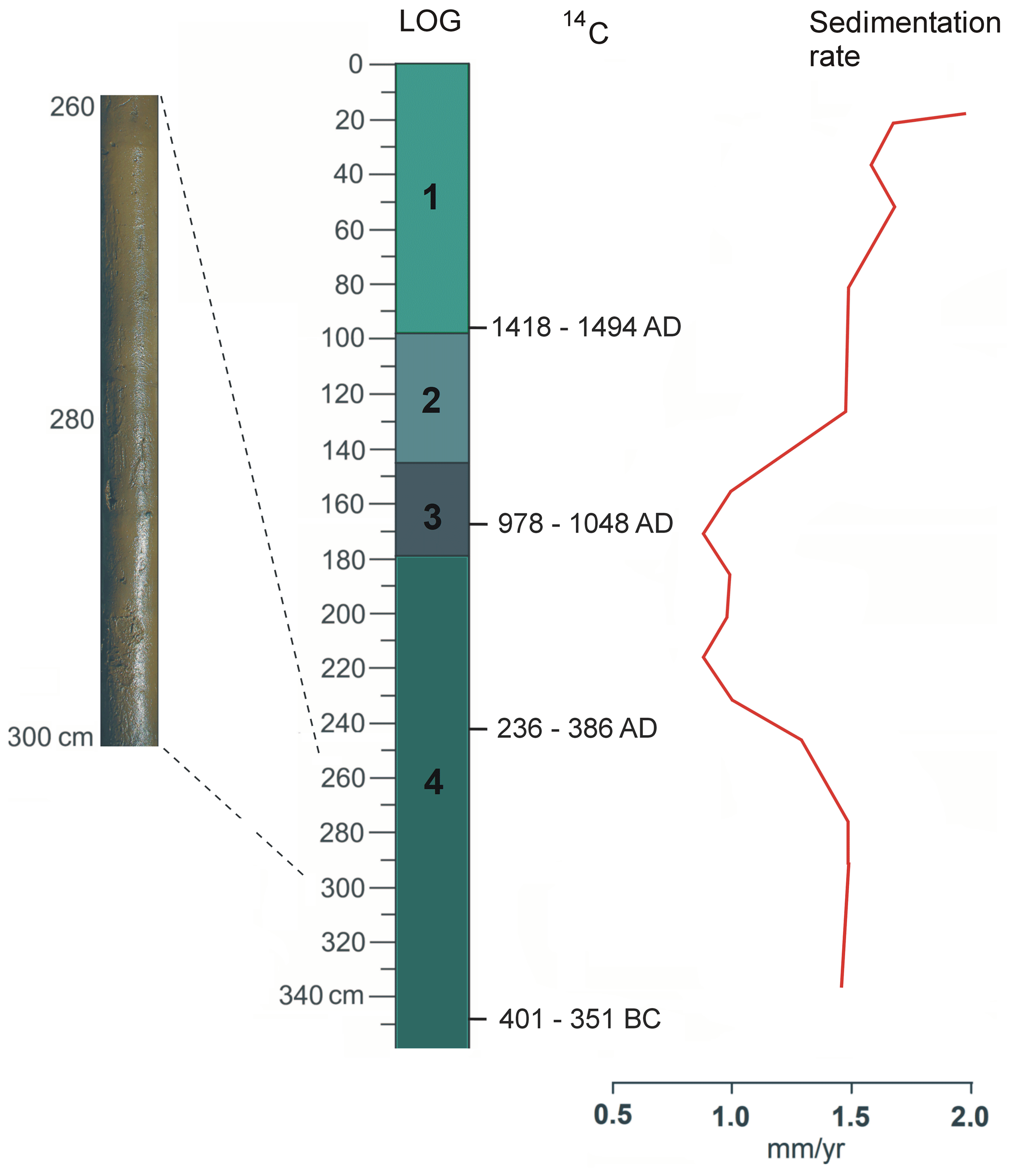
Figure 5Lithology of the M1 borehole with radiocarbon determinations with 95 % confidence, close up – photo of the log at 2.6–3.0 m depth and sedimentary rate (mm yr−1) estimated based on the age–depth model. Description of LOG: 1 – hydrated, detritus-type gyttja; 2 – very plastic, algal gyttja; 3 – grey-brown peaty, detritus gyttja; 4 – grey-brown gyttja (photo and drawing: Fabian Welc).
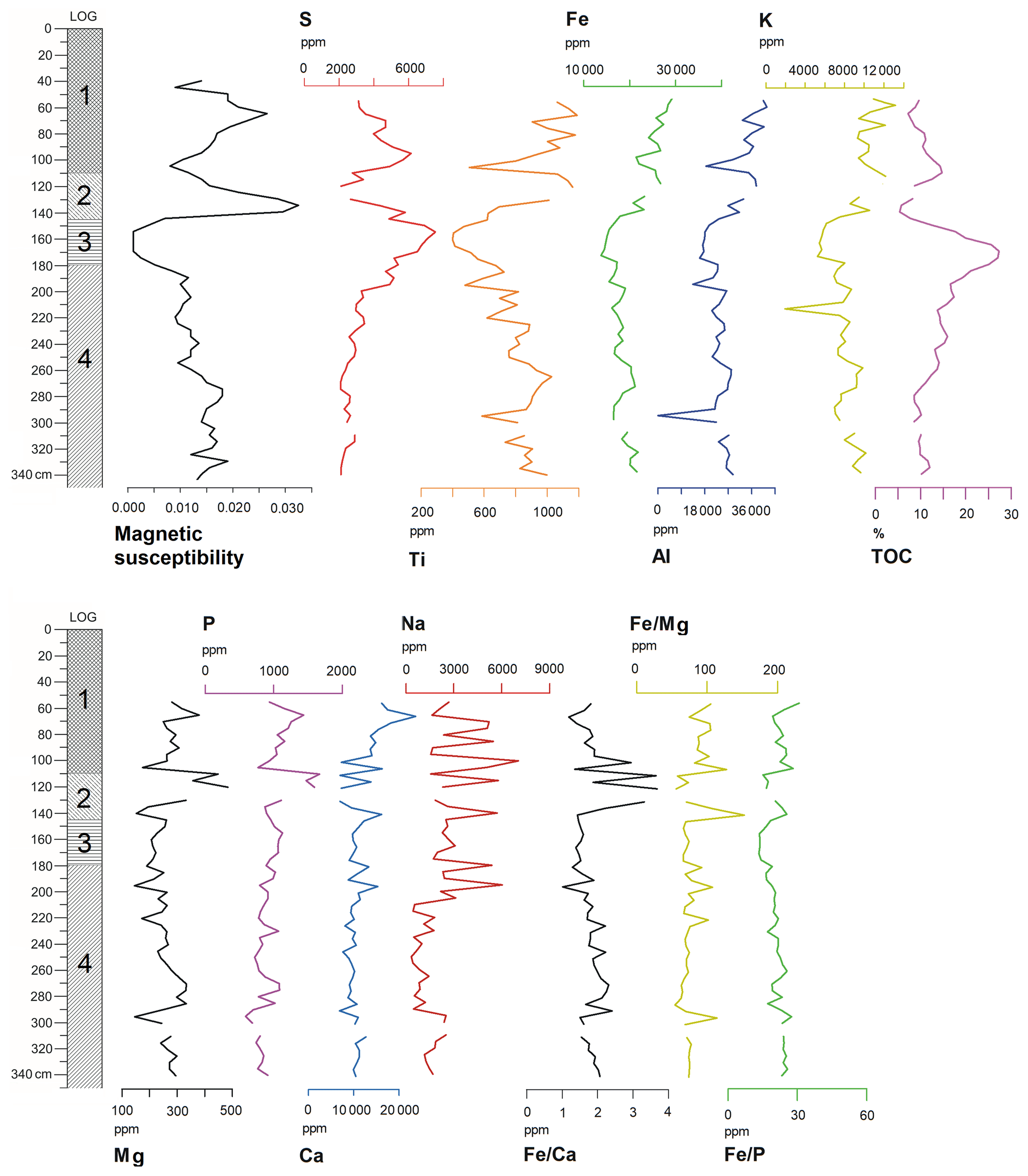
Figure 6Concentration depth curves for selected elements and TOC in the core M1 of Lake Młynek sediments. Description of LOG: 1 – hydrated, detritus-type gyttja; 2 – very plastic, algal gyttja; 3 – grey-brown peaty, detritus gyttja; 4 – grey-brown gyttja (drawing: Fabian Welc).
4.4 Pollen
Based on percentage contents of main trees and terrestrial herbs five local pollen assemblage zones (LPAZ M1-M5) were established in the pollen sequence of the Lake Młynek. The pollen contents were determined based on changes in the percentage of individual taxa, confirmed by a cluster analysis (Table 2, Fig. 9).
Table 2Local pollen assemblage zones of the Lake Młynek.

4.5 Diatoms
Studies of the Lake Młynek bottom sediments revealed the presence of more than 200 diatom taxa belonging to 54 genera (Zalat et al., 2018) (Fig. 8). Diatoms were generally abundant and well to moderately preserved in most samples, although with a mixture of mechanically broken valves, especially in the topmost part of the core. The results of the diatom analysis and relative abundance of the most dominant taxa enabled subdivision of the M1 core section into 11 diatom assemblage zones (Fig. 8) that reflected six phases of lake development (Zalat et al., 2018). Moreover, changes in chrysophyte cysts distributions along with variation in diatom composition could be related to changes in pH, climate and trophic status. Stomatocysts can be used as the index of lake-level changes, habitat availability, metal concentrations and salinity.
4.6 Geochemistry
Various factors influence distribution and accumulation of geochemical elements in lake sediments. Most important are texture, mineral composition, oxidation/reduction state, absorption/desorption and physical transportation processes (Ma et al., 2016). Curves of representative elements are generally used to characterize sedimentary environments. Most analysed elements do not indicate any clear trend with depth in Lake Młynek. The curves of S and TOC show significant increases at 2.0–1.4 m depth that are slightly correlated with decreased Al, Fe, K, Ca, Mg and MS (Fig. 6). Sulfur content is correlated with the existence of iron sulfides. In the studied core, Fe is positively correlated with Al and Ti (Fig. 7). Fe–Ti oxides are noted in SEM (scanning electron microscopy) EDS (energy dispersive spectroscopy) analysis. They are resistant to surface weathering and carry trace elements (Bauer and Velde, 2014). At ca. 3 m, high-frequency peaks of Al, K, Ca, Na, Mg, Fe and S occur (Fig. 6).
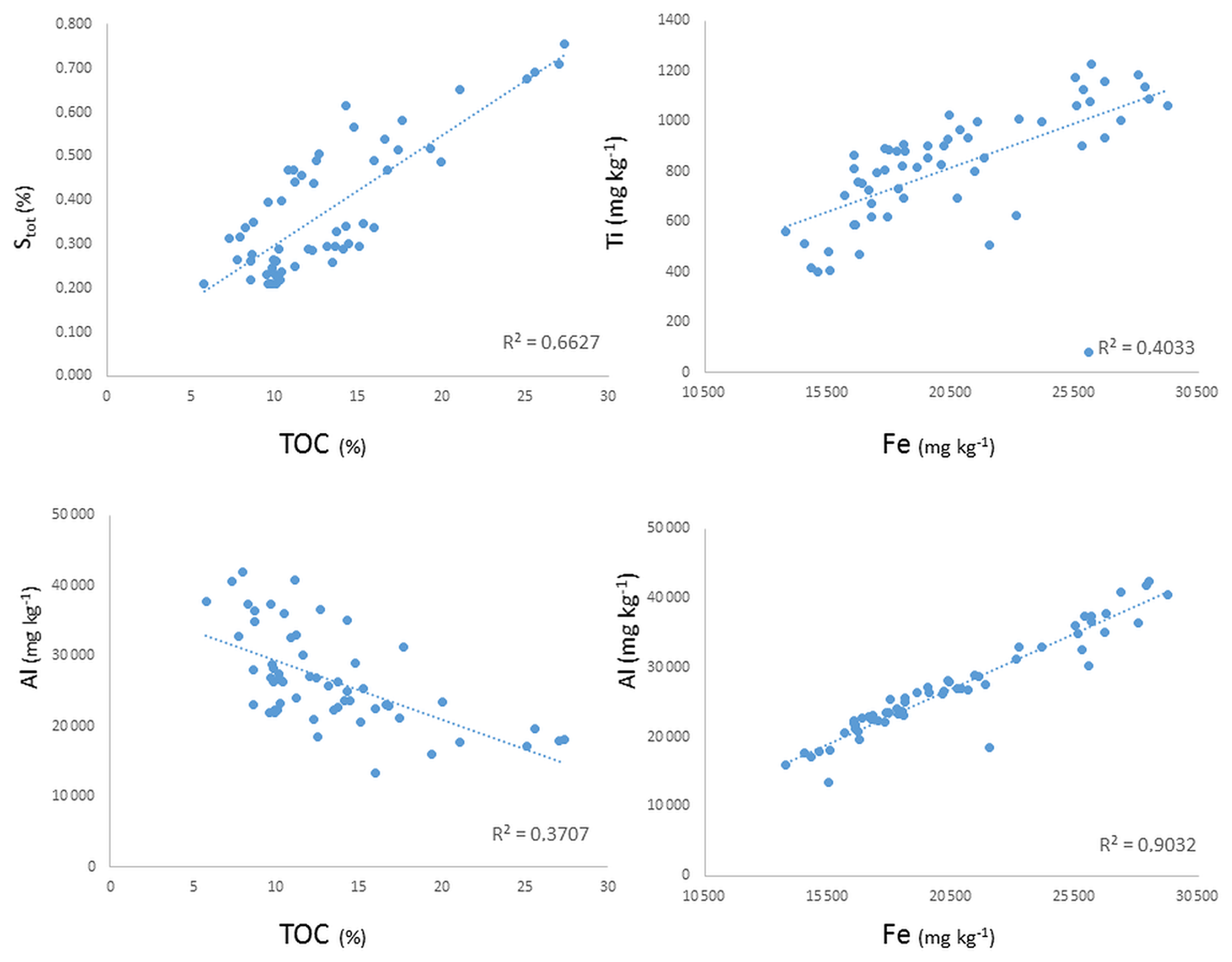
Figure 7Scatter plot showing the correlation in the core M1 between S and TOC, Al and TOC, Ti and Fe, and Ti and Fe (drawing: Anna Rogóż-Matyszczak).
Magnetic susceptibility is generally low in biogenic sediments such as gyttja, which is composed mainly of microfossil skeletons, e.g. diatoms and radiolarians (Thompson and Oldfield, 1986). In Lake Młynek there is an apparent negative relationship between TOC and MS. Several intervals show both higher percentages of TOC and lower MS values. Changes in MS in Lake Młynek sediments most probably record an input of clay into the lake and diagenetic conditions in bottom sediments. Iron oxides are presumably of detrital origin and were delivered to the basin through deep valleys incised at the north-western shore. Concentration of ferromagnetic minerals is connected with periodical intensive soil erosion around the lake. Their higher content also depends on diagenetic processes in bottom sediments. Oxidation of organic matter in anoxic conditions (by iron-oxide-reducing bacteria) results usually in an increase in ferromagnetic particles (small particles are removed first). Conversely, oxygenation by heavy floods stops this process, and small magnetic particles are preserved (Jelinowska et al., 1997). At 1.40 m depth, TOC suddenly drops, probably due to deforestation, and then MS rises significantly due to the increasing input of terrestrial (non-organic) material to the lake. Such a coincidence clearly indicates that TOC is both of autochthonous and allochthonous derivation (Fig. 6).
The highest contents of detrital elements like Al, K, Ca and Mg are to be associated with sudden delivery of clastic material to the lake, e.g. during increased flooding or rainfall (Wirth et al., 2013). Aluminium is extremely immobile, that is why it should be regarded as a typical lithogenic element (Price et al., 2007). Additionally, Al is a major constituent of soils and other sediments as a structural element of clays. It has a strong positive correlation with many major elements (Fig. 7). The association between Al and other elements can be therefore used as the basis to compare natural elemental contents in sediments and soils. Calcium is well correlated with Al and likely originated from terrigenous bicarbonate inputs and deposited in a lake as a solid carbonate (Miko et al., 2003). Calcium is evidently more easily removed in solution from a mineral material and it is highly concentrated in highly erosional periods (Mackereth, 1965).
The Fe Ca ratio is considered as a eutrophication proxy. The highest values are found in low-oxygenation, eutrophic or dystrophic reservoirs (i.e. Kraska and Piotrowicz, 2000; Holmes and De Decker, 2012), whereas the low Fe Ca ratio in bottom sediments indicates the oligotrophic character of a lake. In the studied core sediments, Fe Ca ratio varies from 0.80 (depth 3.05 m) to 3.67 (1.2 m). The ratio is low, indicating oligotrophic conditions in bottom sediments, which gives conflicting results with other data. The Fe Ca ratio can be disturbed by detrital input to the lake (Fig. 6). The dysaerobic conditions in the lake are confirmed by Th U ratios (0.03–0.41) which are lower than the critical value of 2 as indicated by Myers and Wignall (1987). The ratio of total Fe to total P ranges from 13.91 (1.6 m depth) to 30.82 (0.55 m). The values are typical for other lakes in northern Poland, which vary from 3 to 180 according to Bojakowska (2016). The release of P follows in reducing conditions. According to Ahlgren et al. (2011) it can be up to 10 times greater than in aerobic conditions. However, there is a poor correlation with other redox proxies, i.e. Th U (R = 0.08), which may be caused by the presence of Al which forms Al(OH)3. In such systems, even though the redox state favours the release of P from iron minerals, the P is immobilized by binding with hydroxides. Thus, the presence of Al(OH)3 can stop the release of P even in an anoxic hypolimnion (Hupfer and Lewandowski, 2008). This could be the case in the studied sediments as Al shows positive correlation with P content (R = 0.49). Except for Fe Ca, all counted ratios point to anoxic conditions in all studied samples, which is typical in eutrophic lakes. Nevertheless, as all proxies are characterized by extreme values at the 3.05 m depth, they seem to depend on an external load of terrigenous material. It is confirmed with very good positive correlation between Fe and Al (0.95), Fe and Ti (0.64), Mn and Al (0.46), or Mn and Ti (0.78).
The periphytic diatom species dominate throughout the core. A high proportion of periphyton to plankton assemblages was reported as indicative of long-lasting ice cover (Karst-Riddoch et al., 2005), whereas a shift from benthic to planktonic diatom taxa is considered an ecological indicator, which is interpreted in high-altitude lakes as a record of shorter winters and increased temperatures. The common occurrence of benthic forms represented by a Staurosira venter/Staurosirella pinnata diatom assemblage indicates circumneutral to slightly alkaline shallow water with lowering lake levels and prolonged ice cover. However, Aulacoseira is the most dominant planktonic genus followed by Cyclotella and low frequency of Cyclostephanos. Diatom preservation in the upper part of the core (depth 1.40–0.15 m) is moderate to relatively poor, and the recognized assemblage was represented by the occurrence of some dissolved and teratological diatoms valves, in particular the topmost part of the core section (0.30–0.15 m) (Zalat et al., 2018).
Based mostly on the results of palynological studies, five main phases of the Lake Młynek development in relation to the climate and human-induced environmental change were distinguished (Fig. 10).
6.1 Phase 1: 2300–2100 cal BP (ca. 4–1 BCE), depth: 3.45–3.15 m
This phase is recorded in LPAZ M1, which represents closed forest communities dominated by hornbeam and alder, which colonized marshlands near lake shores. Plants of open stands are only rarely noted as well as indicators of anthropogenic activity (e.g. Plantago lanceolata). Vegetation at that time was relatively natural and not disturbed. The diatom assemblage at the start of this record (3.45–3.40 m depth) was distinguished by diatom subzone DZ1a (Fig. 8) dominated by the periphytic taxa such as Staurosira construens, Staurosira venter, Staurosirella pinnata, Gyrosigma acuminatum associated with the planktonic Aulacoseira granulata, A. ambigua and Puncticulata radiosa, which indicates a shallow and slightly alkaline lake. This interval was followed by a great abundance of the planktonic Alkaliphilus diatoms of subzone DZ 1b (3.35–3.15 m, Fig. 8) dominated by Aulacoseira granulata, Cyclotella sensu lato species, Cyclostephanos dubius and Stephanodiscus species. The diatom assemblage suggests a rising lake level with increasing nutrients (Douglas and Smol, 1999; Zalat, 2015). The predominance of A. granulata suggests a high trophic status and slightly alkaline freshwater environment with high silica concentration (Kilham et al., 1986; Zalat et al., 2018). Magnetic susceptibility is high and corresponds to high contents of Fe, Ti and Al, indicating an increasing influx of terrigenous material, presumably activated by intensive rainfall.
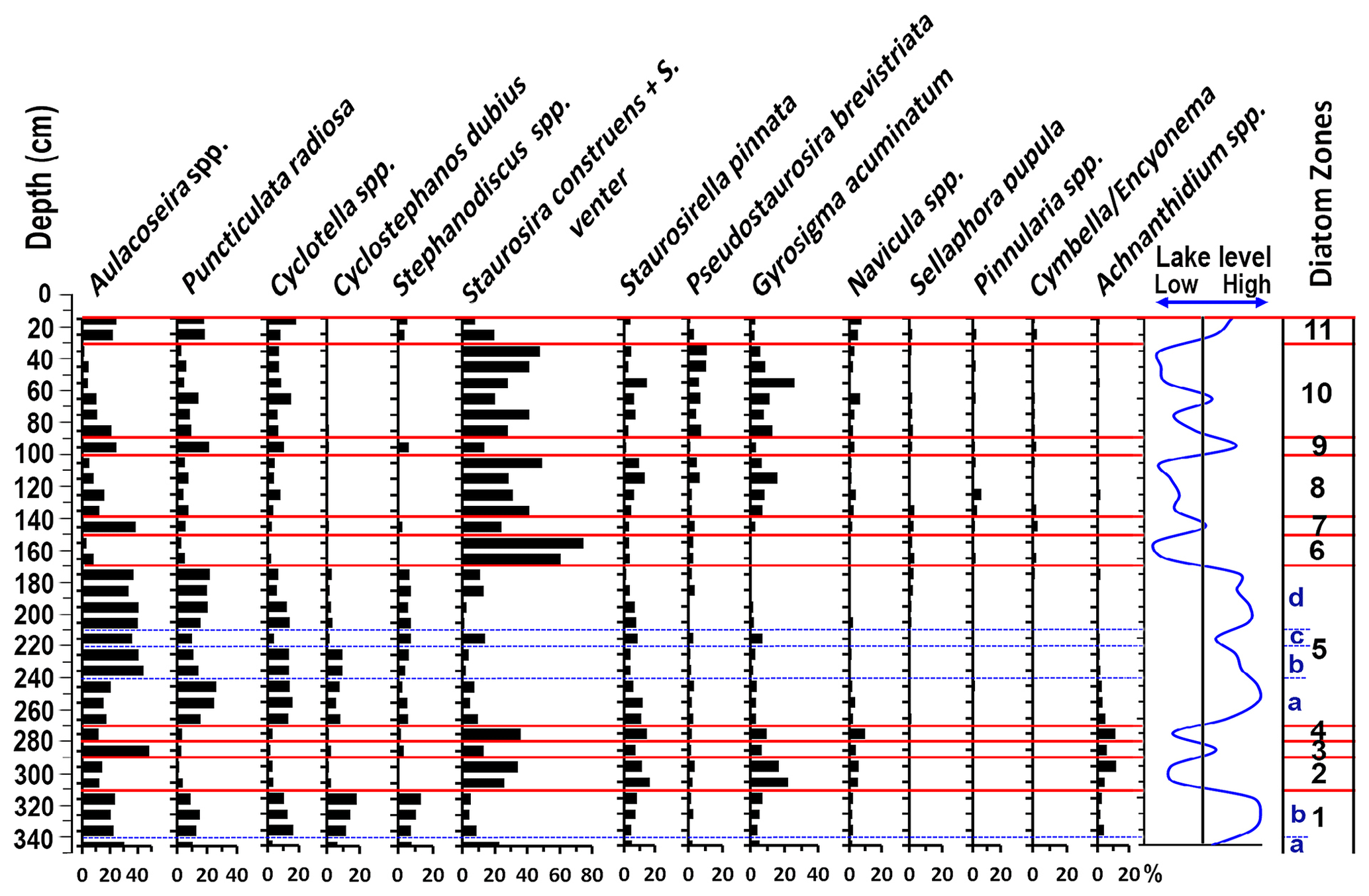
Figure 8Diatom stratigraphy of the core M1, showing diatom zones and lake phases and relative water level changes estimated based on the relation between planktonic and benthonic diatom taxa (interpretation and drawing: Abdelfattah Zalat).
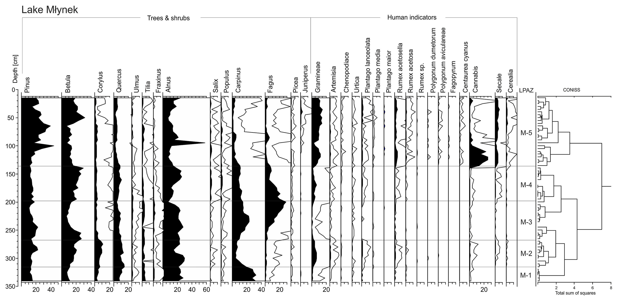

Figure 10Diagram with selected palaeoenvironmental proxies including lithology (1 – hydrated, detritus type gyttja; 2 – very plastic, algal gyttja; 3 – grey-brown peaty, detritus gyttja; 4 – grey-brown gyttja) with phases of human activity in the vicinity of Lake Młynek, supplemented by an archaeological chronology for Poland (drawing: Fabian Welc).
6.2 Phase 2: 2100–1830 cal BP (ca. 1 BCE–2 CE), depth: 3.15–2.65 m
During this phase changes in the environment around the lake were caused by significant human impact. This phase corresponds with the LPAZ M2, characterized by the reduction and fragmentation of the hornbeam-dominated forest. Birch, pine and hazel expanded under better lighting conditions in a partly open forest. Mid-forest pastures occupied rather small-scale open areas, as can be inferred from higher percentages of Plantago lanceolata and other herbaceous plants, e.g. Gramineae, Artemisia and Rumex acetosa/acetosella. Cultivated plants such as Cannabis and Secale are rare; however, their occurrence is entirely consistent with other human indicators present during this phase. This phase is commonly noted and similarly expressed in numerous palynological sequences in neighbouring areas (see for example Noryśkiewicz, 1982, 1987; Bińka et al., 1991; Ralska-Jasiewiczowa et al., 1998). Pollen data indicate that societies of that time cultivated rye and probably hemp. It is the oldest settlement phase at Janiki Wielkie stronghold and corresponds to the termination of the La Tène and the time of the early Roman period. Human communities in the vicinity of the lake can be connected with settlements of the eastern Baltic Kurgan culture (Rabiega et al., 2017). During this phase, planktonic diatoms were replaced by benthic taxa, (DZ2) such as Staurosira construens, S. venter and Staurosirella pinnata accompanied by a significant abundance of Gyrosigma acuminatum indicating a lower lake level and dominance of a mesotrophic alkaline freshwater environment. The lower stands were interrupted by a short rise in water level at 2.90–2.85 m (ca. 1930–1896 cal BP) where the abundance of planktonic eutrophic indicator Aulacoseira spp. increased suddenly at the expense of the benthic taxa. During this phase climatic conditions were still similar to ones in the previous phase, but it was drier than is reflected by shallowing of the lake. This phase can be correlated with the so-called Roman Climatic Optimum (see McCormick et al., 2012).
6.3 Phase 3: 1830–1150 cal BP (ca. 2–9 CE), depth: 2.65–1.95 m
This phase corresponds to LPAZ M3 when a forest restoration occurred. Absence of human indicator plants suggest that the settlement in the catchment was abandoned. There are also no traces of human activity nearby (Rabiega et al., 2017). Reduction of human impact and human-generated semi-open habitats allowed for a short-term expansion of birch into empty, open areas, which were later replaced by hornbeam that rebuilt its position to the level it was at in the LPAZ M1. Elm also expanded again in a riparian forest. This restoration of the natural forest was followed by abrupt expansion of beech in the second half of the LPAZ M3. The area of open herbaceous plants communities, previously widespread, was limited.
Abundant planktonic diatoms including Aulacoseira spp. and Puncticulata radiosa and the common occurrence of small Cyclotella spp. occurred in the lake (Fig. 8), which indicates its deepening, enhanced thermal stratification, reduced mixing and increased thermal stability (Zalat et al., 2018). Intensified development of vegetation cover and higher lake levels are indicated by geochemical indices. A gradual drop of MS corresponds with decreased content of detrital elements such us Fe, Ti, Al and K, accompanied by a gradual increase in TOC and the Fe Ca ratio. Lower MS and Al content (acting as a major constituent of soils) accompanied by the higher TOC suggest limited erosion, in spite of gradually higher precipitation in the lake catchment and therefore a rise in its water level (Fig. 6). The climate in this phase has become more humid. Increased rainfall and decreased evaporation are reflected in lake sedimentation as the lake got deeper, resulting in reduced deposition and greater stability. This phase could be associated with a global cooling of the Bond 1 event (1.5 ka BP) (Bond et al., 1997; Welc, 2019).
6.4 Phase 4: 1150–780 cal BP (ca. 9–13 CE), depth: 1.95–1.45 m
This phase is correlated with the LPAZ M4 and is divided into two sub-phases 4a and 4b (Fig. 10). The sub-phase 4a marks the onset of another settlement phase, resulting in forest clearing. Disturbances took place firstly in a beech forest and less in a hornbeam-dominated one. The anthropogenic activity is reflected by presence of Gramineae, Artemisia, Cannabis/Humulus, Plantago lanceolata, Rumex acetosella, Secale and Cerealia undiff. Diatom assemblages suggest a deepening of the lake (Zalat et al., 2018) as indicated by the abundance of Aulacoseira associated with Puncticulata radiosa in the upper part of the diatom zone 5 at 1.85–1.70 m depth (ca. 1070–941 cal BP). The diatom assemblage suggests a rising lake level, higher trophy and stronger turbulent mixing conditions (Rühland et al., 2008; Zalat et al., 2018). Moreover, the greatest reduction of abundant Fragilaria sensu lato accompanied by abundant A. granulata, could be a result of forest clearing around the lake. Higher TOC corresponds with lower content of detrital material (Fe, Ti, Al and K) and lower MS, and it can reflect a progressing humidity (Fig. 6). This phase can be correlated with the Migration Period and the early Middle Ages. A wooden-loamy defence rampart was raised at the end of the phase in a settlement close to the lake (archaeological phase III), after removal of a natural soil developed during abandonment of the site in the early Roman Period. After a short period, this stronghold was destroyed. Charcoal from a fired wall that represents destruction at the end of the archaeological phase IIIA was dated at 1245 ± 25 cal BP (i.e. 682–870 CE; 95.4 % probability) and 1090 ± 30 cal BP (i.e. 892–1014 CE; 95.4 % probability) (Rabiega et al., 2017).
Human impact declines during the subphase 4b (1.70–1.45 m depth, ca. 940–782 cal BP). At this time birch and less intensively poplar occupied temporarily abandoned open areas, especially toward the end of the zone, when human activity was less intensive. Alder became more abundant, probably expanding into exposed marginal areas of the lake. The sub-phase 4b corresponds to the diatom zone 6 (Fig. 8), which is characterized by abundant benthic Fragilaria sensu lato with sporadic occurrence of planktonic taxa. A high proportion of benthic to plankton assemblages was reported as indicative of long-lasting ice cover (Karst-Riddoch et al., 2005). As well as this, a great abundance of the benthic Staurosira venter and Staurosira construens with marked decline in the planktonic diatoms such as Aulacoseira spp. and Puncticulata radiosa reflects lowering water levels and slightly alkaline freshwater, lower nutrient concentrations and low silica content (Kilham et al., 1986; Stevens et al., 2006; Zalat et al., 2018).
In the stronghold at the lake shore, the next phase of human activity took place at the end of the 11th century CE when a new rampart was raised. Wooden constructions were also built, traces of which were excavated in the gate passage. The settlement was finally abandoned, presumably in the first half of the 13th century, and then its ramparts were strongly eroded, with their material moving towards a yard and the moat (Rabiega et al., 2017). The sub-phase 4b is characterized by a gradual warming, which correlates with a gradual shallowing of the lake and increased rate of sedimentation. Human impact on the environment in this sub-phase is already so great that reconstruction of a climate change is not clear. There is no doubt; however, that this is a warm period, which should be correlated with the Medieval Warm Period (MWP) (Mann et al., 2009).
6.5 Phase 5: 780–0 cal BP (13 CE–present time), depth: 1.45–0 m
This phase starts about 1200 CE and is connected with the early Modern Period. Cultivation and treatment of hemp has been terminated but cultivation of cereals and presence of synanthropic plants indicate human activity near the lake. The water level changes only slightly and is not high, which is evidenced by a great abundance of benthic diatom taxa over the planktonic forms (DZ 8–10, Fig. 8). There is a drop in TOC and rise in MS caused by increasing input of terrestrial material at 1.4 m depth (ca. 751 cal BP), resulting presumably from human deforestation. The small watercourse which enters the lake from the north-east appeared most probably during this phase and had a strong impact on its water environment (see, Bińka et al., 2020). As previously mentioned, in the 15th century CE a mill was built near the lake, and damming of the water in the mill reservoir probably contributed to periodical blooms of dinoflagellate populations in Lake Młynek. Major blooms of Tetraedron, which usually precede blooms of the dinoflagellate, were most probably the main factor that contributed to the decline of settlement at the stronghold (Bińka et al., 2020). This zone is also characterized by increased precipitation which is reflected by more intensive terrestrial inflow to the lake and is confirmed by quasi-linear correlation of MS with contents of Fe and Ti in sediments (Fig. 6). The modern lake is shallow (2–3 m) and gradually overgrowing. Summing up, the phase 5 is marked by intensive human activity around the lake, and therefore most “natural” environmental and climate changes are obliterated.
The above scenario seems to be confirmed by earlier palaeoenvironmental research carried out in the south-western part of the Warmia–Masuria lake lands (Kupryjanowicz, 2008; Kołaczek et al., 2013). Previous studies of the lake sediments in this region were based mainly on pollen analysis and enable the comparison of the Lake Młynek record with other sequences.
The closest records from Lake Woryty (Pawlikowski et al., 1982; Noryśkiewicz and Ralska-Jasiewiczowa, 1989; Ralska-Jasiewiczowa and Latałowa, 1996), just 35 km to the east, is a reference one. Palaeoenvironmental records inferred from the Lake Młynek core are very similar to the Woryty palynological succession with distinctive human impact during the Roman Period and the Medieval Ages, however, a detailed comparison is difficult, because of the low resolution of the pollen spectrum obtained at Woryty.
The second site is Lake Drużno, located in the Vistula Delta, 35 km to the north of Młynek Lake (Zachowicz et al., 1982; Zachowicz and Kępińska, 1987; Miotk-Szpiganowicz et al., 2008). Unfortunately, the low resolution and the lack of reliable age–depth models of the lake make comparison difficult. Despite habitat differences between Lake Drużno and Lake Młynek, pollen records obtained at both sites are very similar and comprise human indicators during the Roman Period and human impact during the Medieval times.
The pollen spectrum from Lake Łańskie (Madeja, 2013), located 55 km to the south-east from Lake Młynek, shows higher pine content and lower share of beech than in the case of Lake Młynek. Such divergences are probably not only due to different location and environmental conditions in the lake vicinity but also depend on different size of these lakes. Lake Młynek is a very small (0.7 km2) mid-forest basin, whereas Lake Łańskie is over 10 km2 large and contains mostly a regional pollen record. Based on periodical appearances of human plant indicators and archaeological data between 300 BCE and 800 CE, three human phases of the West Baltic Barrow, Wielbark and Prussian cultures were distinguished (Madeja, 2013). In the pollen diagram from Lake Młynek (phase 2), the first culture is indicated, including termination of the La Tène and the Roman Period. Significant growth of human indicators from the beginning of the 11th century CE, are visible in diagrams from both sites. A more local record from Lake Młynek is especially marked by high Humulus/Cannabis content (to 25 %) in the 13th–15th centuries CE. In the sediments of Lake Łańskie, hemp occurred discontinuously and was < 1 %.
The pollen records from Lake Młynek are similar to the ones from the Masurian lakes, Wojnowo, Miłkowskie and Jędzelek, located over 100 km to the east (Wacnik et al., 2014). Recorded episodes of human impact on vegetation during the Roman Period and Medieval times are separated by 500–600-year-long intervals without cultivation and with natural reforestation (indicated by a strong presence of birch, which is a pioneer species). A similar period of human withdrawal in the Lake Młynek section began and terminated earlier than recorded in the lakes Wojnowo and Miłkowskie. Another history of human activity is represented in a record from Lake Salęt (Szal et al., 2014b). Pollen grains of cultivated and ruderal plants are noted continuously from the early Iron Age to the early Medieval times. In contrast to the pollen record from lakes Młynek, Wojnowo and Miłkowskie, the suggested continuous settlement in the neighbourhood of the Lake Salęt was interrupted by a single very short decline of human impact between 880–980 CE (Szal et al., 2014a). Numerous pollen data are available from the area adjacent in the south-west in the Brodnica Lake District, including Strażym Lake (Noryśkiewicz, 1987; Noryśkiewicz and Ralska-Jasiewiczowa, 1989), Oleczno Lake (Filbrandt-Czaja, 1999; Filbrandt-Czaja et al., 2003) and the Chełmno Lakeland (Noryśkiewicz, 2013). Pollen records from this region also suggest intensive settlements during La Tène, Roman and Medieval periods.
Pollen records from other sites located to the east of Lake Młynek indicate differences in the representation of beech content. The Fagus sylvatica content changes to the north-east, and its significantly high content in Lake Młynek sediments represents a very local record in a small lake. The decline of Fagus sylvatica depends on a continental climate and is noted in pollen diagrams from the lakes Salęt (Szal et al., 2014a), Mikołajki (Ralska-Jasiewiczowa, 1989), Żabińskie (Wacnik et al., 2016) and Wigry (Kupryjanowicz, 2007). A decline of beech is accompanied by a rise in Picea abies. A record of human activity in pollen spectra from eastern Poland was noted at many sites.
Based on the results of laboratory analysis, supplemented with archaeological data, five main environmental phases of the Lake Młynek development were distinguished (Fig. 10). Radiocarbon ages enabled detailed chronology, whereas pollen data and stratigraphy of the stronghold to the north-east of the lake made correlation possible between human activity for the last 2300 years and environmental data. From the first century BCE to second century CE the forest around the lake was much reduced, which can be associated with pre-Roman and Roman occupation phases (confirmed also by the stronghold located close to the lake). From the second to ninth century CE there is a gradual restoration of the forest and decline in human activity along with a deepening of the lake as a result of wetter climatic conditions. This colder and humid phase corresponded to the Bond 1 event (1.5 ka BP) cooling episode. Intensive forest clearing around the lake occurred in the 9th–13th centuries CE as result of another phase of human activity. This period is marked by warming, confirmed by a gradual shallowing of the lake (Middle Age Warm Period). Since the 14th century CE strong human impact transformed the local landscape, especially through the construction and activity associated with the mill and the creation of a small artificial lake in the 15th century CE. This results in potential climate-driven environmental changes being obscured by the direct impact of humans on the lake and its catchment. It is important to add here that transformations of Lake Młynek, reconstructed based on diatom analysis, not only indicate changes of the lake water level and correspond with a human impact but also determine episodes of more humid climate during coolings.
We can conclude that environmental transformations recorded in bottom lake sediments of Lake Młynek were highly dependent on human activity and were especially intensive in the Roman and Middle Age periods due to favourable climatic conditions
All data will be made available on request.
FW, JN, and LM conceptualized the study. FW, JN, KB, ARM, MO, and AZ designed the methodology. Formal analysis was performed by FW, JN, LM, KB, ARM, MO, and AZ. The investigation was carried out by FW and JN. FW and JN provided resources and wrote the original draft. FW, JN, and LM reviewed and edited the paper. Visualization was carried out by FW, KB, ARM, MO, and AZ. JN and FW acquired the funds.
The authors declare that they have no conflict of interest.
The research was funded by the National Science Centre in Poland in the project UMO-2016/21/B/ST10/03059: “Correlation of prehistoric and early medieval settlement phases in north-east Poland with the changes of the natural environment in the light of lacustrine sediments study”.
This research has been supported by the National Science Centre in Poland – Narodowe Centrum Nauki (grant no. UMO-2016/21/B/ST10/03059).
This paper was edited by Keely Mills and reviewed by Daniel Schillereff and one anonymous referee.
Ahlgren, J., Reitzel, K., De Brabandere, H., Gogoll, A., and Rydin, E.: Release of organic P forms from lake sediments, Water Res., 45, 565–572, 2011.
Bauer, A. and Velde, B.: Geochemistry at the Earth's Surface Movement of Chemical Elements, Springer-Verlag, Berlin, Heidelberg, Germany, 2014.
Bińka, K., Cieśla, A., Łącka, B., Madeyska, T., Marciniak, B., Szeroczyńska, K., and Więckowski, K.: The development of Błędowo Lake (Central Poland) – A palaeoecological study, Stud. Geol. Polon., 100, 1–83, 1991.
Bińka, K., Welc, F., Nitychoruk, J., Sieradz, D., and Lewczuk, A: Unique finds in palynological spectra: acetolyze resistant vegetative forms of freshwater dinofagellate based on the Lake Młynek record from northeastern Poland, Studia Quaternaria, 37, 59–67, 2020.
Blaauw, M. and Christen, J. A.: Flexible Palaeoclimate Age-Depth Models Using an Autoregressive Gamma Process, Bayesian Anal., 6, 457–474, 2011.
Blaauw, M., Christen, J. A., Mauquoy, D., van der Plicht, J., and Bennett, K. D.: Testing the timing of radiocarbon dated events between proxy archives, Holocene, 17, 283–288, 2007.
Bloemdal, J. and deMenocal, P.: Evidence for a change in the periodicity of tropical climate cycles at 2.4 Myr from whole-core magnetic susceptibility measurements, Nature, 342, 897–900, 1989.
Bojakowska, I.: Phosphorous in lake sediments of Poland – results of monitoring research, Limnological Review, 16, 15–25, 2016.
Bond, G., Showers, W., Cheseby, M., Lotti, R., Almasi, P., Demenocal, P., Priore, P., Cullen, H., Hajdas, I., and Bonani, G.: A pervasive millennial-scale cycle in North Atlantic holocene and glacial climates, Science, 278, 1257–1266, 1997.
Brauer, A.: Annually laminated lake sediments and their palaeoclimatic relevance, in: The Climate in Historical Times, Towards a Synthesis of Holocene Proxy Data and Climate Models, GKSS School of Environmental Research, edited by: Fischer, H., Kumke, T., Lohmann, G., Flöser, G., Miller, H., von Storch, H., and Negendank, J. F. W., Springer-Verlag, Berlin, Germany, 111–129, 2004.
Brauer, A., Dulski, P., Mangili, C., Mingram, J., and Liu, J.: The potential of varves in high-resolution palaeolimnological studies, PAGES News, 17, 96–98, 2009.
Cooke, G. D., Welch, E. B., Peterson, S., and Nichols, S. A.: Restoration and Management of Lakes and Reservoirs, CRC Press, Boca Raton, USA, 2005.
Czymzik, M., Dulski, P., Plessen, B., von Grafenstein, U., Naumann, R., and Brauer, A.: A 450-year record of spring-summer flood layers in annually laminated sediments from Lake Ammersee (southern Germany), Water Resour. Res., 46, W11528, https://doi.org/10.1029/2009WR008360, 2010.
Dearing, J. A.: Environmental magnetic susceptibility: using the Bartington MS2, Chi Publishing, Keniloworth, UK, 1994.
Douglas, M. S. V. and Smol, J. P.: Freshwater diatoms as indicators of environmental change in the High Arctic, in: The Diatoms: Applications for the Environmental and Earth Sciences, edited by: Stoermer, E. F. and Smol, J. P., Cambridge University Press, Cambridge, UK, 227–244, 1999.
Duff, K. E., Zeeb, B. A., and Smol, J. P.: Atlas of Chrysophycean Cysts, 2. Kluwer Academic Publishers, Dordecht, the Netherlands, Boston, Massachusetts, USA, London, UK, 1995.
Duff, K. E., Zeeb, B. A., and Smol, J. P.: Chrysophyte cyst biogeographical and ecological distributions: a synthesis, J. Biogeogr., 24, 791–812, 1997.
Elbert, J., Grosjean, M., von Gunten, L., Urrutia, R., Fischer, D., Wartenburger, R., Ariztegui, D., Fujak, M., and Hamann, Y.: Quantitative high-resolution winter (JJA) precipitation reconstruction from varved sediments of Lago Plomo 47∘ S, Patagonian Andes, AD 1530–2001, Holocene, 22, 465–474, 2012.
Filbrandt-Czaja, A.: Zmiany szaty roślinnej okolic jeziora Oleczno w późnym holocenie pod wpływem czynników naturalnych i antropogenicznych, in: Studia nad osadnictwem średniowiecznym ziemi chełmińskiej 3, edited by: Chudziak, W., Uniwersytet Mikołaja Kopernika (UMK), Toruń, Poland, 61–68, 1999.
Filbrandt-Czaja, A., Noryśkiewicz, B., and Piernik, A.: Intensification gradient of settlement processes in pollen diagrams from Dobrzyńsko-Olsztyńskie Lake District, Ecological Questions, 3, 125–137, 2003.
Francus, P., von Suchodoletz, H., Dietze, M., Donner, R. V., Bouchard, F., Roy, A.-J., Fagot, M., Verschuren, D., and Kröopelin, S.: Varved sediments of Lake Yoa (Ounianga Kebir, Chad) reveal progressive drying of the Sahara during the last 6100 years, Sedimentology, 60, 911–934, 2013.
Gałązka, D.: Szczegółowa mapa geologiczna Polski 1 : 50 000, ark. Iława (210) [Detailed Geological Map of Poland, scale 1 : 50 000], Iława sheet (210), Centr. Arch. Geol. Państw. Inst. Geol., Warsaw, Poland, 2009.
Givelet, N., Le Roux, G., Cheburkin, A., Chen, B., Frank, J., Goodsite, M. E., Kempter, H., Krachler, M., Noernberg, T., Rausch, N., Rheinberger, S., Roos-Barraclough, F., Sapkota, A., Scholzb, C., and Shotyk, W.: Suggested protocol for collecting, handling and preparing peat cores and peat samples for physical, chemical, mineralogical and isotopic analyses, J. Environ. Monitor., 6, 481–492, 2004.
Goslar, T., Czernik, J., and Goslar, E.: Low-energy 14C AMS in Poznan radiocarbon Laboratory, Poland, Nucl. Instrum. Meth. B, 223–224, 5–11, 2004.
Hofmann, G., Werum, M., and Lange-Bertalot, H.: Diatomeen im Süßwasser-Benthos von Mitteleuropa, A. R. G. GantnerVerlag, Rugell, Liechtenstein, 908 pp., 2011.
Holmes, J. A. and De Decker, P.: The chemical composition of ostracod shells: application in Quaternary paleoclimatology, in: Ostracoda as proxies for Quaternary climate change, Developments in Quaternary Science, edited by: Horne, D., Holmes, J. A., Rodriguez-Lazaro, J., and Viehberg, F., Elsevier, Amsterdam, the Netherlands, 131–140, 2012.
Hunter, L. E., Delaney, A. J., Lawson, D. E., and Davis, L.: Downhole GPR for high-resolution analysis of material properties near Fairbanks, Alaska, in: Ground Penetrating Radar in Sediments, Geological Society, Special Publications, London, UK, edited by: Bristow, C. S. and Jol, H. M., 275–285, 2003.
Hupfer, M. and Lewandowski, J.: Oxygen Controls the Phosphorus Release from Lake Sediments – a Long-Lasting Paradigm in Limnology, Int. Rev. Hydrobiol., 93/4–5, 415–432, 2008.
Jelinowska, A., Tucholka, P., and Wieckowski, K.: Magnetic properties of sediments in a Polish lake: evidence of a relation between the rock-magnetic record and environmental changes in Late Pleistocene and Holocene sediments, Geophys. J. Int., 129, 727–736, 1997.
Jutrzenka-Trzebiatowski, A., Czesław, H., and Benon, P.: Roślinność rzeczywista parku krajobrazowego Pojezierza Iławskiego. Olsztyn. Akad. Rol.-Techniczna. Kat. Bot., Wyd. Zespół Parków Krajobrazowych w Jerzwałdzie, 1997.
Karst-Riddoch, T. L., Pisaric, M. F. J., and Smol, J. P.: Diatom responses to 20th century climate-related environmental changes in high elevation mountain lakes of the northern Canadian Cordillera, J. Paleolimnol., 33, 265–282, 2005.
Kilham, P., Kilham, S. S., and Hecky, R. E.: Hypothesized resource relationships among African planktonic diatoms, Limnol. Oceanogr., 31, 1169–1181, 1986.
Kołaczek, P., Kuprjanowicz, M., Karpińska-Kołaczek, M., Szal, M., Winter, H., Danel, W., Pochocka-Szwarc, K., and Stachowicz-Rybka, R.: The Late Glacial and Holocene development of vegetation in the area of a fossil lake in the Skaliska Basin (north-eastern Poland) inferred from pollen analysis and radiocarbon dating, Acta Palaeobotanica, 53, 23–52, 2013.
Kondracki, J.: Geografia regionalna Polski, Wydawnictwo Naukowe PWN, Warsaw, Poland, 2002.
Kraska, M. and Piotrowicz, R.: Lobelia lakes: specificity, trophy, vegetation and protection, in: protection of beds and wetlands of Pomerania region 3, edited by: Malinowski, B., Sorus, Poznań, Poland, 48–52, 2000.
Kupryjanowicz, M.: Postglacial development of vegetation in the vicinity of the Wigry Lake, Geochronometria, 27, 53–66, 2007.
Kuprjanowicz, M.: Badania palinologiczne w Polsce północno-wschodniej, in: Człowiek i jego środowisko (Polska północno-wschodnia w holocenie), Botanical Guidebooks, edited by: Wacnik, A. and Madeyska, E., W. Szafer Institute of Botany, Polish Academy of Sciences, Warsaw, Poland, 77–95, 2008.
Lin, Y. T., Schuettpelz, C. C., Wu, C. H., and Fratta, D.: A combined acoustic and electromagnetic wave-based techniques for bathymetry and subbottom profiling in shallow waters, J. Appl. Geophys., 68, 203–218, 2009.
Ma, L., Wu, J., Abuduwaili, L., and Liu, W.: Geochemical Responses to Anthropogenic and Natural Influences in Ebinur Lake Sediments of Arid Northwest China, Plos One, 13, e0155819, https://doi.org/10.1371/journal.pone.0155819, 2016.
Mackereth, F. J. H.: Chemical investigations of lake sediments and their interpretation, Proc. R. Soc. London B, 161, 295–309, 1965.
Madeja, J.: Vegetation changes and human activity around Lake Łańskie (Olsztyn Lake District, NE Poland) from the mid Holocene, based on palynological study, Acta Palaeobotanica, 53, 235–261, 2013.
Mann, M. E., Zhang, Z., Rutherford, S., Bradley, R. S., Hughes, M. K., Shindell, D., Ammann, C., Faluvegi, G., and Ni, F.: Global Signatures and Dynamical Origins of the Little Ice Age and Medieval Climate Anomaly, Science, 326, 1256–1260, 2009.
McCormick, M., Büntgen, U., Cane, M. A., Cook, E. R., Harper, K., Huybers, P., Litt, T., Manning, S. W., Mayewski, P. A., More, A. F. M., Nicolussi, K., and Tegel, W.: Climate Change during and after the Roman Empire: Reconstructing the Past from Scientific and Historical Evidence, J. Interdiscipl. Hist., 43, 169–220, https://doi.org/10.1162/JINH_a_00379, 2012.
Miko, S., Durn, G., Adamcová, R., Čović, M., Dubíková, M., Skalský, R., Kapelj, S., and Ottner, F.: Heavy metal distribution in karst soils from Croatia and Slovakia, Environ. Geol., 45, 262–272, 2003.
Miotk-Szpiganowicz, G., Zachowicz, J., and Uścinowicz, S.: Review and reinterpretation of the pollen and diatom data from the deposits of the Southern Baltic lagoons, Polish Geological Institute Special Papers, Warsaw, Poland, 45–70, 2008.
Myers, K. J. and Wignall, P.: Understanding Jurassic Organic-rich Mudrocks – New Concepts using Gamma-ray Spectrometry and Palaeoecology: Examples from the Kimmeridge Clay of Dorset and the Jet Rock of Yorkshire, in: Marine Clastic Sedimentology, edited by: Legett, J. K. and Zauffa, G., Graham and Trotman, Bath, UK, 172–189, 1987.
Nitychoruk, J. and Welc, F.: Janiki Wielkie, Środowisko fizyczno-geograficzne, in: Katalog Grodzisk Warmii i Mazur, edited by: Kobyliński, Z., Fundacja Res Publica Multiethnica, Warsaw, Poland, 153–155, 2017.
Noryśkiewicz, A. M.: Historia roślinności i osadnictwa Ziemi Chełmińskiej w późnym holocenie, Studium palinologiczne, Wydawnictwo Naukowe Uniwersytetu Mikołaja Kopernika, Toruń, Poland, 266 pp., 2013.
Noryśkiewicz, B.: Lake Steklin – a reference site for the Dobrzyń-Chełmno Lake District, N Poland, Report on palaeoecological studies for the IGCP-Project No. 158B, Acta Palaeobotanica, 22, 65–83, 1982.
Noryśkiewicz, B.: History of vegetation during the Late-Glacial and Holocene in Brodnica Lake District in light of pollen analysis of Lake Strażym deposits, Acta Palaeobotanica, 27, 283–304, 1987.
Noryśkiewicz, B. and Ralska-Jasiewiczowa, M.: Type region P-w: Dobrzyń-Olsztyn lake District, Acta Palaeobotanica, 29, 85–93, 1989.
Ojala, A. E. K., Kosonen, E., Weckström, J., Korkonen, S., and Korhola, A.: Seasonal formation of clastic-biogenic varves: the potential for palaeoenvironmental interpretations, GFF-Special issue: Varve Genesis Chronol. Paleoclimate, 135, 237–247, 2013.
Pawlikowski, M., Ralska-Jasiewiczowa, M., Schönborn, W., Stupnicka, E., and Szeroczyńska, K.: Woryty near Gietrzwałd, Olsztyn Lake District, NE Poland – history and lake development during the last 12 000 years, Acta Palaeobotanica, 22, 85–116, 1982.
Peck, J. A., King, J. W., Colman, S. M., and Kravchinsky, V. A.: A rock magnetic record from lake Baikal, Syberia: Evidence for Late Quaternary climate change, Earth Planet. Sc. Lett., 122, 221–238, 1994.
Price, S. J., Howe, R. W., Hanowski, J. M., Regal, R. R., Niemi, G. J., and Smith, C. R.: Are anurans of Great Lakes coastal wetlands reliable indicators of ecological condition, J. Great Lakes Res., 33, 3211–3223, 2007.
Rabiega, K., Rutyna, M., and Wach, D.: Janiki Wielkie, Badania Archeologiczne, w: Katalog Grodzisk Warmii i Mazur, Warsaw, edited by: Kobyliński, Z., Fundacja Res Publica Multiethnica, Warsaw, Poland, 155–174, 2017.
Ralska-Jasiewiczowa, M.: Type region P-x: Masurian Great Lake Dystrykt, Acta Palaeobotanica, 29, 95–100, 1989.
Ralska-Jasiewiczowa, M. and Latałowa, A.: Poland, in: Palaeoecological events during the Last 15 000 years: Regional Synthesis of Palaeoecological Studies of Lakes and Mires in Europe, edited by: Berglund, B. E., Birks, H. J. B., Ralska-Jasiewiczowa, M., and Wright, H. E., John Wiley & Sons, Chichester, UK, 403–472, 1996.
Ralska-Jasiewiczowa, M., Goslar, T., Madeyska, T., and Starkel, L.: Lake Gościąż, Central Poland, a monographic study, W. Szafer Institute of Botany, Polish Academy of Sciences, Krakow, Poland, 1998.
Reimer, P. J., Bard, E., Bayliss, A., Beck, J. W., Blackwell, P. G., Bronk Ramsey, C., Buck, C. E., Edwards, R. L., Friedrich, M., Grootes, P. M., Guilderson, T. P., Haflidason, H., Hajdas, I., Hatté, C., Heaton, T. J., Hogg, A. G., Hughen, K. A., Kaiser, K. F., Kromer, B., Manning, S. W., Reimer, R. W., Richards, D. A., Scott, E. M., Southon, J. R., Turney, C. S. M., and van der Plicht, J.: Selection and treatment of data for radiocarbon calibration: an update to the International Calibration (IntCal) criteria, Radiocarbon, 55, 1923–1945, 2013.
Rühland, K., Paterson, A. M., and Smol, J. P.: Hemispheric-scale patterns of climate-related shifts in planktonic diatoms from North American and European lakes, Global Change Biol., 14, 2740–2754, 2008.
Sambuelli, L. and Silvia, S.: Case study: A GPR survey on a morainic lake in northern Italy for bathymetry, water volume and sediment characterization, J. Appl. Geophys., 81, 48–56, 2012.
Sambuelli, L., Calzoni, C., and Pesenti, M.: Case history: Waterborne GPR survey for estimation bottom-sediment variability: A survey on the Po River, Turin, Italy, Geophysics, 74, 95–102, 2009.
Sandgren, P. and Snowball, I.: Application of mineral magnetic techniques to Paleolimnology, in: Tracking environmental change using lake sediments, Physical and geochemical methods 2, edited by: Last, W. and Smol, J., Kluwer Academic Publishers, Dordrecht, the Netherlands, 2001.
Semrau, A.: Mitteilungen des Coppernicus-Vereins für Wissenschaft und Kunst zu Thorn, Heft 42, Elbing, Prussia, 1939.
Smol, J. P., Birks, J. B., and Last, W. M.: Tracking Environmental Change Using Lake Sediments, Terrestrial, Algal and Siliceous Indicators, Springer-Verlag, Berlin, Germany, 371 pp., 2001.
Snowball, I.: Mineral magnetic properties of Holocne lake sediments and soils form the Karsa Valley, Lappland, Sweden, and their relevance to paleoenvironmental reconstruction, Terra Nova, 5, 258–270, 1993.
Stankevica, K., Kalnina, L., Klavins, M., Cerina, A., Ustupe, L., and Kaup, E.: Reconstruction of the Holocene Palaeoenvironmental Conditions Accordingly to the Multiproxy Sedimentary Records from Lake Pilvelis, Latvia, Quatern. Int., 386, 102–115, 2015.
Stevens, L. R., Stone, J. R., Campbell, J., and Fritz, S. C.: A 2200-yr record of hydrologic variability from Foy Lake, Montana, USA, inferred from diatom and geochemical data, Quaternary Res., 65, 264–274, 2006
Stopa-Boryczka, M., Boryczka, J., Wawer, J., Grabowska, K., Dobrowolska, M., Osowiec, M., Błażek, E., Skrzypczuk, J., and Grzęda, M.: Climate of north-eastern Poland based on J. Kondracki and J. Ostrowski's Physiographic division, Atlas of interdependence of meteorological and geographical parameters in Poland, Warsaw University, Warsaw, Poland, 2013.
Szal, M., Kupryjanowicz, M., and Wyczółkowski, M.: Late Holocene changes in vegetation of the Mrągowo Lakeland (NE Poland) as registered in the pollen record from Lake Salęt, Studia Quaternaria, 31, 51–60, 2014a.
Szal, M., Kupryjanowicz, M., Wyczółkowski, M., and Tylmann, W.: The Iron Age in the Mrągowo Lake District, Masuria, NE Poland: the Salęt settlement microregion as an example of long-lasting human impact on vegetation, Veg. Hist. Archaeobot., 23, 419–437, 2014b.
Thompson, R. and Oldfield, F.: Environmental magnetism, Allen and Unwin, London, UK, 1986.
Tiljander, M., Ojala, A. E. K., Saarinen, T., and Snowball, I.: Documentation of the physical properties of annually laminated (varved) sediments at a sub-annual to decadal resolution for environmental interpretation, Quatern. Int., 88, 5–12, 2002.
Tylmann, W., Szpakowska, K., Ohlendorf, C., Woszczyk, M., and Zolitschka, B.: Conditions for deposition of annually laminated sediments in small meromictic lakes: a case study of Lake Suminko (northern Poland), J. Paleolimnol., 47, 55–70, 2012.
Valpola, S. E. and Ojala, A. E. K.: Post-glacial sedimentation rate and patterns in six lakes of the Kokemöaenjoki upper watercourse, Finland, Boreal Environ. Res., 11, 195–211, 2006.
Verosub, K. L. and Roberts, A. P.: Environmental Magnetism: past, present and future, J. Geophys. Res., 100, 2175–2192, 1995.
Wacnik, A., Kupryjanowicz, M., Mueller-Bieniek, A., Karczewski, M., and Cywa, K.: The environmental and cultural contexts of the late Iron Age and medieval settlement in the Mazurian Lake District, NE Poland: combined palaeobotanical and archaeological data, Veg. Hist. Archaeobot., 23, 439–459, 2014.
Wacnik, A., Tylmann, W., Bonk, A., Goslar, T., Enters, D., Meyer-Jacob, C., and Grosjean, M.: Determining the responses of vegetation to natural processes and human impacts in north-eastern Poland during the last millennium: Combined pollen, geochemical and historical data, Veg. Hist. Archaeobot., 25, 479–498, https://doi.org/10.1007/s00334-016-0565-z, 2016.
Wanner, H., Beer, J., Bütikofer, J., Crowley, T. J., Cubasch, U., Flückiger, J., Goosse, H., Grosjean, M., Joos, F., Kaplan, J. O, Küttel, M., Müller, S. A., Prentice, I. C., Solomina, O., Stocker, T. F., Tarasov, P., Wagner, M., and Widmann, M.: Mid- to Late Holocene climate change: an overview, Quat. Sci. Rev., 27, 791–1828, 2008.
Welc, F.: Lake sediments and geoarchaeology (editorial), Studia Quaternaria, 34, 3–8, 2017.
Welc, F.: Geoarchaeological evidence of late and post-Antiquity (5th–9th c. AD) climate changes recorded at the Roman site in Plemići Bay (Zadar region, Croatia), Studia Quaternaria, 36, 3–17, 2019.
Wetzel, R. G. (Ed.): Past productivity: paleolimnology, in: Limnology, Lake and River Ecosystems, edn. 3, Elsevier, Oxford, UK, 785–804, 2001.
Wilkinson, A. N., Zeeb, B. A., and Smol, J. P.: Atlas of chrysophycean cysts, Kluwer Academic Publishers, Dordecht, The Netherlands, 2002.
Williams, D. M. and Round, F. E.: Revision of the genus Fragilaria, Diatom Res., 2, 267–288, 1987.
Wirth, S. B., Gilli, A., Niemann, H., Dahl, T. W., Ravasi, D., Sax, N., Hamann, Y., Peduzzi, R., Peduzzi, S., Tonolla, M., Lehmann, M. F., and Anselmetti, F. S.: Combining sedimentological, trace metal (Mn, Mo) and molecular evidence for reconstructing past water-column redox conditions: the example of meromictic Lake Cadagno (Swiss Alps), Geochim. Cosmochim. Ac., 120, 220–238, 2013.
Witkowski, A., Lange-Bertalot, H., and Metzeltin, D.: Diatom flora of marine coasts I, in: Iconographia diatomologica: annotated diatom micrographs, edited by: Lange-Bertalot, H., A. R. G. Gantner Verlag, Liechtenstein, Germany, 1–925, 2000.
Zachowicz, J. and Kępińska, U.: The palaeoecological development of Lake Drużno (Vistula Deltaic Area), Acta Palaeobotanica, 27, 227–249, 1987.
Zachowicz, J., Przybyłowska-Lange, W., and Nagler, J.: The Late-glacial and Holocene vegetational history of the Żulawy region, N Poland, A. Biostratigraphic study of Lake Drużno sediments, Acta Palaeobotanica, 22, 141–161, 1982.
Zalat, A. A.: Holocene diatom assemblages and their palaeoenvironmental interpretations in Fayoum Depression, Western Desert, Egypt, Quatern. Int., 369, 86–98, 2015.
Zalat, A. A. and Vildary, S. S.: Distribution of diatom assemblages and their relationship to environmental variables in the surface sediments of three northern Egyptian lakes, J. Paleolimnol., 34, 159–174, 2005.
Zalat, A. A., Welc, F., Nitychoruk, J., Marsk, L., Chodyka, M., and Zbucki, Ł.: Last two millennia water level changes of the Młynek Lake (Northern Poland) inferred from diatoms and chrysophyte cysts record, Studia Quaternaria, 35, 77–89, 2018.
Zolitschka, B.: Varved lake sediments, in: Encyclopaedia of Quaternary Science, edited by: Elias, S. A., Elsevier, Amsterdam, the Netherlands, 3105–3114, 2007.