the Creative Commons Attribution 4.0 License.
the Creative Commons Attribution 4.0 License.
 | 10 Mar 2026
Contrasting early- and late-Holocene vegetation and wildfire regimes in a high-value drinking water supply area, Canada
Daniel R. Horrelt
Kendrick J. Brown
Nicholas Conder
John A. Trofymow
Christopher Bone
Paleoenvironmental reconstructions of past ecosystems and fire regimes can strengthen interpretations of modelled future fire environments. In this study, sediment cores from four lakes in a high-value municipal water supply area are used to compare climate, vegetation, and fire along a regional east-west precipitation gradient, contrasting warm-dry early- and cool-moist late-Holocene conditions. Results indicate that inferred precipitation was lower in the past, with more open-canopy xeric Pseudotsuga menziesii (Douglas-fir) forests compared to present-day closed-canopy mesic Tsuga heterophylla (western hemlock) and Thuja (cedar) forests. Overall, the wettest and western-most site experienced the greatest change through time, with more frequent early-Holocene fires yielding to longer fire return intervals in the late-Holocene. This implies that northern coastal temperate rain shadow forests, currently experiencing little fire, may become more vulnerable to increased fire disturbance in the future. It also highlights susceptibility to fire regime shifts consistent with regional observations and models suggesting current and future increases in extreme fire disturbance.
- Article
(8392 KB) - Full-text XML
- BibTeX
- EndNote


The works published in this journal are distributed under the Creative Commons Attribution 4.0 License. This license does not affect the Crown copyright work, which is re-usable under the Open Government Licence (OGL). The Creative Commons Attribution 4.0 License and the OGL are interoperable and do not conflict with, reduce or limit each other. The co-authors Daniel R. Horrelt, Kendrick J. Brown, Nicholas Conder, and John A. Trofymow are employees of the Canadian Government and therefore claim Crown copyright for the respective contributions.
© Crown copyright 2026
Climate change is driving an increase in global wildfire activity with significant economic, social, and environmental consequences (Liu et al., 2010; Wang et al., 2024; MacCarthy et al., 2024; Bowman et al., 2017; Mattioli et al., 2022; Clarke et al., 2023; Chen et al., 2024; Burton et al., 2024). Temperate coniferous forests, typically located in coastal and mountainous regions and characterized by cool-wet winters and warm-dry summers, are not exempt. Over the last 2 decades, these forests experienced a disproportionate abundance of extreme fire events and are forecast to see a further 25 % increase in conditions conducive to fire by the end of the century (Senande-Rivera et al., 2022; Cunningham et al., 2024). In western North America, area burned and frequency of large fires are increasing, with models forecasting more extreme fire weather over the coming decades (Flannigan et al., 2005; Westerling et al., 2006; Wang et al., 2015, 2016b, 2017; Hanes et al., 2019). For example, the 2023 wildfire season in the Canadian province of British Columbia (BC), was the worst on record. Within BC, an estimated 2.84 million hectares (ha) burned, multiple lives were lost, and approximately CAD 817 million was spent on wildfire suppression (BC Wildfire Service, 2024). The implications are profound, highlighting the need for greater insight into the processes influencing these changes.
To a large extent, the linkages between climate and fire systems are well established (Overpeck et al., 1990; Agee, 1993; Whitlock et al., 2003; Power et al., 2008; Marlon et al., 2009; Fischer et al., 2015), but the uncertainty produced by global climate models (GCM) and climate-fire non-stationarity complicates analyses of forest response to future projected warming (Moritz et al., 2012; Knutti and Sedláček, 2013; Littell, 2018; Parisien et al., 2019; Dye et al., 2024). While predictive models offer key insights into wildfire risk and climate adaptation, they are limited by incomplete historical fire data, lack of fire records, and the impact of land management practices such as fire exclusion (Westerling et al., 2006; Moritz et al., 2014; Hessburg et al., 2019). Furthermore, northern temperate forests often exhibit mixed-severity fire regimes and have highly variable fire return intervals (FRI) with multiple intrinsic and extrinsic drivers of disturbance (Agee, 2005; Halofsky et al., 2018). In BC coastal forests, FRIs convey high spatial variability in the region, ranging from < 100 years on drier eastern sites (Pellatt et al., 2015) to longer intervals (> 1000 years) reported at sites in wetter settings (Brown and Hebda, 2002b; Gavin et al., 2003b). Despite these complexities, climate envelope modelling and fire simulations are producing a growing consensus that tests long held assumptions, namely that while fire activity in coastal BC was historically limited by climate, ignition potential, and vegetation structure, recent notable wildfire seasons (i.e. 2017, 2018, 2021 and 2023) reflect a fire regime in transition (Parisien et al., 2023). It is no longer valid to assert that moist temperate forests in the Pacific region of North America are less susceptible to fire disturbance (Wang et al., 2017; Dye et al., 2024), This raises new questions about the significance of shifting fire regimes in areas previously overlooked.
Paleoecological investigations help elucidate these issues by improving understanding of long-term shifts in climate and fire activity, contributing to the strength of interpretation and validation of models (Marlon et al., 2009; Marlon, 2020; Brown et al., 2018, 2019, 2022, 2025). Specifically, pollen sequences offer insights into vegetation and climate, while charcoal records are used to reconstruct past fire regimes, extending insights beyond the comparatively short period of observed and satellite records (Brown and Power, 2013; Chevalier et al., 2020). Although the past does not provide a direct analogue for the future, it reveals how ecological systems and processes change in response to various drivers. For example, the early-Holocene interval is characterized as a comparatively warm climatic phase (Wanner et al., 2008; Renssen et al., 2012; Nakagawa et al., 2021). With ongoing greenhouse gas emissions and climate warming, it represents a climate state that may resemble current or near future fire regime projections, thus making it an important period to investigate. Indeed, the early-Holocene (ca. 7000–11 700 cal yr BP) interval in coastal BC was warmer and drier compared to present (Mathewes and Heusser, 1981; COHMAP Members, 1988; Hebda, 1995; Rosenberg et al., 2004; Brown et al., 2006). The expansion of shade intolerant Douglas-fir (Pseudotsuga menziesii (Mirb.) Franco) after 11700 cal yr BP, together with grasses (Poaceae), roses (Rosaceae), and bracken ferns (Pteridium), implies that open canopy forest prevailed, likely in response to both climate and frequent fire disturbance (Cwynar, 1987; Brown et al., 2008; Lucas and Lacourse, 2013). Prevailing low streamflow, as a proxy for fire season length, suggests that fire seasons were likely of longer duration (Brown and Schoups, 2015; Brown et al., 2019, 2025). In contrast, over the last 4000 years, comparatively cooler and moister climatic conditions prevailed, facilitating establishment of modern temperate forests.
This study compares two distinct climate intervals (early- and late-Holocene) using lake sediment cores extracted from four sites located in the northern temperate rain shadow forests of a high-value municipal drinking water supply area on Vancouver Island, BC, Canada. The objectives are to (1) examine changes in vegetation and fire disturbance across a regional east-west climatic gradient and (2) evaluate how fire regimes changed through time to determine if the past can provide insights into contemporary and future fire activity. Given that wildfire threatens the provision of drinking water for a substantial population in the area (ca. 430 000 people), the persistent-long term effects of forest and fire regime change is of interest to regional water purveyors. The general applicability of this research within similar contexts will have universal appeal for practitioners developing wildfire risk reduction and adaptation strategies.
Study setting
The Greater Victoria Water Supply Area (GVWSA) occupies 20 549 ha of forested land on southern Vancouver Island (48.4 to 48.6° N; −123.5 to −123.9° W; Fig. 1). It is composed of three watersheds (Goldstream, Sooke, and Leech) that are managed by the Capital Regional District (CRD), a regional government for 13 municipalities, and protected by controlled access. Drinking water is largely sourced from the Sooke Lake Reservoir, with minimal treatment (CRD, 2022). Local climate is strongly influenced by proximity to the ocean and mountainous topography, where regular wet frontal low pressure systems in winter are punctuated by persistent warm-dry conditions in the summer from blocking highs (Demarchi, 2011). Regarding vegetation, BC uses a nested zonal system of biogeoclimatic ecological classification (BEC; Meidinger and Pojar, 1991), in which the forests within the watersheds are classified as Coastal Western Hemlock (CWH). Two main BEC subzones are delineated by the east-west precipitation gradient, with CWHxm (xeric maritime) in the drier east and CWHmm (moist maritime) in the moister west (Table 1; Fig. 1). East of the water supply area, another BEC zone, Coastal Douglas-fir (CDF), occupies the driest climate niche on Vancouver Island. A distinction in fire regime characteristics between these zones and subzones provides the rationale behind study site selection, with higher fire frequency occurring in the CDF and longer FRIs with more variability in CWH (Brown and Hebda, 2002b; Gavin et al., 2003a; Wong et al., 2004).
Table 1Characteristics of study lakes within the Greater Victoria Water Supply Area (GVWSA). Location and coordinates, elevation above sea level (a.s.l.), mean annual precipitation (MAP) from Climate BC (Wang et al., 2016a), lake area, lake depth, biogeoclimatic ecological classification (BEC) subzones (BC Forest Analysis and Inventory Branch, 2024), and dominant vegetation.
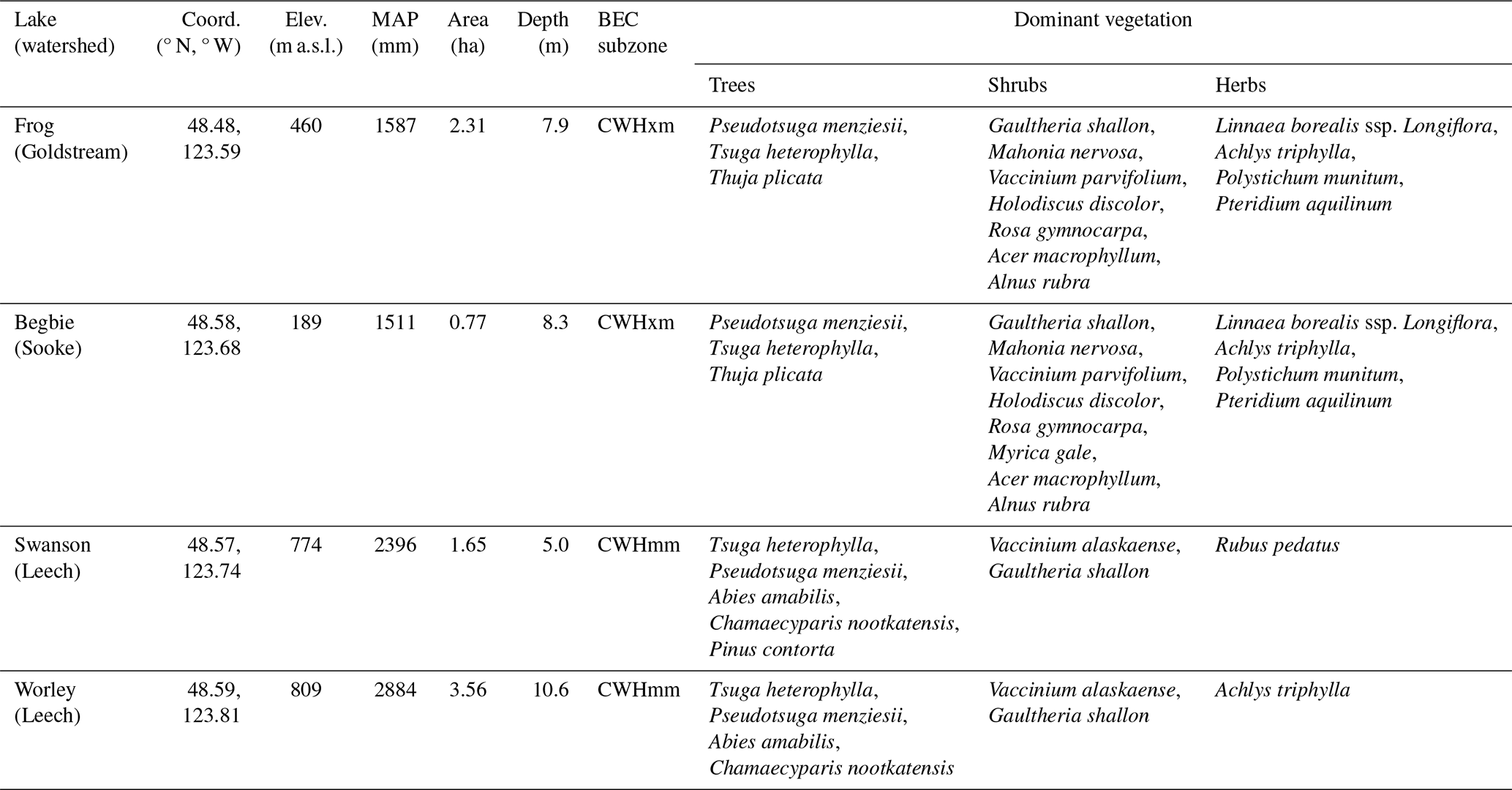
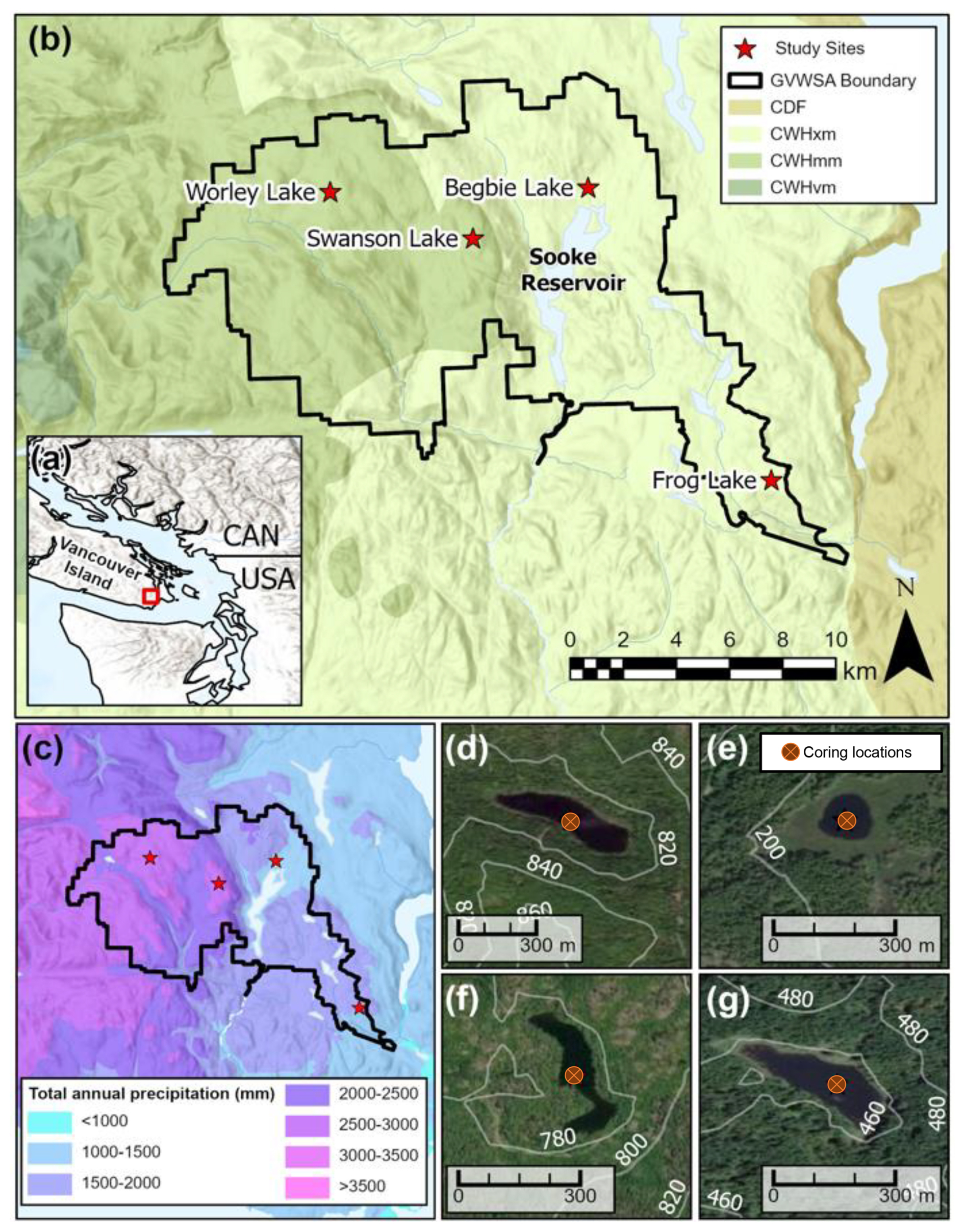
Figure 1Study area map of the Greater Victoria Water Supply Area (GVWSA). (a) Regional overview and study area (inset red box) with world hill shade topography (Esri, 2024a: Esri, Maxar, Airbus DS, USGS, NGA, NASA, CGIAR, N Robinson, NCEAS, NLS, OS, NMA, Geodatastyrelsen, Rijkswaterstaat, GSA, Geoland, FEMA, Intermap, and the GIS user community | Powered by Esri). (b) The GVWSA with site locations and biogeoclimatic ecological classification (BEC) zones and subzones (BC Forest Analysis and Inventory Branch, 2024). (c) Average total annual precipitation, 1991–2020 (Wang et al., 2016a). (d–g) Worley Lake, Begbie Lake, Swanson Lake, and Frog Lake respectively, showing coring locations, surrounding topography (20 m contours, white lines) and scale (0–300 m), world imagery (Esri, 2024b: Esri, Maxar, Earthstar Geographics, and the GIS User Community | Powered by Esri).
Four sites were selected for study within the GVWSA based on their contrasting biogeoclimatic conditions (Table 1). Frog Lake is the southeastern most study site and represents the driest and warmest climate (CWHxm), with the surrounding topography distinguished by south-southwestern aspects, steep rocky bluffs below the site, and hummocky terrain above. Begbie Lake, also in CWHxm, is the lowest elevation site, with the basin having the smallest surface area of all sites investigated. It is located just north of the main Sooke Lake Reservoir. At this site, the topography is generally flat with a marginal wetland around the lake giving rise to a hill with dominant southeastern aspects above the site. Swanson and Worley lakes lie within the moist CWHmm subzone. Swanson Lake is the shallowest lake studied and sits just inside the Leech watershed near the western boundary of the Sooke where it represents the most eastern extent of CWHmm. The site occurs on top of a prominent undulating ridge. A few small craggy features protrude above the site providing both north and southwest facing local aspects. The ridge slopes steeply down from the site to the north and east. Worley Lake is the western most site, as well as the largest and deepest lake. The site sits on a bench surrounded by gentle, hummocky terrain and local topography that reflects both north and south aspects.
Sediment cores were recovered from the deepest part of each lake basin. Upper unconsolidated sediment was recovered using a 50 cm long Kajak corer (Kajak et al., 1965), whereas a Livingstone piston corer (Wright, 1967; Livingstone, 1955) was used to retrieve deeper sediment in 1 m increments. To establish chronologies, bulk sediment samples and plant macrofossils were sent to the University of Ottawa A.E. Lalonde AMS Laboratory for radiometric (14C) age determination (Table 2). Radiocarbon ages were calibrated to calendar years using OxCal v4.4 (Ramsey, 2009) and the IntCal20 calibration curve (Reimer et al., 2020). A volcanic ash layer, consisting of glass shards when viewed under a compound microscope, was observed in all cores. Given its stratigraphic location relative to other radiocarbon dates coupled with the known distributions of regional ash plumes, it is likely to be Mazama ash (Egan et al., 2015). The age-depth model was established using the Bacon package for R (V 4.1.1), which uses a Bayesian approach to estimate accumulation rates from radiocarbon dates through Markov Chain Monte Carlo (MCMC) iterations (Blaauw and Christen, 2011). Given that Mazama ash is an instantaneous event, its thickness was omitted from modelling. Priors for the accumulation rate were modelled using a gamma distribution, with memory (autocorrelation) defined using a beta distribution (Fig. 2). Default parameters (Goring et al., 2012) were applied to all models except Worley Lake where the acc.shape was decreased to reduce the peakedness of the prior distribution and produce a better fit.
Table 2Chronological control points and modelled ages for study sites in the Greater Victoria Water Supply Area (GVWSA).
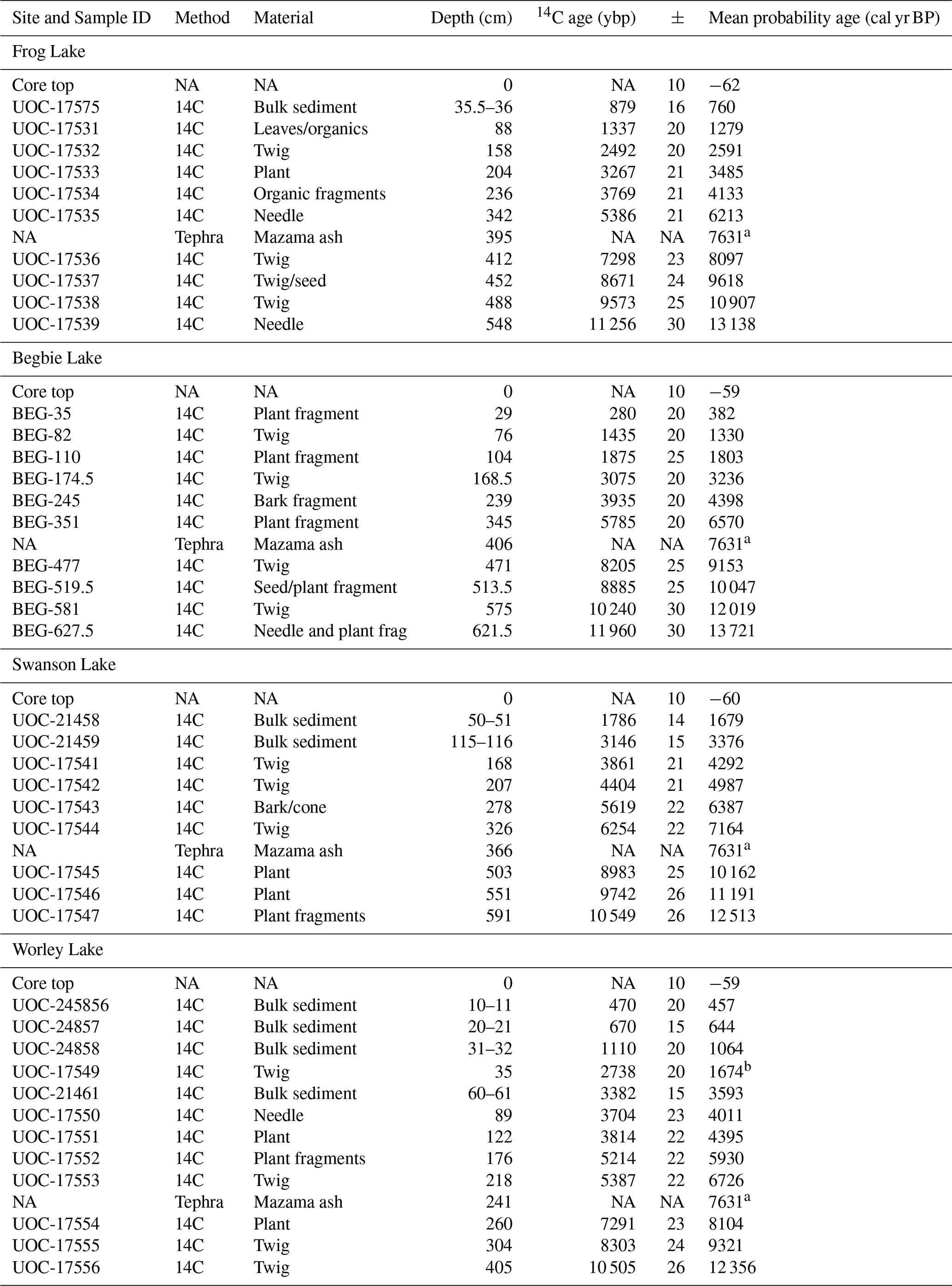
NA: not available. a Modelled age from Egan et al. (2015). b Sample modelled outside the 95 % confidence interval.
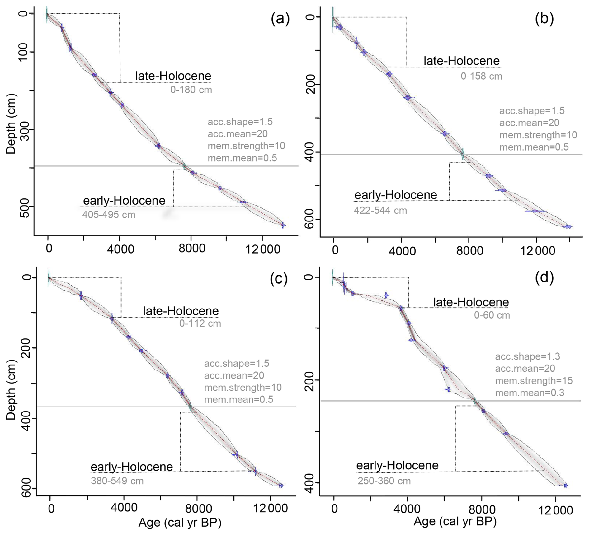
Figure 2Age-depth models for study sites in the Greater Victoria Water Supply Area (GVWSA). (a) Frog, (b) Begbie, (c) Swanson, and (d) Worley lakes. Each panel shows the calibrated 14C dates (blue), modelled mean age (red dash line), 95 % confidence intervals (grey stippled area) and modelling parameters. The horizontal grey line in each panel represents Mazama ash. Dashed brackets indicate targeted sampling intervals for the early- and late-Holocene. Parameter settings are also presented in light grey text; acc.shape, is the prior used to model accumulation rate, acc.mean is the prior for the mean in years per centimetre, mem.strength is the prior used to model memory, and mem.mean is the prior for the mean used to model memory.
Magnetic susceptibility profiles were developed for each core using a Bartington MS3 metre and MS2E core logging sensor (area of response 3.8 × 10.5 mm, depth of response 50 % at 1 mm and 10 % at 3.5 mm) recorded through Bartsoft PCv4.0 (Bartington Instruments, 2013). Measurements were taken at 0.5 cm intervals for Kayak samples and at 1 cm intervals for the Livingston cores, applying regular temperature drift corrections at every fifth reading. Each section was repeat measured and plotted to validate the profile with offsets applied as necessary.
Pollen and spores (henceforth pollen) were analyzed using traditional methods (Moore et al., 1991). For each targeted section of core, a 1 cm3 sediment sample was collected every 5 cm and sieved at 150 µm, retaining the finer component. An exotic Lycopodium tablet was added as a spike to each sample (20 848 ± 1546 spores per tablet; Department of Quaternary Geology, University of Lund, batch no. 1031). Pollen were extracted through chemical digestion involving HCl and acetolysis (Moore et al., 1991), with residues mounted in glycerine in the resultant slides. A minimum of 300 grains per slide was tallied using a Fisher Scientific Micromaster compound microscope at 400–1000 × magnification, with identification aided by published keys (Moore et al., 1991; Kapp, 1969; McAndrews et al., 1973) and reference slides. Taxa that were not definitively identified to genus or species were harmonized by family. Pollen counts were standardized using the decostand function in the vegan package for R 4.1.1 (Oksanen et al., 2022) and expressed as percentage of pollen per sample. Pollen diagrams were plotted using the Rioja Plot V0.1-20 package (Juggins, 2023) with a subset (relative abundance < 5 %) of taxa removed. Using the complete pollen dataset, with the exception of aquatics, taxa were classified as arboreal (AP) and non-arboreal (NAP) and grouped into fire-related functional categories, which are indicative of fire adaptations (Rowe, 1983; Agee, 1993; Wirth, 2005; Giuliano and Lacourse, 2023). Invaders are early-successional species that are killed by fire but widely dispersed and may be able to re-sprout or germinate quickly after disturbance. Evaders are highly flammable (fire promoting), serotinous, and early reproducers. Resisters survive fires of low to moderate severity due to their thick bark, self-pruning, and longevity and can be highly resistant to fire at maturity. Endurers are typically top killed by fire but can re-sprout from surviving underground adventitious buds or rhizomes. Lastly, avoiders are killed by fire and possess no fire adaptations. These species are shade-tolerant and dominate late-successional forests where fire is rare. Cumulative graphs of functional groups were also plotted using Rioja Plot.
Macrocharcoal (> 150 µm) was quantified from sieved subsamples (3 cm3) collected contiguously in 1 cm increments and treated with 5 % H2O2. Charcoal was defined as vegetative material altered by fire, resulting in black, opaque particles with vestigial cellular structure and submetallic lustre that was brittle upon manipulation (Brown and Power, 2013). The total number of charcoal fragments per sample (fragments cm−3) were tallied using a Leica stereomicroscope at 30–45 × magnification. To infer the origin of burnt materials, charcoal fragments were classified into four functional categories (woody materials, graminoids, deciduous/herbaceous materials, and unclassified) based on morphology (Enache and Cumming, 2006; Mustaphi and Pisaric, 2014; Feurdean, 2021). Key distinguishing features included presence of tracheids and bordered pits in wood charcoal (principally from conifers in the study area), rectangular cells and oval stomata in graminoid types, and diverging branches and netted venation in deciduous/herbaceous types (Jensen et al., 2007).
Charcoal peak detection was conducted using tapas (Finsinger and Bonnici, 2022) representing an R script version of trend and peak CharAnalysis (Higuera et al., 2009, 2011). CHAR (fragments per square centimetre per year) records were resampled and binned to equally spaced time intervals using median sample resolution and subsequently decomposed using robust locally weighted scatterplot smoothing to separate background from peak components. Smoothing window widths were defined for each record using sensitivity screening. The peak component was identified by a local Gaussian mixture model and minimum-count test at a 0.95 threshold, with suitability evaluated using a signal-to-noise index (SNI; Kelly et al., 2011). An index of fuels combusted was developed based on the ratio of graminoid to woody charcoal influx (GWI; Eq. 1) where CHARG and CHARW represent the interpolated charcoal accumulation rates for graminoid and woody materials, respectively. Values closer to one indicate higher rates of wood burning. An overall fuel morphotype index (FMI) was then calculated for each site interval from the average graminoid-to-woody charcoal ratio (Eq. 2).
Tapas-derived temporal distribution of peaks yielded estimates of fire frequency and FRIs, with the latter group-factored by site and interval (early- vs. late-Holocene). The distributions of FRIs were tested and failed assumption for normality using a Shapiro–Wilk's test on residuals of a linear model. To test if FRIs differed between the early- and late-Holocene at each site (dependent groupings), and to determine if a temporal shift in fire regimes occurred, a non-parametric Wilcoxon test was performed using rstatix 0.7.2 (Kassambara, 2023). A Kruskal–Wallis test was performed across all independent groupings (comparing FRIs between sites) followed by Dunn's pairwise comparisons to establish if there were significant spatial differences in fire regimes.
Standardized and transformed charcoal influx was used to reduce site effects and variability between records and examine biomass burning in the GVWSA (Marlon et al., 2013; Conedera et al., 2009; Marlon et al., 2016). Charcoal influx was calculated from charcoal concentrations for each record using their respective age-depth model. Base periods were defined representing the early (11 000–8000 cal yr BP) and late-Holocene (3000–0 cal yr BP). Influx values were scaled by min–max to maintain values between 0–1 and a Box–Cox transformation was then applied using boxcox.R in MASS R 7.3 (Ripley, 2023) to homogenize variance (Box-cox shift parameter α = 0.01, maximum likelihood estimation of lambda), with outputs rescaled by min–max and passed to Z scores using the mean and standard deviation of the data. The transformed data were presampled and binned in 20-year steps for the defined base periods, reducing sample frequency between records to common intervals without interpolation. A composite curve was fit using a local regression function (locfit.R from locfit 1.5; Loader, 2023) with fixed half window-width (smoothing parameter = 500) and bootstrapped confidence intervals (replacement by sites over 5000 replications) (Power et al., 2010; Blarquez et al., 2014; Marlon et al., 2016). Site curves were generated from the transformed, prebinned individual site data and fit using the same regression parameters.
To reconstruct climate a pollen derived index (DWHI) of xeric-adapted P. menziesii (Douglas-fir) to hydric-affiliated T. heterophylla (western hemlock) was used (Brown et al., 2006). Downcore estimates of mean annual precipitation (MAP) were subsequently generated using fossil DWHI values with a previously developed regression model of the regional surface pollen spectra and gridded mean monthly precipitation from the Parameter-elevation Regressions on Independent Slopes Model (PRISM; Brown et al., 2006; Brown and Schoups, 2015; Daly et al., 1994; Hamann and Wang, 2005). The regression is annual precipitation = 737.1563 × exp (1.632 × DWHI), with best estimates ranging from 740–3770 mm (Brown et al., 2019). Furthermore, to allow for temperature reconstruction and to compare MAPDWHI, spatially constrained (1° × 1°), time series of MAP (BIO12) and mean July temperature (Temperature_7) were extracted for the region from the PALEO-PGEM (Holden et al., 2019; Barreto et al., 2023) and HadCM3 series' (Beyer et al., 2020) using pastclim 1.2 (Leonardi et al., 2023). Their approach statistically downscales climatic reconstructions with a 1000-year resolution from emulations of an intermediate complexity atmosphere–ocean general circulation model. To supplement temperature reconstruction, these are presented alongside two previously published chironomid-based (temperature sensitive fossil midge) estimates of mean July air temperature (MJAT) from lakes located 30 and 240 km from the GVWSA (Pellatt et al., 2000; Lemmen and Lacourse, 2018).
3.1 Chronologies
Sediment cores from all lakes were principally comprised of brown gyttja with basal grey clay (total lengths [cm], Frog = 562, Begbie = 633, Swanson = 654, Worley = 474; Fig. 2). Age-depth models returned mean 95 % confidence ranges of 492, 543, 501, and 585 years for Frog, Begbie, Swanson, and Worley lakes, respectively.
3.2 Frog Lake
Results from climate, fire, and vegetation reconstructions reveal that forest characteristics and fire disturbance vary spatially and temporally, driven primarily by climate. Frog Lake's fire regime changes the least compared to other sites in the GVWSA. Estimated MAPDWHI is 1015 mm in the early-Holocene and 1265 mm in the late-Holocene (Fig. 7a). The pollen record at Frog Lake (Bone et al., 2026b; Fig. 3a), reflects the presence of woodland-like communities or a patchwork of forest stands and meadows in the early-Holocene. Pseudotsuga menziesii (< 0.5 %–23 %) increases after 10 000 cal yr BP and Poaceae peaks at 6 %. Along with elevated amounts of non-arboreal pollen, understorey taxa such as Rosaceae (1.5 %–12 %), Salix (1 %–9 %), Pteridium (1.5 %–13 %), and Apiaceae (0 %–3 %) indicate an open system (Allen et al., 1999). Diagnostic amounts of Artemesia (0 %–2 %) and Selaginella signal that rocky bluffs prevailed on southwestern aspects above the study site. High relative abundance of fire-related invader pollen types suggests regular disturbance. Charcoal analysis (Bone et al., 2026a; median SNI = 4.3), identifies eleven fire events in the early-Holocene (Fig. 3b), with FRIs ranging from 114–760 years with a mean FRI (mFRI) of 315 years (Fig. 8a). Peak magnitudes are relatively low. Along with a fuel morphotype index (0.72) that suggests lighter fuels (grasses, herbs, and leaves) are being consumed at higher rates alongside woody materials. It is conceivable that frequent fires were of smaller size, lower severity, and/or further from the basin of study.
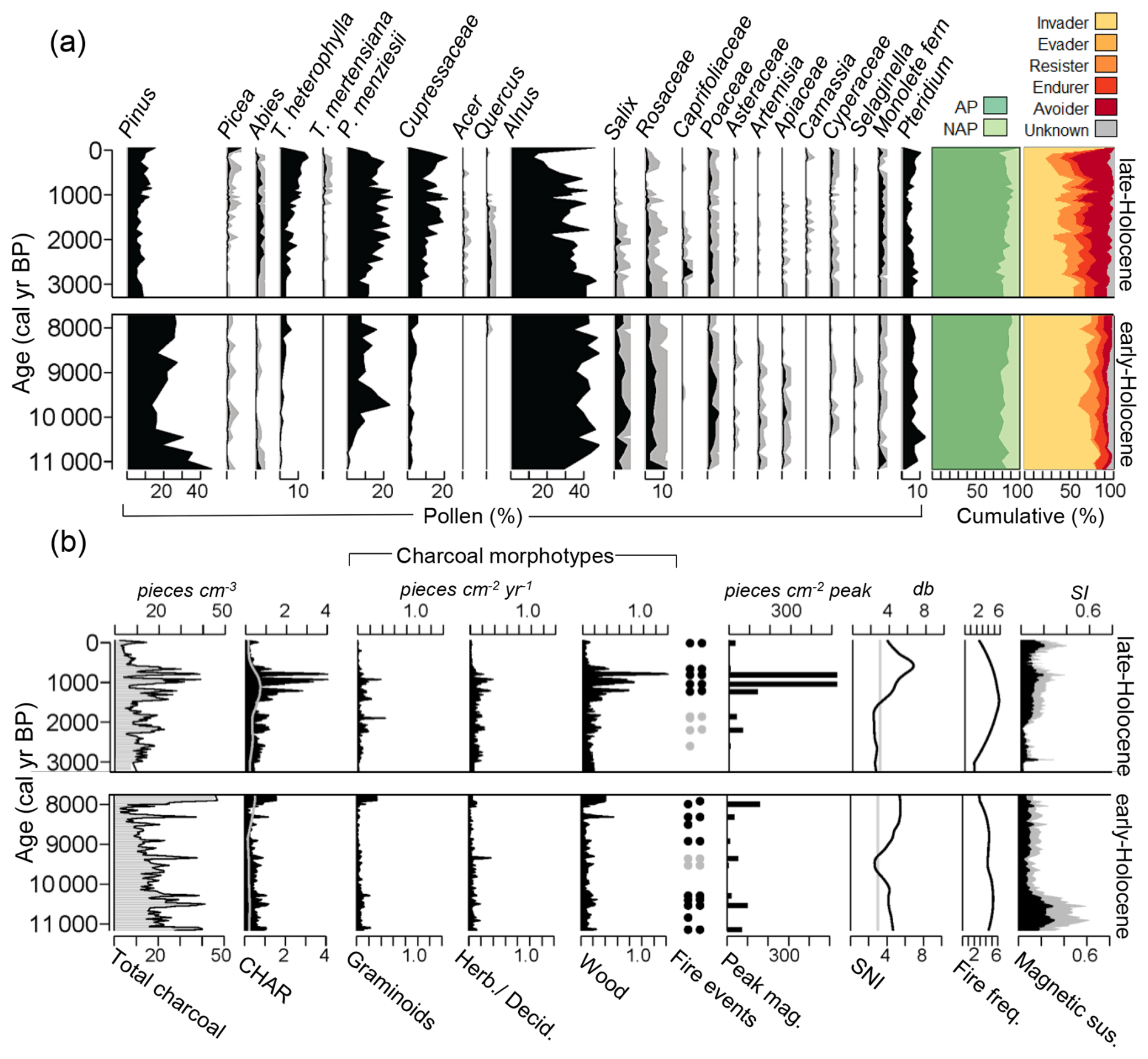
Figure 3Early- and late-Holocene pollen and charcoal results for Frog Lake. (a) Pollen diagram from left to right: taxa with relative abundance > 5 % (black area represents scaled pollen abundance (%) with 5× exaggeration (grey curve), cumulative pollen abundance (%) for arboreal (AP) and non-arboreal pollen (NAP) types, and fire functional groups. (b) Charcoal diagram from left to right: charcoal concentration, charcoal accumulation rate (CHAR) with grey curve showing 95 % threshold, charcoal morphotype influxes, significant positive fire-related peaks (black dots) and positive peaks with a low signal-to-noise index (SNI; grey dots) at a 95 % and 99 % threshold, SNI, smoothed fire frequency, magnetic susceptibility with black representing raw values and grey 2× exaggeration.
In the late-Holocene, Cupressaceae (0 %–22 %), T. heterophylla (0 %–15 %), Picea (0 %–8 %), and Abies (0 %–5 %) increase in abundance, elevating the cumulative proportion of arboreal pollen (Fig. 3a). Pseudotsuga menziesii remains co-dominant and a signal for Poaceae persists despite expansion of late-seral taxa. Sustained understorey indicators like Rosaceae and Pteridium, together with the emergence of additional distinguishing taxa such as Acer (0 %–1 %), Quercus (0 %–3 %), Caprifoliaceae (0 %–6 %), Saxifragaceae (0 %–1 %), and Camassia (0 %–1 %) suggest that these eastern forests maintained an open component. While the proportion of invader pollen decreases, resisters increase alongside avoiders. Charcoal analysis for the late-Holocene detected nine fire events (median SNI = 3.0). FRIs range from 38–646 years, with a mFRI of 323 years, indicating that fire was still prevalent. Both peak magnitude and charcoal accumulation rate of woody morphotypes increase (fuel morphotype index = 0.82), suggesting that fires were larger, of higher severity (consuming heavier fuels), and/or in closer proximity to the study site.
3.3 Begbie Lake
At Begbie Lake, MAPDWHI increases from 965 mm in the early-Holocene to 1610 mm in the late-Holocene (Fig. 7a), with changes in climate reflected in vegetation composition and FRIs. The early-Holocene pollen record (Hebda, 2021) is characterized by a high proportion of P. menziesii (9 %–43 %), which peaks at ca. 9500 cal yr BP. Poaceae (0 %–3 %) and Rosaceae (1 %–4 %) appear in lesser amounts than at Frog Lake, but their presence, along with a strong signal for Pteridium (4 %–12 %) and high cumulative non-arboreal pollen support the theory that open forests with well-developed understories occupied eastern areas at this time (Brown et al., 2019; Fig. 4a). The incursion of Cyperaceae (0.5 %–8 %) at the site near the top of the interval could indicate the beginning of regional moistening. The proportion of fire-related invaders are high, along with resisters, while avoiders are low, suggesting forests are fire-maintained. The early-Holocene charcoal analysis (Fig. 4b) at Begbie Lake (median SNI = 3.5) shows fire return intervals range from 88–704 years with a mFRI of 290 years (Fig. 8a). A number of high peak magnitude events suggest that large, high severity, and/or localized fires occurred at the site.
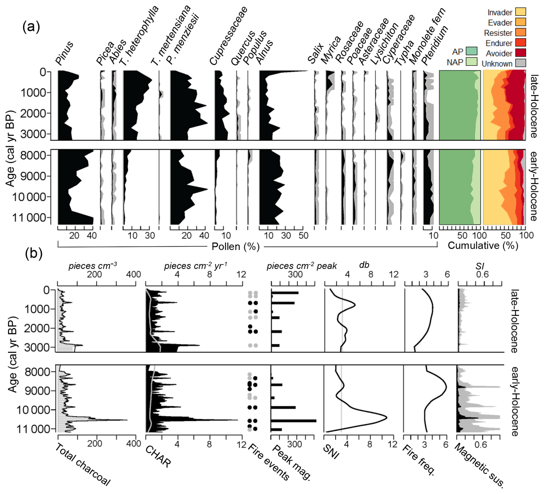
Figure 4Early- and late-Holocene pollen and charcoal results for Begbie Lake. (a) Pollen diagram from left to right: taxa with relative abundance > 5 % (black area represents scaled pollen abundance (%) with 5× exaggeration grey curve), cumulative pollen abundance (%) for arboreal pollen (AP) and non-arboreal pollen (NAP) types, and fire functional groups. (b) Charcoal diagram from left to right: charcoal concentration, charcoal accumulation rate (CHAR) with grey curve showing 95 % threshold, significant positive fire-related peaks (black dots) and positive peaks with a low signal-to-noise index (SNI; grey dots) at a 95 % and 99 % threshold, SNI, smoothed fire frequency, magnetic susceptibility with black representing raw values and grey 2× exaggeration.
In the late-Holocene, the arboreal pollen spectra increases as more closed canopy forests developed. Pseudotsuga menziesii (5 %–42 %) continues to persist at the site as T. heterophylla (8 %–33 %) and Cupressaceae (4 %–17 %) emerge as co-dominants. Picea (0 %–5 %) and Abies (< 0.5 %–5 %) also increase. Slight decreases in Roasaceae (0 %–2 %), Poaceae (0 %–1.5 %), and Pteridium (0 %–6 %) are evident. An increase in Lysichiton (0 %–2.5 %) occurs after ca. 3000 cal yr BP implying sub-canopy swamp formation, while Myrica (0 %–10 %) establishes vigorously at the site after ca. 1000 cal yr BP (Fig. 4a) reflecting local wetland development, which currently characterises the low-lying terrain around Begbie (Brown et al., 2019). Relative abundance of invaders decreases while avoiders and resisters increase. Eight positive peaks are identified in the charcoal analysis (SNI = 3.0), with FRIs ranging from 176–726 years and a mFRI of 394 years (Fig. 8a).
3.4 Swanson Lake
Moving west to Swanson Lake, a higher contrast is evident between early- and late-Holocene climate. The reconstruction of MAPDWHI at the site increases from 1255 mm in the early-Holocene to 2550 mm in the late-Holocene (Fig. 7a). Pinus (28 %–62 %) and Alnus (0 %–50 %) dominate the pollen record (Horrelt at al., 2026b) in the early-Holocene, along with stable amounts of P. menziesii (Fig. 5a). Distinguishing quantities of Plantaginaceae pollen (believed to be Penstemon spp.) reflect dry rocky out-crops around the site (Douglas et al., 1999). The proportion of invaders is the highest of all records, while resisters and avoiders are both low, an indication that vegetation on the exposed ridge was frequently disturbed. Evaluation of the early-Holocene charcoal analysis (Horrelt et al., 2026a; median SNI = 3.2) produces seventeen positive fire events through the interval (Fig. 5b), with FRIs ranging from 57–361 years and a mFRI of 195 years (Fig. 8a). Peak magnitudes are low and the fuel morphotype index (0.65) points to combustion of lighter fuels alongside wood.
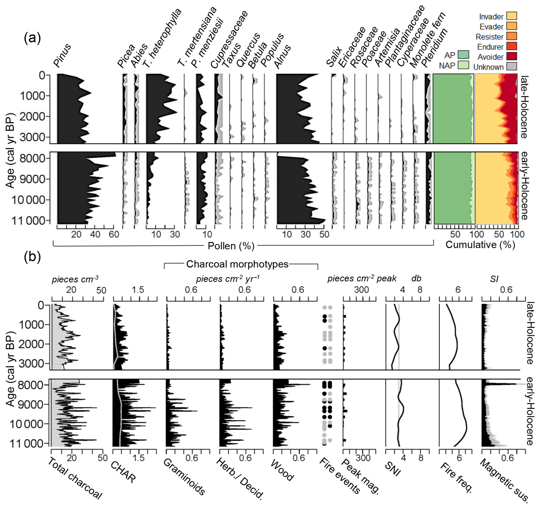
Figure 5Early- and late-Holocene pollen and charcoal results for Swanson Lake. (a) Pollen diagram from left to right: taxa with relative abundance > 5 % (black area represents scaled pollen abundance (%) with 5× exaggeration grey curve), cumulative pollen abundance (%) for arboreal pollen (AP) and non-arboreal pollen (NAP) types, and fire functional groups. (b) Charcoal diagram from left to right: charcoal concentration, charcoal accumulation rate (CHAR) with grey curve showing 95 % threshold, charcoal morphotype influxes, significant positive fire-related peaks (black dots) and positive peaks with a low signal-to-noise index (SNI; grey dots) at a 95 % and 99 % threshold, SNI, smoothed fire frequency, magnetic susceptibility with black representing raw values and grey 2× exaggeration.
In the late-Holocene, T. heterophylla (8 %–34 %) increases along with Cupressaceae (1 %–9 %), Picea (0 %–5 %) and Abies (0 %–5 %). Pinus (5 %–39 %), P. menziesii (1.5 %–12 %), and Alnus (21 %–46 %) remain relatively constant. Overall arboreal pollen abundance increases as the canopy closes. A notable decrease in invaders occurs as avoiders increase. Ten positive peaks are recorded from the charcoal analysis (median SNI = 2.4). FRIs range from 80–620 years with a mFRI of 311 years (Fig. 8a). Peak magnitude remains low but charcoal accumulation rate of woody morphotypes dominates (fuel morphotype index = 0.87), coinciding with the succession of late-seral forests and a potential change in fuel stratification.
At Swanson Lake, median SNI (3.2 and 2.4) was slightly lower compared to the other sites despite comparable sediment accumulation rates and good sampling resolution. However, it is important to recognize that SNI decreased at all sites in the late-Holocene relative to the early-Holocene, with values hovering around three. It is possible that this decrease is related to local wetland expansion intercepting overland charcoal inputs (Agee, 1993; Higuera et al., 2007; Kelly et al., 2011). The SNI at Swanson Lake is of greatest concern since it is generally below the threshold for suitable peak detection (Fig. 5b). Given that Swanson is the shallowest of the lakes studied, it is posited that it experienced more charcoal mixing, though not enough to entirely impede peak detection. The preponderance of fire-invading Pinus around Swanson Lake, however, suggests that fires did indeed continue to burn around the site. The site's location and exposure to elevated ignition probability (Perrakis et al., 2025) could be a sustained driver of high-frequency, low-severity fires through both the early and late-Holocene intervals, with estimates of FRIs consistent with Begbie and Frog lakes. Thus, while cautious interpretation of the late-Holocene fire record is warranted for Swanson Lake, it is presumed that the results generally reflect the fire regime.
3.5 Worley Lake
It is evident that a significant change in climate, vegetation, and fire regime occurs at the western most Worley Lake. Estimated MAPDWHI increases from 1340 to 3170 mm between the early- and late-Holocene, respectively (Fig. 7a). The early-Holocene pollen record (Bone et al., 2026d) at Worley Lake is characterised by P. menziesii (3 %–20 %) at ca. 10 000 cal yr BP, along with abundant Alnus (32 %–62 %). Tsuga heterophylla (0 %–22 %) increases sharply after ca. 9000 cal yr BP, signalling that climate driven changes in forest composition and structure may have been occurring earlier in the western part of the study region (Fig. 6a). Both Swanson and Worley Lakes had comparatively underdeveloped shrub and herbaceous layers, implying that western forests were less open than contemporaneous eastern forests. Evaluation of charcoal analysis (median SNI = 4.9) for the early-Holocene record (Bone et al., 2026c) produces thirteen positive fire-related peaks (Fig. 6b) and FRIs range from 87–377 years, with mFRI of 230 years (Fig. 8a). Peak magnitude is high and combustion of both heavier wood and lighter fuels (fuel morphotype index = 0.75) is occurring demonstrating potential for large, high severity, and/or localized fires at the site.
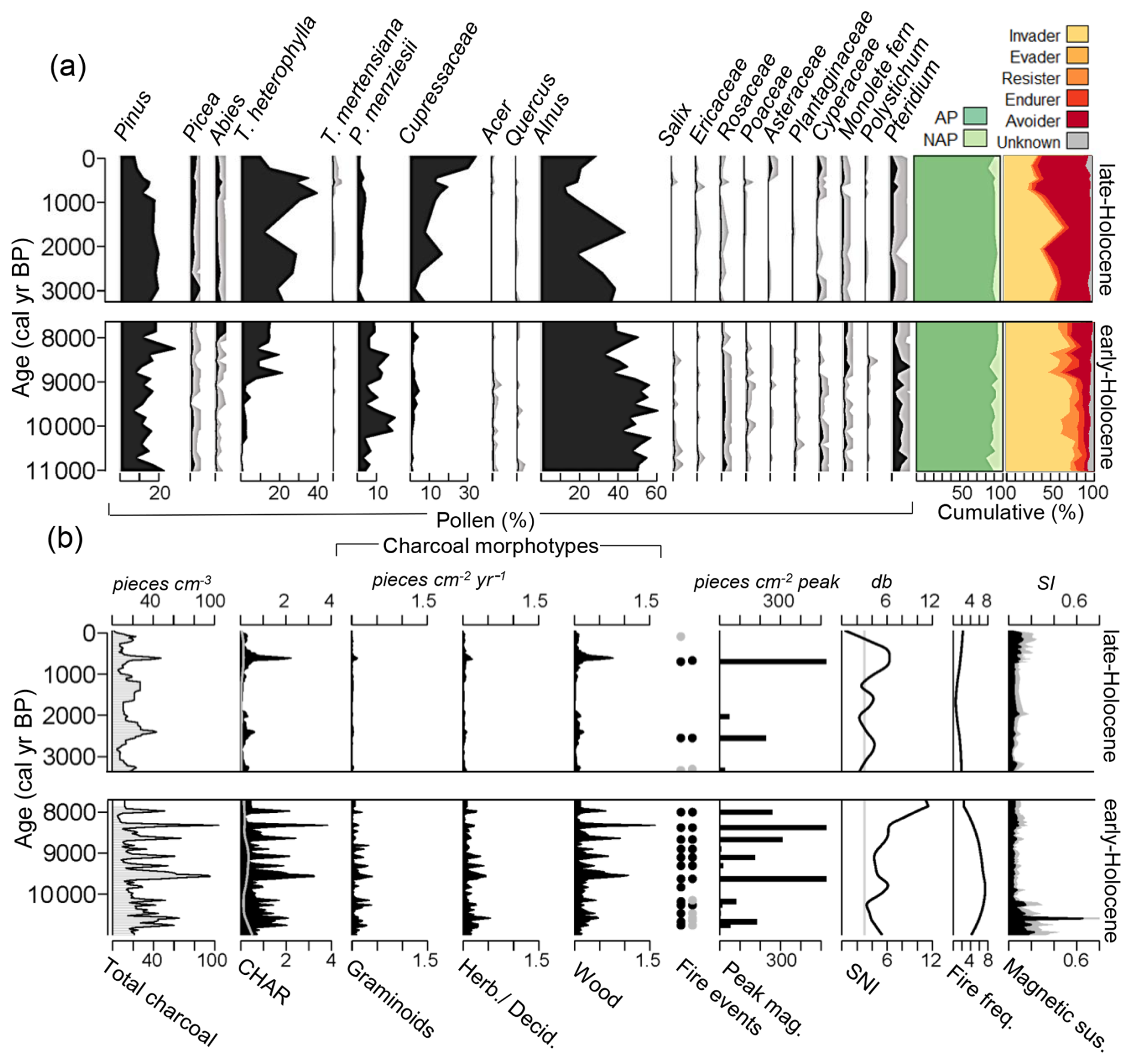
Figure 6Early- and late-Holocene pollen and charcoal results for Worley Lake. (a) Pollen diagram from left to right: taxa with relative abundance > 5 % (black area represents scaled pollen abundance (%) with 5× exaggeration grey curve), cumulative pollen abundance (%) for arboreal pollen (AP) and non-arboreal pollen (NAP) types, and fire functional groups. (b) Charcoal diagram from left to right: charcoal concentration, charcoal accumulation rate (CHAR) with grey curve showing 95 % threshold, charcoal morphotype influxes, significant positive fire-related peaks (black dots) and positive peaks with a low signal-to-noise index (SNI; grey dots) at a 95 % and 99 % threshold, SNI, smoothed fire frequency, magnetic susceptibility with black representing raw values and grey 2× exaggeration.
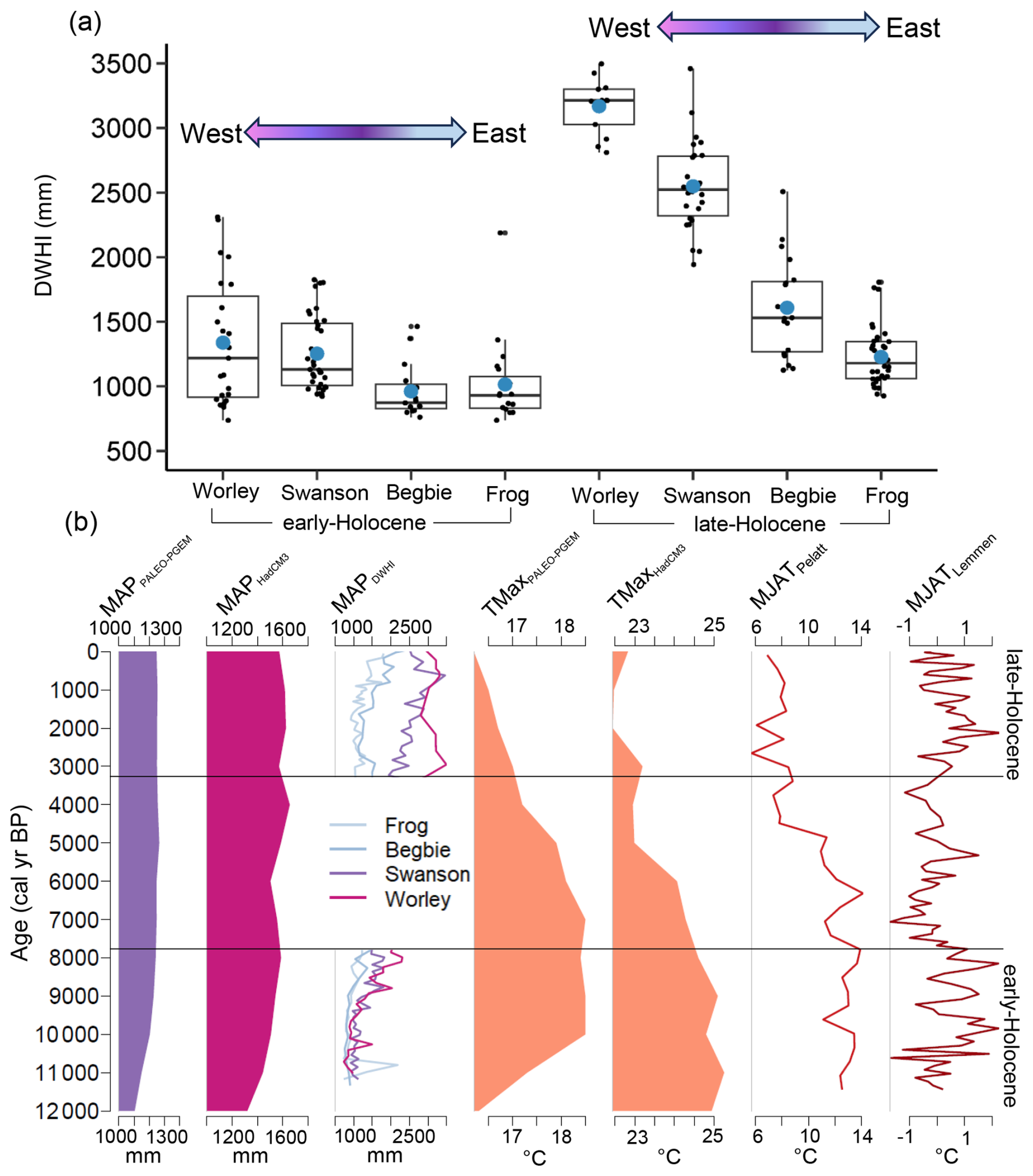
Figure 7Regional climate reconstruction for the Holocene. (a) Boxplots for the Douglas-fir/western hemlock index estimates of mean annual precipitation (MAPDWHI). Blue dots are means. (b) From left to right: MAP (BIO12) from PALEO-PGEM series (Baretto et al., 2023), MAP (BIO12) from HadCM3 (Beyer et al., 2020), down core MAPDWHI precipitation estimates for each site, mean July temperature (T7PALEO−PGEM) in degrees Celsius from PALEO-PGEM series (Baretto et al., 2023), mean July temperature (T7HadCM3) from HadCM3 (Beyer et al., 2020), chironomid inferred mean July air temperature (MJAT) (Pellatt et al., 2000), and chironomid inferred (MJAT) anomalies (Lemmen and Lacourse, 2018).
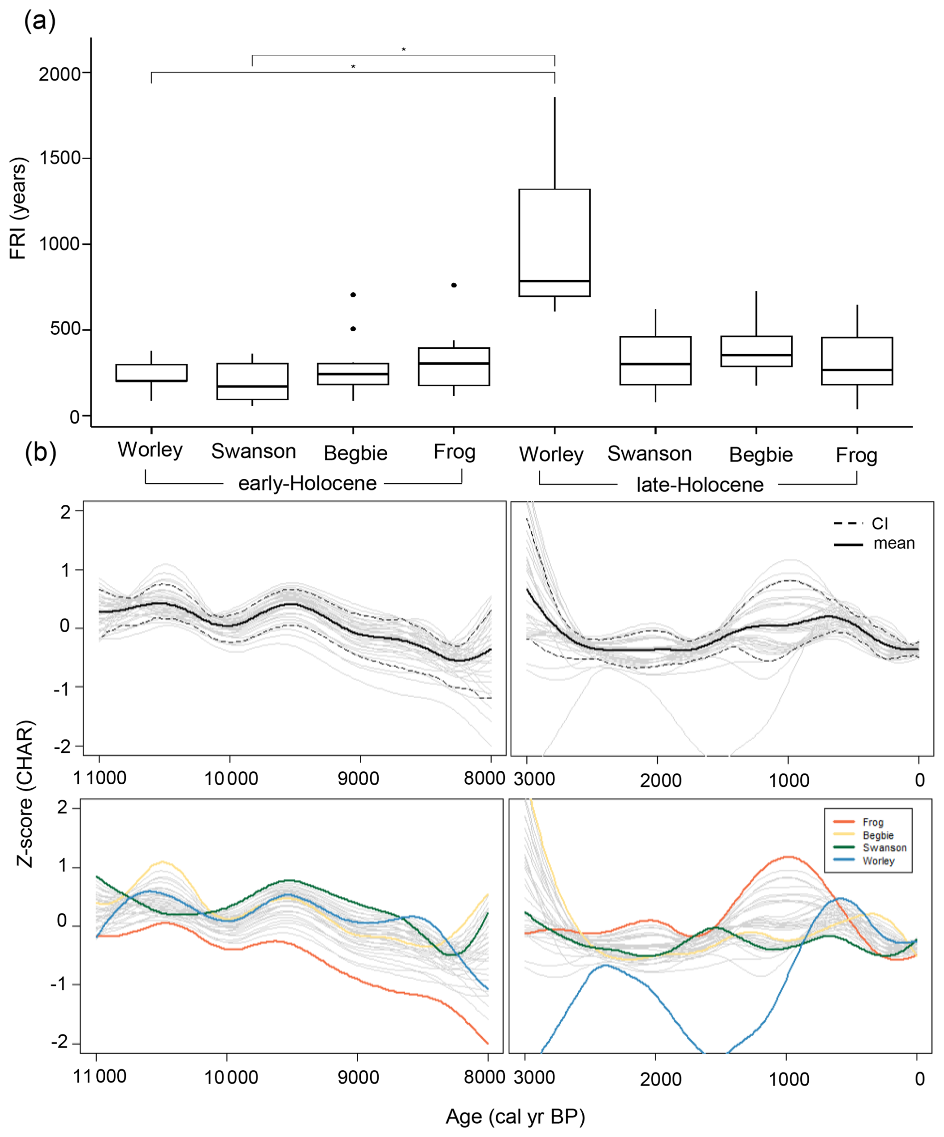
Figure 8Comparison of fire return intervals (FRI) and biomass burning. (a) FRI box and whisker plots comparing sites. Boxes represent the first and third quartiles, black line shows the median, whiskers are minimum and maximum range and black dots are outliers. Top black bracket and asterisks shows results of Wilcoxon signed rank test on paired samples (W = 0, p = 0.01, padj = 0.04, r = 0.68) and results of Dunn's pairwise comparison (Z = 3.35, padj(Bonferroni) = 0.022). (b) Standardized charcoal influx (Z scores) showing biomass burning based on a regression of presampled and binned records at 20-year time step and 500-year half width smoothing. Bootstrapped confidence intervals (CI) and mean from 5000 resampled iterations. Coloured curves present local fits for each site.
In the late-Holocene, a substantial decrease in P. menziesii (1 %–5 %) at Worley Lake coincides with increases in T. heterophylla (10 %–40 %), Picea (0.5 %–5 %), Abies (1 %–4 %), and Cupressaceae (3 %–35 %). The cuppressaceous pollen, possibly derived from both T. plicata and C. nootkatensis, increases considerably over the last 1000 years, during which time P. menziesii pollen decreases. Arboreal pollen increases with avoiders, while invaders and resisters decrease signalling characteristics of a late-seral closed forest. Only four significant peaks are detected from charcoal analysis in the late-Holocene (median SNI = 3.5). FRIs range from 609–1856 years and mFRI significantly increases to 1082 years. At least one fire with a high peak magnitude is detected and the fuel morphotype index increases (0.84), signifying that despite significant changes to disturbance intervals, the potential for large, high severity, and/or nearby fires exists at the site.
3.6 Comparison of climate, fire return intervals, and biomass burning
The synthesis of results from each site in the GVWSA demonstrates how fire regimes changed over time and how local biogeoclimatic conditions influence disturbance. The extraction of data from independent climate models aligns well with pollen derived reconstruction of precipitation and supports assumptions that climate was warmer during periods of greater fire disturbance. Mean annual precipitation (BIO12) from the PALEO-PGEM and HadCM3 series is consistent with the trend that precipitation increased from early- (PALEO-PGEM ranges = 1150–1240 mm; HadCM3 = 1534–1660 mm) to late-Holocene (PALEO-PGEM = 1250–1254 mm; HadCM3 = 1625–1675) in the region (Fig. 7b). Further, PALEO-PGEM and HadCM3 reveal that mean July temperature (Temperature_7) is relatively high in the early-Holocene (PALEO-PGEM = 17.3–18.5 °C; HadCM3 = 15.7–16.3 °C), peaking between 8000–10 000 cal yr BP (Fig. 7b). Thereafter, temperature steadily decreases through the late-Holocene (PALEO-PGEM = 15.7–16.1 °C; HadCM3 = 13.5–14.5 °C). Chironomid inferred MJAT likewise establishes warmer conditions in the early-Holocene (11.1–13.9 °C) compared to late-Holocene (5.7–8.8 °C), while the MJAT anomaly suggests that temperatures were consistently 0.5–2° C warmer than modern in the early-Holocene (Fig. 7b.; Pellatt et al., 2000; Lemmen and Lacourse, 2018).
The drier and warmer climate in the early-Holocene corresponds with shorter FRIs (more frequent fire) and higher rates of biomass burning across all sites. However, as climate cooled and moistened in the late-Holocene, a significant shift in fire regime occurs, with FRIs lengthening at Worley Lake. The Kruskall–Wallis test (H = 16, p = 0.025) compares FRI length between all sites and confirmed that they differ temporally or spatially. Subsequent Wilcoxon test (W = 0, padj = 0.04, r = 0.68) on paired dependent samples (comparing early and late-Holocene FRIs at same sites) further demonstrate that FRIs change significantly at Worley Lake, but not at other sites. A Dunn's pairwise comparison (Z = 3.35, padj [Bonferroni] = 0.022) of all independent groups (i.e. excluding comparisons between early- and late-Holocene FRIs from the same site) shows notable differences in FRIs between Worley Lake in the late-Holocene and Swanson Lake in the early-Holocene but it did not detect differences between other pairings (Fig. 8a). Overall, rates of biomass burning, (evaluated from transformed and binned Z scores of charcoal influx), are relatively synchronous during the early-Holocene. This is based on agreement between site-specific locally regressed curves (coloured lines; Fig. 8b) and the narrower boot-strapped confidence intervals (Blarquez et al., 2014). Charcoal influx is highest between ca. 9500 and 11 000 cal yr BP, decreasing thereafter (Fig. 8b). The late-Holocene shows greater variability as site curves diverge, confidence intervals widen, and charcoal influx at Worley Lake slows.
The pollen and charcoal records examined in this study indicate that climate-driven expansion of Coastal Douglas-fir (CDF)-like temperate forests occurred during the warm-dry early-Holocene, extending westward within the GVWSA and supporting an active fire regime characterized by both surface and crown fires (Gavin et al., 2003a; Giuliano and Lacourse, 2023; Brown et al., 2019, 2022; Hebda et al., 2024). In contrast, moistening and cooling in the late-Holocene corresponds with the establishment of modern moist Coastal Western Hemlock (CWH) forests, which experience less frequent mixed-severity fire. Notably, this early- to late-Holocene transition is most pronounced around western Worley Lake where CDF-like forest with frequent fire was replaced by CWHmm forest with much longer fire return intervals. This change emphasizes that western regions are particularly sensitive to future changes in forest composition and disturbance, creating potential challenges for water security.
4.1 Early-Holocene climate, vegetation, and fire
Climate reconstructions for western North America indicate that the early-Holocene was characterized by a warm-dry climate with greater seasonality and intensified summer drought (Mathewes and Heusser, 1981; COHMAP Members, 1988; Hebda, 1995; Rosenberg et al., 2004; Brown et al., 2006), with maximum temperatures occurring around ca. 9000–10 500 cal yr BP (Walker and Mathewes, 1987; Pellatt et al., 2000; Lemmen and Lacourse, 2018; Beyer et al., 2020; Brown et al., 2022; Baretto et al., 2023; Fig. 7b). On Vancouver Island, where a steep precipitation gradient exists today, reconstructed MAPDWHI indicates that widespread dry conditions (i.e. MAPDWHI generally < 1500 mm) prevailed in the GVWSA at this time (Brown et al., 2019) together with longer fire seasons (Brown et al., 2025). For perspective, these values are comparable to the driest sites on Vancouver Island in the modern CDF subzone (Meidinger and Pojar, 1991; Wong et al., 2004; Figs. 1b, c; 7a).
Consistent with this warm dry climate, open xeric forests prevailed across the GVWSA (Figs. 3a, 4a, 5a, 6a), extending > 100 km west of their present distribution (Brown and Hebda, 2002b). These forests were dominated by P. menziesii, a shade intolerant, thick-bark species adapted to frequent low- to moderate-severity fires (Agee, 1993; Wirth, 2005). Except for Pinus, other coniferous taxa were generally scarce until after ca. 9000 cal yr BP, when Picea, Abies, T. heterophylla and Cupressaceae gradually increased in abundance. Crucially, early successional taxa, such as Pinus (most likely Pinus contorta), Alnus, Salix, and Poaceae, were also widely abundant, suggesting regular disturbances that favoured pioneering species with high rates of dispersal, germination, and/or re-sprouting (Agee, 1993; Wirth, 2005). Fire-promoting Pteridium, whose deep rhizomes enable it to endure disturbance, also prevailed at this time (Crane, 1990).
Charcoal records indicate that fires were more frequent at all sites across the GVWSA in comparison to the late-Holocene (Fig. 8a), with no clear east-west differentiation in fire return intervals. Lower peak magnitudes at Frog and Swanson lakes could suggest smaller or lower severity fires, whereas higher peak magnitudes at Begbie and Worley lakes, occasionally with coinciding magnetic susceptibility peaks, indicate larger and/or higher severity fires (Rummery, 1981; Gedye et al., 2000; Dunnette et al., 2014; Figs. 3b, 4b, 5b,`6b). Charcoal morphotypes further show that graminoid-to-woody charcoal influx ratios were higher at all sites, suggesting that both surface and crown fires were burning, with the former possibly in open and/or exposed areas. Transformed and amalgamated total charcoal influx reveal that biomass burning was synchronous and widespread at this time, peaking around ca. 10,500 cal yr BP, coincidental with the regional thermal maximum (Mathewes and Heusser, 1981; Walker and Pellatt, 2003; Brown et al., 2022; Fig. 7b). An overall reduction in charcoal influx around 8200 cal yr BP could be related to northern hemisphere cooling (Alley et al., 1997; Barber et al., 1999).
4.2 Late-Holocene climate and shifting fire regime
Regional cooling and moistening occurred after 6000 cal BP, leading to the steep precipitation gradient that characterizes the coastal rainforest complex today, including the GVWSA (COHMAP Members, 1988; Hebda, 1995; Brown et al., 2006; Rosenberg et al., 2004). These changes were driven by decreasing solar activity and changes in atmospheric pressure systems and oceanic currents (Wanner et al., 2008; Marlon et al., 2012). Regional temperature reconstructions show that mean July temperatures were lower in the late-Holocene compared to preceding millennia (Mathewes and Heusser, 1981; Pellatt et al., 2000; Beyer et al., 2020; Baretto et al., 2023; Fig. 7b). Regarding precipitation, reconstructed MAPDWHI remained relatively stable at eastern Frog Lake, though a marked early-to-late Holocene shift is evident at western Worley Lake, where precipitation increased from ca. 1340 to > 3000 mm (Fig. 7a).
These climatic changes had a marked effect on vegetation composition and distribution. Arboreal pollen increased at all sites as T. heterophylla and Cupressaceae (T. plicata and C. nootkatensis) expanded regionally (Figs. 3a, 4a, 5a, 6a). These shade-tolerant, late-successional fire avoiders are poorly adapted to fire disturbance, as are Picea (likely Picea stichensis) and Abies (likely Abies amabilis), which likewise increased in abundance. Concurrently, plants classified as fire invaders decreased, suggesting that mixed-conifer late-seral closed forests with infrequent disturbance developed across much of the GVWSA, excluding eastern forests where P. menziesii remained a key species.
Fire is less frequent in the GVWSA during the late-Holocene compared to the early-Holocene (Fig. 8a). Isolated events with larger peak magnitudes and increases in magnetic susceptibility, together with increases in woody charcoal morphotypes, punctuate records, and demonstrate the potential for higher severity, larger, and/or localized events that likely initiated crown involvement or consumed coarser fuels (Figs. 3b, 6b). Further, the increase in magnetics in recent centuries likely reflects human expansion, logging, and reservoir development (Wu et al., 2015; Magiera et al., 2019; Trofymow et al., 2025; Figs. 3b, 4b, 5b, 6b). In general, transformed charcoal influx show that biomass burning in the GVWSA was more variable in the late-Holocene compared to the early-Holocene (Fig. 8b). While periods of synchronous biomass burning occurred, asynchrony also emerged. Although there appears to be an overall decrease in charcoal influx in the GVWSA during the late-Holocene, some records indicate that increases did occur as climate cooled and moistened, consistent with other regional records (Brown and Hebda, 2002a; Hallett et al., 2003). On the adjacent mainland, Hallet et al. (2003) reveal elevated fire activity from ca. 1500–2500 cal yr BP, referring to it as the Fraser Valley Fire Period. In the GVWSA, coincident increases in burning around 1000 cal yr BP may better align with the Medieval Climate Anomaly (ca. 750–1250 cal yr BP). However, past human activity has also been proposed to explain the trend (Brown and Hebda, 2002a; Gavin et al., 2007; Walsh et al., 2015).
Within the late-Holocene ecoclimatic framework, it should be noted that Quecus garryana emerged as a minor forest constituent between 2000 and 3000 cal BP, especially in drier eastern areas (Figs. 3a, 4a, 5a, 6a). In these drier forests, this was accompanied by an increase in Caprifoliaceae, possibly Lonicera hispidula, an understory plant sometimes associated with oak (Pojar et al., 1994; Lea, 2011). Quercus garryana is a fire enduring species capable of re-sprouting from lateral roots or forming new crowns after fire (Agee, 1996). While it reached its maximum extent during the mid-Holocene (Pellatt et al., 2001; Lucas and Lacourse, 2013), its subtle resurgence in the late-Holocene is less recognized (Allen, 1995; Brown et al., 2019) and possibly linked to Indigenous land management activities (McDadi and Hebda, 2008; Pellatt and Gedalof, 2014; Pellatt et al., 2015; Brown et al., 2002b, 2019; Barlow et al., 2021). An archaeological impact assessment within the GVWSA recovered artefacts of Marpole origin (Burley, 1980; Vincent et al., 2002), a cultural period that dates to as early as 2350 yr BP, overlapping with the Quercus signal in the sediment records, suggesting that the oak signal may be related to human activity.
4.3 Informing future fire regime change in temperate forest
The potential for past trends to reflect future changes in climate, vegetation, and fire is conceivable given that palaeoecological interpretations and predictive models are in good agreement. For example, the substantial changes in fire disturbance that occur at Worley Lake demonstrate the extent of shifting fire regimes in the past, providing first-order insights into possible future conditions (Figs. 6b, 8a). Mean annual temperature in British Columbia is projected to increase by 1.6 (1.1, 2.1)–5.2 (4.3, 6.5) °C by the end of the century, depending on the emissions scenario (RCP2.6, RCP8.5) and region, with the coast experiencing the least amount of warming (Bush and Lemmen, 2019; PCIC, 2024). These changes are in line with the estimates of past mean monthly maximum temperature fluctuations (2–5 °C) during the early-Holocene but are projected to occur on a much shorter time span. Early-to-late Holocene differences in DWHI establish a historical precedent for a return to a much drier climate (Fig. 7a). While forecasting precipitation is complicated by seasonal variability and low confidence (Bush and Lemmen, 2019), predictions for the region suggest overall increases in annual precipitation, coupled with worsening summer drought, resulting in less available effective summer moisture. Further, coastal regions could potentially see a 23 % (−48 % to −5 %) reduction in summer precipitation in a high-emissions scenario (SSP5-8.5) compared to baseline (Bush and Lemmen, 2019; PCIC, 2024).
Forest change simulations likewise align well with observations of past vegetation change. For example, the increase in P. menziesii that previously occurred in the western GVWSA in the early-Holocene may reoccur in the future based on models examining climate niche envelopes (Wang et al., 2012). Although Wang et al. (2012) found that the area suitable for P. menziesii could double by the end of the century, CDF forest is only expected to expand with a net gain that reflects a 20 % increase in its currently restricted range (0.2 million ha). A more nuanced interpretation is P. menziesii increases will be affiliated with the likely expansion of drier CWHxm as it displaces Vancouver Island interior and western rainforest. Increased disturbance and preferential reforestation with climate adapted species will also favor future expansion of P. menziesii (Uchytil, 1991).
With respect to fire disturbance, the paleofire reconstruction similarly favours model forecasts, with current trends supporting the notion that wildfire disturbance is increasing in the region (Hanes et al., 2019; Parisien et al., 2023). While this study reveals that fire increased regionally in the past (Pellatt et al., 2001; Lucas and Lacourse, 2013; Cwynar, 1987; Allen, 1995; Brown and Hebda, 2002b; Fig. 6c), FRIs actually change little in eastern xeric areas through time, with lower charcoal peak magnitudes and charcoal morphotypes indicating that the fire mosaic was somewhat less severe in the early-Holocene, possibly due to reduced fuel loading. Thus, for dry eastern areas, it is suggested that past and future changes are likely to be governed more by shifts in fire severity and fuel connectivity than frequency. The fire reconstruction shows that the eastern GVWSA has experienced fire throughout the Holocene, implying that the future may be characterized by more frequent, lower-severity events.
In contrast to present-day, moister western regions in the GVWSA were previously as fire-prone as the eastern sites are today, revealing the potential for a future marked change in fire regime. Paleofire reconstructions reveal that western GVWSA was characterized by large-magnitude events and higher charcoal influx during the early-Holocene, suggesting greater past fire activity compared to present (Figs. 6b, 8a, b). Similarly, simulations of future fire regimes for coastal temperate forests in the Pacific Northwest region of North America show that the largest projected increases in burn probability, fire size, and fire frequency, could occur in the coolest, wettest, and most northern areas (Dye et al., 2024), like the western GVWSA.
The role of humans in modifying fire regime, including Indigenous burning and more recent activities such as forest clearance, reservoir development, and modern fire suppression must also be acknowledged. Archaeological evidence and oral histories suggest cultural burning in central and eastern GVWSA (Eldridge and Seip, 2002), consistent with the presence of Q. garryana. Such use likely maintained open forests for hunting and resource access. Understanding how human activity interacts with climate-driven baselines will provide a more complete and practical understanding of future fire regimes. As shown by the 2024 Old Man Lake fire, which burned near the study location, anthropogenic ignitions under suitable fire weather conditions can trigger rapid fire spread. The convergence of cultural, climatic, and ecological drivers suggests that both eastern and western portions of the GVWSA are entering a period of heightened vulnerability, where adaptive management and fire-informed restoration strategies will be critical.
4.4 Limitations
The decomposition of charcoal records in this study follows a widely used methodology for identifying past fire events (Higuera et al., 2010). In using this approach, important factors to consider include quality of data, low-counts sections, variability in sedimentation rates, and sediment focusing processes. However, robust peak detection can typically be achieved if non-peak samples contain > 10 charcoal fragments and peak samples ≥ 20 fragments, coupled with the application of a locally defined threshold and minimum-count test, as was the case with the records analysed in this investigation. Given the numerous parameter choices involved (i.e., interpolation intervals, data transformations, background smoothing algorithms, window widths, and threshold criteria), it is also advised that the output be evaluated using sensitivity analyses to examine how the settings influence the number and timing of detected fire events. More recently, however, Anderson et al. (2023) highlighted key limitations of the method, including violations of the Poisson assumption for background charcoal and edge effects. Consequently, they recommended that particle count totals should be in the hundreds and that charcoal records should be evaluated using smoothed influx rather than discrete events. Adding further to these perspectives, several charcoal peaks in the Begbie Lake core that were identified as fire events using the approach of Higuera et al. (2010) were subsequently subsampled at 2 mm resolution to determine if fire-impacts could be detected (Hebda, 2022; Hebda et al., 2024). By combining high-resolution sampling with hierarchical clustering, the analysis was able to differentiate pre-fire, fire, and post-fire intervals, revealing changes in algal communities, inorganic sediment, ash-derived cations, metals (e.g., iron and chromium), and turbidity across charcoal peaks. Other studies similarly detected fire-related biogeochemical changes across charcoal peaks (Dunnette et al., 2014; Clark-Wolf et al., 2023), supporting the interpretation that the peaks identified do indeed correspond to fire events. Thus, while charcoal records are being used to generate valuable insights into past fire and fire impacts, further research is needed to resolve methodological uncertainties.
Comparison of climate, vegetation, and fire at four sites along ecological and climate gradients in a BC coastal temperate forest revealed a significant temporal shift in fire regime between the early- and late-Holocene intervals. The magnitude of change was most pronounced at the coolest and wettest end of the study area, suggesting that top-down climatic forcing was a significant driver of fire in the past, even in wetter forests that are less prone to disturbance today. At the same time, the persistence of species like P. menziesii (Douglas-fir), along with regular fire at drier eastern sites, suggests a tight feedback between climate and vegetation, demonstrating the potential for intrinsic drivers like fuel structure to influence fire regimes. As first-order analogues, the records suggest that more fire will be present on the land in the future, a finding that is consistent with predictive models that forecast increased fire associated with climate change and vegetation response (Wang et al., 2012, 2015, 2017; Sheehan et al., 2015; Dye et al., 2023). These findings have strong implications for the management of the high-value water supply area (Brown et al., 2018). For instance, as population grows and demand increases on southern Vancouver Island, the regional water purveyor (CRD) has purchased land in an adjacent watershed (Leech; Fig. 1), west of the study area, with plans to eventually extract water from that area (Stantec Consulting Ltd., 2022). Contemporary observations indicate that western areas have a moister climate and experience less fire, while the paleo history shows that these forests are vulnerable to change. On-going activities to secure and protect this future source of water involve reforestation and rehabilitation of lands, wildfire protection, and forest fuel management. Indeed, by distinguishing how changes in past climate altered vegetation and fire regime, this study provides critical insight into the current and future susceptibility of managed high-value watersheds to anthropogenic climate change impacts.
Data are available on the Neotoma Paleoecology Database.
-
BEGBIE pollen DOI: https://doi.org/10.21233/MYT8-WA75 (Hebda, 2021).
-
FROGVI pollen DOI: https://doi.org/10.21233/RY5S-E495 (Bone et al., 2026b), charcoal DOI: https://doi.org/10.21233/AGV1-H892 (Bone et al., 2026a).
-
SWANSNVI pollen DOI: https://doi.org/10.21233/KG7B-9G33 (Horrelt et al., 2026b), charcoal DOI: https://doi.org/10.21233/31J5-S285 (Horrelt et al., 2026a).
-
WORLEYVI pollen DOI: https://doi.org/10.21233/5DNG-CS22 (Bone et al., 2026d), charcoal DOI: https://doi.org/10.21233/PP10-C482 (Bone et al., 2026c).
CB, JAT, and KJB conceptualized the research. DRH, KJB, and CB conducted fieldwork and core collection. DRH and KJB completed magnetic susceptibility profile of sediment cores. DRH sampled cores, and processed charcoal. NC processed pollen. DRH completed pollen and charcoal identification and tabulation for Worley, Swanson, and Frog Lakes. NC completed pollen identification and tabulation for the Swanson record. DRH performed analysis and prepared figures. DRH and KJB wrote the paper with input from all authors.
The contact author has declared that none of the authors has any competing interests.
Publisher's note: Copernicus Publications remains neutral with regard to jurisdictional claims made in the text, published maps, institutional affiliations, or any other geographical representation in this paper. The authors bear the ultimate responsibility for providing appropriate place names. Views expressed in the text are those of the authors and do not necessarily reflect the views of the publisher.
We would like to thank Henry Hart for his contribution to surveying and characterizing prospective study sites within the Greater Victoria Water Supply Area. Thank you Nicholas Hebda for prior work completed at Begbie Lake and for use of the data from the Begbie core for this study. We would also like to recognize Joel Ussery and the CRD for their support and access to the watershed and their commitment to science and research in this protected area.
This research has been supported by the Natural Sciences and Engineering Research Council of Canada (grant no. 549502-2019).
This paper was edited by Julie Loisel and reviewed by two anonymous referees.
Agee, J. K.: Fire ecology of Pacific Northwest forests, Island press, Washington, DC, ISBN 1-55963-229-1, 1993.
Agee, J. K.: The influence of forest structure on fire behavior, in: Proceedings of the Seventeenth Annual Forest Vegetation Management Conference, Redding, California, USA, 16–18 January 1996, 52–68, https://www.fs.usda.gov/rm/pubs/rmrs_gtr292/1996_agee.pdf (last access: 21 February 2026), 1996.
Agee, J. K.: The complex nature of mixed severity fire regimes, in: Symposium proceedings, Mixed severity fire regimes: ecology and management, Volume AFE MISC03, edited by: Lagene, L., Zelnik, J., Cadwalladera, S., and Hughes, B., Washington State University Cooperative Extension Service/The Association for Fire Ecology, Spokane, Washington, USA, 17–19 November 2004, 1–10, https://www.ltrr.arizona.edu/~ellisqm/outgoing/dendroecology2014/readings/Agee2005.pdf (last access: 21 February 2026), 2005.
Allen, G. B.: Vegetation and Climate History of Southeast Vancouver Island, M.Sc. thesis, School of Earth and Ocean Sciences, University of Victoria, British Columbia, Canada, https://hdl.handle.net/1828/16938 (last access: 21 February 2026), 1995.
Alley, R. B., Mayewski, P. A., Sowers, T., Stuiver, M., Taylor, K. C., and Clark, P. U.: Holocene climatic instability: A prominent, widespread event 8200 yr ago, Geology, https://doi.org/10.1130/0091-7613(1997)025<0483:HCIAPW>2.3.CO;2, 25, 483–486, 1997.
Allen, G. B., Brown, K. J., and Hebda, R. J.: Surface pollen spectra from southern Vancouver Island, British Columbia, Canada, Can. J. Botany, 77, 786–799, https://doi.org/10.1139/b99-038, 1999.
Anderson, L., Presnetsova, L., Wahl, D. B., Phelps, G., and Gous, A.: Assessing reproducibility in sedimentary macroscopic charcoal count data, Quaternary Res., 111, 177–196, https://doi.org/10.1017/qua.2022.43, 2023.
Barber, D., Dyke, A., Hillaire-Marcel, C., Jenning, A. E., Andrews, J. T., Kerwin, M. W., Bilideau, R., McNeely, J., Southon, M. D., and Gagnon, J.-M.: Forcing of the cold event of 8,200 years ago by catastrophic drainage of Laurentide lakes, Nature, 400, 344–348, https://doi.org/10.1038/22504, 1999.
Barlow, C. M., Pellatt, M. G., and Kohfeld, K. E.: Garry oak ecosystem stand history in Southwest British Columbia, Canada: implications of environmental change and indigenous land use for ecological restoration and population recovery, Biodivers. Conserv., 30, 1655–1672, https://doi.org/10.1007/s10531-021-02162-2, 2021.
Barreto, E., Holden, P. B., Edwards, N. R., and Rangel, T. F.: PALEO-PGEM-Series: a spatial time series of the global climate over the last 5 million years (Plio-Pleistocene), Global Ecol. Biogeogr., 32, 1034–1045, https://doi.org/10.1111/geb.13683, 2023.
Bartington Instruments: Bartsoft for PC (4.0), Bartington Instruments Ltd. [computer software], https://www.bartingtondownloads.com/document-category/sw/ (last access: 21 February 2026), 2013.
BC Forest Analysis and Inventory Branch: VRI - 2024 - Forest Vegetation Composite Polygons, Vegetation Resource Inventory [data set], https://catalogue.data.gov.bc.ca/dataset/6ba30649-14cd-44ad-a11f-794feed39f40 (last access: 15 October 2024), 2024.
BC Wildfire Service: Statistics and Geospatial Data: Wildfire Averages, https://www2.gov.bc.ca/gov/content/safety/wildfire-status/about-bcws/wildfire-statistics/wildfire-averages, last access: 10 September 2024.
Beyer, R. M., Krapp, M., and Manica, A.: High-resolution terrestrial climate, bioclimate and vegetation for the last 120,000 years, Scientific Data, 7, 236, https://doi.org/10.1038/s41597-020-0552-1, 2020.
Blaauw, M. and Christen, J. A.: Flexible paleoclimate age-depth models using an autoregressive gamma process, Bayesian Anal., 6, 457–474, https://doi.org/10.1214/11-BA618, 2011.
Blarquez, O., Vannière, B., Marlon, J. R., Daniau, A.-L., Power, M. J., Brewer, S., and Bartlein, P. J.: paleofire: An R package to analyse sedimentary charcoal records from the Global Charcoal Database to reconstruct past biomass burning, Comput. Geosci., 72, 255–261, 2014.
Bone, C., Brown, K. J., and Horrelt, D. R.: Frog Lake charcoal dataset, Version 1.0, Neotoma Paleoecology Database [data set], https://doi.org/10.21233/AGV1-H892, 2026a.
Bone, C., Brown, K. J., and Horrelt, D. R.: Frog Lake pollen dataset, Version 1.0, Neotoma Paleoecology Database [data set], https://doi.org/10.21233/RY5S-E495, 2026b.
Bone, C., Brown, K. J., and Horrelt, D. R.: Worley Lake charcoal dataset, Version 1.0, Neotoma Paleoecology Database [data set], https://doi.org/10.21233/PP10-C482, 2026c.
Bone, C., Brown, K. J., and Horrelt, D. R.: Worley Lake pollen dataset, Version 1.0, Neotoma Paleoecology Database [data set], https://doi.org/10.21233/5DNG-CS22, 2026d.
Bowman, D. M., Williamson, G. J., Abatzoglou, J. T., Kolden, C. A., Cochrane, M. A., and Smith, A. M.: Human exposure and sensitivity to globally extreme wildfire events, Nature Ecology & Evolution, 1, 0058, https://doi.org/10.1038/s41559-016-0058, 2017.
Brown, K. J. and Hebda, R. J.: Ancient fires on southern Vancouver Island, British Columbia, Canada: a change in causal mechanisms at about 2,000 ybp, Environ. Archaeol., 7, 1–12, https://doi.org/10.1179/env.2002.7.1.1, 2002a.
Brown, K. J. and Hebda, R. J.: Origin, development, and dynamics of coastal temperate conifer rainforests of southern Vancouver Island, Canada, Can. J. Forest Res., 32, 353–372, https://doi.org/10.1139/x01-197, 2002b.
Brown, K. J. and Power, M. J.: Charred Particle Analyses, in: The Encyclopedia of Quaternary Science, edited by: Elias, S. A., Elsevier, Amsterdam, 2, 716–729, 2013.
Brown, K. J. and Schoups, G.: Multi-millennial streamflow dynamics in two forested watersheds on Vancouver Island, Canada, Quaternary Res., 83, 415–426, https://doi.org/10.1016/j.yqres.2015.03.003, 2015.
Brown, K. J., Fitton, R. J., Schoups, G., Allen, G. B., Wahl, K. A., and Hebda, R. J.: Holocene precipitation in the coastal temperate rainforest complex of southern British Columbia, Canada, Quaternary Sci. Rev., 25, 2762–2779, https://doi.org/10.1016/j.quascirev.2006.02.020, 2006.
Brown, K. J., Nielsen, A. B., Fitton, R. J., and Hebda, R. J.: Postglacial evolution and spatial differentiation of seasonal temperate rainforest in western Canada, The Holocene, 18, 715–727, https://doi.org/10.1177/0959683608091783, 2008.
Brown, K. J., Power, M. J., and Hebda, N. J.: Integrating paleoecology into landscape management, in: Proceedings of the VIII International Conference on Forest Fire Research, 2–16 November 2018, edited by: Viegas, D. X., Coimbra, Portugal, 1137–1145, https://doi.org/10.14195/978-989-26-16-506_127, 2018.
Brown, K. J., Hebda, N. J. R., Schoups, G., Conder, N., Smith, K. A. P., and Trofymow, J. A.: Long-term climate, vegetation and fire regime change in a managed municipal water supply area, British Columbia, Canada, The Holocene, 29, 1411–1424, https://doi.org/10.1177/0959683619854523, 2019.
Brown, K. J., Hebda, N. J., Hebda, R. J., Fitton, R., Trofymow, J. A., and Conder, N.: Development and wildfire dynamics of dry coastal temperate forests, BC, Canada, Can. J. Forest Res., 52, 1320–1333, https://doi.org/10.1139/cjfr-2022-0020, 2022.
Brown, K. J., Dietze, E., Walsh, M., Hennebelle, A., and Power, M.: Charred Particles and Other Paleofire Proxies, in: Encyclopedia of Quaternary Science, Vol. 3, edited by: Bradshaw, R., Elsevier, 19 pp., https://doi.org/10.1016/B978-0-323-99931-1.00082-9, 2025.
Burley, D. V.: Marpole: Anthropological Reconstructions of a Prehistoric Northwest Coast Culture Type, Department of Archaeology Publications 8. Archaeology Press, Simon Fraser University, Burnaby, BC, ISBN: 0-86491-026-6, 1980.
Burton, C., Lampe, S., Kelley, D. I., Thiery, W., Hantson, S., Christidis, N., Gudmundsson, L., Forrest, M., Burke, E., Chang, J., Huang, H., Ito, A., Kou-Giesbrecht, S., Lasslop, G., Li, W., Nieradzik, L., Li, F., Chen, Y., Randerson, J., Reyer, C. P. O., and Mengel, M.: Global burned area increasingly explained by climate change, Nat. Clim. Change, 14, 1186–1192, https://doi.org/10.1038/s41558-024-02140-w, 2024.
Bush, E. and Lemmen, D. S.: Canada's changing climate report, Government of Canada, Ottawa, ON, Canada, ISBN: 978-0-660-30222-5, 2019.
Chen, B., Wu, S., Jin, Y., Song, Y., Wu, C., Venevsky, S., Xu, B., Webster, C., and Gong, P.: Wildfire risk for global wildland–urban interface areas, Nature Sustainability, 7, 474–484, https://doi.org/10.1038/s41893-024-01291-0, 2024.
Chevalier, M., Davis, B. A., Heiri, O., Seppä, H., Chase, B. M., Gajewski, K., Lacourse, T., Telford, R. J., Finsinger, W., Guiot, J., Kühl, N., Maezumi, S. Y., Tipton, J. R., Carter, V. A., Brussel, T., Phelps, L. N., Dawson, A., Zanon, M., Vallé, F., Nolan, C., Mauri, A., Vernal, A., Izumi, K., Holmström, L., Marsicek, J., Goring, S., Sommer, P. S., Chaput, M., and Kupriyanov, D.: Pollen-based climate reconstruction techniques for late Quaternary studies, Earth-Sci. Rev., 210, 103384, https://doi.org/10.1016/j.earscirev.2020.103384, 2020.
Clarke, H., Cirulis, B., Borchers-Arriagada, N., Bradstock, R., Price, O., and Penman, T.: Health costs of wildfire smoke to rise under climate change, npj Clim. Atmos. Sci., 6, 102, https://doi.org/10.1038/s41612-023-00432-0, 2023.
Clark-Wolf, K. D., Higuera, P. E., McLauchlan, K. K., Shuman, B. N., and Parish, M. C.: Fire-regime variability and ecosystem resilience over four millennia in a Rocky Mountain subalpine watershed, J. Ecol., 111, 2643–2661, https://doi.org/10.1111/1365-2745.14201, 2023.
COHMAP Members: Climatic Changes of the Last 18,000 years: Observations and Model Simulations, Science, 241, 1043–1052, https://doi.org/10.1126/science.241.4869.1043, 1988.
Conedera, M., Tinner, W., Neff, C., Meurer, M., Dickens, A. F., and Krebs, P.: Reconstructing past fire regimes: methods, applications, and relevance to fire management and conservation, Quaternary Sci. Rev., 28, 555–576, https://doi.org/10.1016/j.quascirev.2008.11.005, 2009.
Crane, M. F.: Pteridium Aquilinum, USDA Forest Service Index of Species Information, https://www.fs.fed.us/database/feis/plants/fern/pteaqu/all.html (last access: 12 October 2024), 1990.
CRD: Regional Water Supply: 2017 Strategic Plan, Capital Regional District, Victoria, British Columbia, Canada, https://www.crd.ca/government-administration/data-documents/regional-water-supply-2017-strategic-plan (last access: 21 February 2026), 2022.
Cunningham, C. X., Williamson, G. J., and Bowman, D. M.: Increasing frequency and intensity of the most extreme wildfires on Earth, Nature Ecology & Evolution, 8, 1420–1425, https://doi.org/10.1038/s41559-024-02452-2, 2024.
Cwynar, L. C.: Fire and the forest history of the North Cascade Range, Ecology, 68, 791–802, https://doi.org/10.2307/1938350, 1987.
Daly, C., Neilson, R. P., and Phillips, D. L.: A statistical-topographic model for mapping climatological precipitation over mountainous terrain, J. Appl. Meteorol. Clim., 33, 140–158, https://doi.org/10.1175/1520-0450(1994)033<0140:ASTMFM>2.0.CO;2, 1994.
DeLuca, T. H., MacKenzie, M. D., Gundale, M. J., and Holben, W. E.: Wildfire-produced charcoal directly influences nitrogen cycling in ponderosa pine forests, Soil Sci. Soc. Am. J., 70, 448–453, https://doi.org/10.2136/sssaj2005.0096, 2006.
Demarchi, D. A.: An Introduction to the Ecoregions of British Columbia, 3rd edn., Ecosystem Information Section, Ministry of Environment, Victoria, B.C., https://coilink.org/20.500.12592/5s1hrlm (last access: 2 March 2026), 2011.
Douglas, G. W., Meidinger, D. V., and Pojar, J. (Eds.): Illustrated Flora of British Columbia. Volume 4: Dicotyledons (Orobanchaceae Through Rubiaceae), B.C. Ministry of Environment, Lands & Parks and B.C. Ministry of Forests, Victoria. 427 pp., ISBN: 978-0-7726-3685-0, 1999.
Dunnette, P. V., Higuera, P. E., McLauchlan, K. K., Derr, K. M., Briles, C. E., and Keefe, M. H.: Biogeochemical impacts of wildfires over four millennia in a Rocky Mountain subalpine watershed, New Phytol., 203, 900–912, https://doi.org/10.1111/nph.12828, 2014.
Dye, A. W., Reilly, M. J., McEvoy, A., Lemons, R., Riley, K. L., Kim, J. B., and Kerns, B. K.: Simulated future shifts in wildfire regimes in moist forests of Pacific Northwest, USA, J. Geophys. Res.-Biogeo., 129, e2023JG007722, https://doi.org/10.1029/2023JG007722, 2024.
Egan, J., Staff, R., and Blackford, J.: A high-precision age estimate of the Holocene Plinian eruption of Mount Mazama, Oregon, USA, The Holocene, 25, 1054–1067, https://doi.org/10.1177/0959683615576230, 2015.
Eldridge, M. and Seip, L.: Sooke Reservoir Expansion: An Archaeological Impact Assessment (Permit 2002–121), Rep., on file at the BC Archaeology Branch, Victoria, BC, 2002.
Enache, M. D. and Cumming, B. F.: Tracking recorded fires using charcoal morphology from sedimentary sequence of Prosser Lake, British Columbia (Canada), Quaternary Res., 65, 282–292, https://doi.org/10.1016/j.yqres.2005.09.003, 2006.
Esri: ArcGIS Map Service World Topographic [basemap], October 26, 2017, https://www.arcgis.com/home/item.html?id=7dc6cea0b1764a1f9af2e679f642f0f5 (last access: 9 November 2024), 2024a.
Esri: ArcGIS Map Service World Imagery, December 12, 2009, https://www.arcgis.com/home/item.html?id=10df2279f9684e4a9 f6a7f08febac2a9 (last access: 9 November 2024), 2024b.
Feurdean, A.: Experimental production of charcoal morphologies to discriminate fuel source and fire type: an example from Siberian taiga, Biogeosciences, 18, 3805–3821, https://doi.org/10.5194/bg-18-3805-2021, 2021.
Finsinger, W. and Bonnici, I.: tapas: an R package to perform trend and peaks analysis, Zenodo [code], https://doi.org/10.5281/zenodo.6344463, 2022.
Fischer, H., Schüpbach, Gideon, G., Bigler, M., Röthilisberger, R., Erhardt E., Stocker, T. F., Mulvaney, R., and Wolff, E. W.: Millennial changes in North American wildfire and soil activity over the last glacial cycle, Nat. Geosci., 8, 723–727, https://doi.org/10.1038/ngeo2495, 2015.
Flannigan, M. D., Logan, K. A., Amiro, B. D., Skinner, W. R., and Stocks, B. J.: Future Area Burned in Canada, Climatic Change, 72, 1–16, https://doi.org/10.1007/s10584-005-5935-y, 2005.
Gavin, D. G., Brubaker, L. B., and Lertzman, K. P.: An 1800-year record of the spatial and temporal distribution of fire from the west coast of Vancouver Island, Can. J. Forest Res., 33, 573–586, https://doi.org/10.1139/x02-196, 2003a.
Gavin, D. G., Brubaker, L. B., and Lertzman, K. P.: Holocene Fire History of a Coastal Temperate Rain Forest Based on Soil Charcoal Radiocarbon Dates, Ecology, 84, 186–201, https://doi.org/10.1890/0012-9658(2003)084[0186:HFHOAC]2.0.CO;2 2003b.
Gavin, D. G., Hallett, D. J., Hu, F. S., Lertzman, K. P., Prichard, S. J., Brown, K. J., Lynch, J. A., Bartlein, P., and Peterson, D. L.: Forest fire and climate change in western North America: insights from sediment charcoal records, Front. Ecol. Environ., 5, 499–506, https://doi.org/10.1890/060161, 2007.
Gedye, S. J., Jones, R. T., Tinner, W., Ammann, B., and Oldfield, F.: The use of mineral magnetism in the reconstruction of fire history: A case study from Lago di Origlio, Swiss Alps, Palaeogeogr. Palaeocl., 164, 101–110, 2000.
Giuliano, C. and Lacourse, T.: Holocene fire regimes, fire-related plant functional types, and climate in south-coastal British Columbia forests, Ecosphere, 14, e4416, https://doi.org/10.1002/ecs2.4416, 2023.
Goring, S., Williams, J. W., Blois, J. L., Jackson, S. T., Paciorek, C. J., Booth, R. K., Marlon, J. R., Blaauw, M., and Christen, J. A.: Deposition times in the northeastern United States during the Holocene: establishing valid priors for Bayesian age models, Quaternary Sci. Rev., 48, 54–60, https://doi.org/10.1016/j.quascirev.2012.05.019, 2012.
Hai, J., Zhang, L., Gao, C., Wang, H., and Wu, J.: How does fire suppression alter the wildfire regime? A systematic review, Fire, 6, 424, https://doi.org/10.3390/fire6110424, 2023.
Hallett, D. J., Lepofsky, D. S., Mathewes, R. W., and Lertzman, K. P.: 11 000 years of fire history and climate in the mountain hemlock rain forests of southwestern British Columbia based on sedimentary charcoal, Can. J. Forest Res., 33, 292–312, https://doi.org/10.1139/x02-177, 2003.
Halofsky, J. S., Donato, D. C., Franklin, J. F., Halofsky, J. E., Peterson, D. L., and Harvey, B. J.: The nature of the beast: examining climate adaptation options in forests with stand-replacing fire regimes, Ecosphere, 9, e02140, https://doi.org/10.1002/ecs2.2140, 2018.
Hamann, A. and Wang, T. L.: Models of climatic normals for genecology and climate change studies in British Columbia, Agr. Forest Meteorol., 128, 211–221, https://doi.org/10.1016/j.agrformet.2004.10.004, 2005.
Hanes, C. C., Wang, X., Jain, P., Parisien, M.-A., Little, J. M., and Flannigan, M. D.: Fire-regime changes in Canada over the last half century, Can. J. Forest Res., 49, 256–269, https://doi.org/10.1139/cjfr-2018-0293, 2019.
Hebda, R. J.: British Columbia Vegetation and Climate History with Focus on 6 ka BP, Geogr. Phys. Quatern., 49, 55–79, https://doi.org/10.7202/033030ar, 1995.
Hebda, N. J., Brown, K. J., Conder, N., Walker, I. R., and Hebda, R. J.: Past wildfire effects on terrestrial vegetation and biogeochemistry in a drinking water supply catchment, Quaternary Sci. Rev., 340, https://doi.org/10.1016/j.quascirev.2024.108663, 2024.
Hebda, N. J. R.: Begbie Lake pollen dataset, Version 1, Neotoma Paleoecology Database [data set], https://doi.org/10.21233/MYT8-WA75, 2021.
Hebda, N. J. R.: Assessing wildfire risk to municipal drinking water using paleoecology, PhD dissertation, University of British Columbia, Canada, 204 pp., https://open.library.ubc.ca/collections/ubctheses/24/items/1.0421622 (last access: 10 October 2024), 2022.
Hessburg, P. F., Miller, C. L., Parks, S. A., Povak N. A., Taylor, A. H., Higuera, P. E., Prichard, S. J., North, M. P., Collins, B. M., Hurteau, M. D., Larson, A. J., Allen, C. D., Stephens, S. L., Rivera-Huerta, H., Stevens-Rumann, C. S., Daniels, L. D., Gedalof, Z., Gray, R. W., Kane, V. R., Churchill, D. J., Hagmann, R. K., Spies, T. A., Cansler, C. A., Belote, R. T., Veblen, T. T., Battaglia, M. A., Hoffman, C., Skinner, C. N., Safford, H D., and Salter, R. B.: Climate, Environment, and Disturbance History Govern Resilience of Western North American Forests, Front. Ecol. Evolution, 7, 239, https://doi.org/10.3389/fevo.2019.00239, 2019.
Higuera, P. E., Peters, M. E., Brubaker, L. B., and Gavin, D. G.: Understanding the origin and analysis of sediment-charcoal records with a simulation model, Quaternary Sci. Rev., 26, 1790–1809, https://doi.org/10.1016/j.quascirev.2007.03.010, 2007.
Higuera, P.: CharAnalysis 0.9: Diagnostic and analytical tools for sediment-charcoal analysis, User's Guide, Montana State University, University of Illinois, http://CharAnalysis.googlepages.com (last access: 9 September 2024), 2009.
Higuera, P. E., Gavin, D. G., Bartlein, P. J., and Hallett, D. J.: Peak detection in sediment–charcoal records: impacts of alternative data analysis methods on fire-history interpretations, Int. J. Wildland Fire, 19, 996–1014, 2011.
Hoffman, K. M., Wickham, S. B., McInnes, W. S., and Starzomski, B. M.: Fire exclusion destroys habitats for at-risk species in a British Columbia protected area, Fire, 2, 48, https://doi.org/10.3390/fire2030048, 2019.
Hoffman, K. M., Davis, E. L., Wickham, S. B., Schang, K., Johnson, A., Larking, T., Lauriault, P. N., Le, N. Q., Swerdfager, E., and Trant, A. J.: Conservation of Earth's biodiversity is embedded in Indigenous fire stewardship, P. Natl. Acad. Sci. USA, 118, e2105073118, https://doi.org/10.1073/pnas.2105073118, 2021.
Holden, P. B., Edwards, N. R., Rangel, T. F., Pereira, E. B., Tran, G. T., and Wilkinson, R. D.: PALEO-PGEM v1.0: a statistical emulator of Pliocene–Pleistocene climate, Geosci. Model Dev., 12, 5137–5155, https://doi.org/10.5194/gmd-12-5137-2019, 2019.
Horrelt, D. R., Brown, K. J., and Bone, C.: Swanson Lake charcoal dataset, Version 1.0, Neotoma Paleoecology Database [data set], https://doi.org/10.21233/31J5-S285, 2026a.
Horrelt, D. R., Brown, K. J., and Bone, C.: Swanson Lake pollen dataset, Version 1.0, Neotoma Paleoecology Database [data set], https://doi.org/10.21233/KG7B-9G33, 2026b.
Jensen, K., Lynch, E. A., Calcote, R., and Hotchkiss, S. C.: Interpretation of charcoal morpohtypes in sediments from Ferry Lake, Wisconsin, USA: do different plant fuel sources produce distinctive charcoal morphotypes?, The Holocene, 17, 907–915, https://doi.org/10.1177/0959683607082405, 2007.
Juggins, S.: riojaPlot: Stratigraphic diagrams in R, package version 0.1-20, GitHub [code], https://github.com/nsj3/riojaPlot (last access: 6 November 2024), 2023.
Kajak, Z, Kacprzak, K., and Polkowski, R.: Tubular bottom sampler, Ekol. Pol. B, 11, 159–165, 1965.
Kapp, R. O.: How To Know Pollen and Spores, W. C. Brown Co. Iowa, Dubuque, ISBN 0-697-04849-7, 1969.
Kassambara, A.: rstatix: Pipe-Friendly Framework for Basic Statistical Tests, R package version 0.7.2, Datanovia [code], https://rpkgs.datanovia.com/rstatix/ (last access: 30 October 2024), 2023.
Kelly, R. F., Higuera, P. E., Barrett, C. M., and Hu, F. S.: A signal-to-noise index to quantify the potential for peak detection in sediment–charcoal records, Quaternary Res., 75, 11–17, https://doi.org/10.1016/j.yqres.2010.07.011, 2011.
Knutti, R. and Sedláček, J.: Robustness and uncertainties in the new CMIP5 climate model projections, Nat. Clim. Change, 3, 369–373, https://doi.org/10.1038/nclimate1716, 2013.
Lea, T.: Garry Oak and Associated Ecosystems: Distribution and Description, Chapter 2, in: Restoring British Columbia's Garry Oak Ecosystems Principles and Practices, edited by: Clements, C., Carnahan, T., Dumoulin, L., Evans, A., Gonzales, E., Kohler, T., Kroeker, N., Lea, L., and Miller, M., Gary Oak Ecosystems Recovery Team (GOERT), Victoria, British Columbia, Canada, ISBN: 978-0-9732181-4-5, 2011.
Lemmen, J. and Lacourse, T.: Fossil chironomid assemblages and inferred summer temperatures for the past 14,000 years from a low-elevation lake in Pacific Canada, J. Paleolimnol., 59, 427–442, https://doi.org/10.1007/s10933-017-9998-3, 2018.
Leonardi, M., Hallett, E. Y., Beyer, R., Krapp, M., and Manica, A.: pastclim 1.2: an R package to easily access and use paleoclimatic reconstructions, Ecography, 3, e06481, https://doi.org/10.1111/ecog.06481, 2023.
Littell, J. S.: Drought and fire in the western USA: is climate attribution enough?, Curr. Clim. Change Rep., 4, 396–406, https://doi.org/10.1007/s40641-018-0109-y, 2018.
Livingstone, D. A.: A lightweight piston sampler for lake deposits, Ecology, 36, 137–139, https://doi.org/10.2307/1931439, 1955.
Liu, Y., Stanturf, J., and Goodrick, S.: Trends in global wildfire potential in a changing climate, Forest Ecol. Manag., 259, 685–697, https://doi.org/10.1016/j.foreco.2009.09.002, 2010.
Loader, C.: locfit: Local regression, likelihood and density estimation, R package version 1.5, CRAN [code], https://cran.r-project.org/web/packages/locfit/index.html (last access: 17 October 2024), 2023.
Lucas, J. D. and Lacourse, T.: Holocene vegetation history and fire regimes of Pseudotsuga menziesii forests in the Gulf Islands National Park Reserve, southwestern British Columbia, Canada, Quaternary Res., 79, 366–376, https://doi.org/10.1016/j.yqres.2013.03.001, 2013.
MacCarthy, J., Tyukavina, A., Weisse, M. J., Harris, N., and Glen, E.: Extreme wildfires in Canada and their contribution to global loss in tree cover and carbon emissions in 2023, Glob. Change Biol., 30, https://doi.org/10.1111/gcb.17392, 2024.
Magiera, T., Łukasik, A., Zawadzki, J., and Rösler, W.: Magnetic susceptibility as indicator of anthropogenic disturbances in forest topsoil: A review of magnetic studies carried out in Central European forests, Ecol. Indic., 106, https://doi.org/10.1016/j.ecolind.2019.105518, 2019.
Marlon, J. R.: What the past can say about the present and future of fire, Quaternary Res., 96, 66–87, https://doi.org/10.1017/qua.2020.48, 2020.
Marlon, J. R., Bartlein, P. J., Walsh, M. K., Harrison, S. P., Brown, K. J., Edwards, M. E., Higuera, P E., Power, M. J., Anderson, R. S., Briles, C., Brunelle, A., Carcaillet, C., Daniels, M., Hu, F. S., Lavoie, M., Long, C., Minckley T., Richard, P. J. H., Scott, A. C., Shafer, D. S., Tinner, W., Umbanhowar, C. E., and Whitlock, C.: Wildfire responses to abrupt climate change in North America, P. Natl. Acad. Sci. USA, 106, 2519–2524, https://doi.org/10.1073/pnas.0808212106, 2009.
Marlon, J. R., Bartlein, P. J., Gavin, D. G., Long, C. J., Anderson, R. S., Briles, C. E., Brown, K. J., Colombaroli, D., Hallet, D. J., Power, M. J., Scharf, E. A., and Walsh, M. K.: Long-term perspective on wildfires in the western USA, P. Natl. Acad. Sci. USA, 109, E535–E543, https://doi.org/10.1073/pnas.1112839109, 2012.
Marlon, J. R., Bartlein, P. J., Daniau, A. L., Harrison, S. P., Maezumi, S. Y., Power, M. J., Tinner, W., and Vanniére, B.: Global biomass burning: a synthesis and review of Holocene paleofire records and their controls, Quaternary Sci. Rev., 65, 5–25, https://doi.org/10.1016/j.quascirev.2012.11.029, 2013.
Marlon, J. R., Kelly, R., Daniau, A.-L., Vannière, B., Power, M. J., Bartlein, P., Higuera, P., Blarquez, O., Brewer, S., Brücher, T., Feurdean, A., Romera, G. G., Iglesias, V., Maezumi, S. Y., Magi, B., Courtney Mustaphi, C. J., and Zhihai, T.: Reconstructions of biomass burning from sediment-charcoal records to improve data–model comparisons, Biogeosciences, 13, 3225–3244, https://doi.org/10.5194/bg-13-3225-2016, 2016.
Mathewes, R. W. and Heusser, L. E.: A 12 000 year palynological record of temperature and precipitation trends in southwestern British Columbia, Can. J. Botany, 59, 707–710, https://doi.org/10.1139/b81-100, 1981.
Mattioli, W., Ferrara, C., Lombardo, E., Barbati, A., Salvati, L., and Tomao, A.: Estimating wildfire suppression costs: a systematic review, Int. For. Rev., 24, 15–29, https://doi.org/10.1505/146554822835224801, 2022.
McAndrews, J. H. and Power, D. M.: Palynology of the Great Lakes: the surface sediments of Lake Ontario, Can. J. Earth Sci., 10, 777–792, https://doi.org/10.1139/e73-071, 1973.
McDadi, O. and Hebda, R. J.: Change in historic fire disturbance in a Garry oak (Quercus garryana) meadow and Douglas-fir (Pseudotsuga menziesii) mosaic, University of Victoria, British Columbia, Canada: A possible link with First Nations and Europeans, Forest Ecol. Manag., 256, 1704–1710, https://doi.org/10.1016/j.foreco.2008.03.012, 2008.
Meidinger, D. and Pojar, J.: Ecosystems of British Columbia, BC Min. of For., Victoria, Special Rep. Series No. 6, 330 pp., ISSN 0843-6452, 1991.
Moore, P. D., Webb, J. A., and Collison, M. E.: Pollen analysis, Blackwell Scientific Publications, Oxford, UK, viii, 216 pp., ISSN 978-0-632-02176-5, 1991.
Moritz, M. A., Parisien, M. A., Batllori, E., Krawchuk, M. A., Van Dorn, J., Ganz, D. J., and Hayhoe, K.: Climate change and disruptions to global fire activity, Ecosphere, 3, 1–22, https://doi.org/10.1890/ES11-00345.1, 2012.
Moritz, M. A., Batllori, E., Bradstock, R. A., Gill, A. M., Handmer, J., Hessburg, P. F., Leonard, J., McCaffrey, S., Odion, D. C., Schoennagel, T., and Syphard, A. D.: Learning to coexist with wildfire, Nature, 51, 58–66, https://doi.org/10.1038/nature13946, 2014.
Mustaphi, C. J. C. and Pisaric, M. F. J.: A classification for macroscopic charcoal morphologies found in Holocene lacustrine sediments, Prog. Phys. Geog., 38, 734–754, https://doi.org/10.1177/0309133314548886, 2014.
Nakagawa, T., Tarasov, P., Staff, R., Ramsey, C. B., Marshall, M., Schlolaut, G., Bryant, C., Brauer, A., Lamb, H., Haraguchi, T., Gotanda, K., Kitaba, I., Kitagawa, H., van der Plicht, J., Yonenobu, H., Omori, T., Yokoyama, Y., Tada, R., and Yasuda, Y.: The spatio-temporal structure of the Lateglacial to early Holocene transition reconstructed from the pollen record of Lake Suigetsu and its precise correlation with other key global archives: Implications for palaeoclimatology and archaeology, Global Planet. Change, 202, 103493, https://doi.org/10.1016/j.gloplacha.2021.103493, 2021.
Oksanen, J., Simpson, G., Blanchet, F. G., Kindt, R., Legendre, P., Minchin, P., O'hara, R. B., Solymos, P., Stevens, H. M. H., Szöcs, E., Wagner, H. H., Barbour, M., Bedward, M., Bolker, B., Borcard, D., Carvalho, G., Chirico, M., Caceres, M., Durand, S., Evangelista, H., Fitzjohn, R., Friendly, M., Furneaux, B. R., Hannigan, G., Hill, M. O., Lahti, L., McGlinn, D., Oulette, M.-H., Cunha, E. R., Smith, T. W., Stier, A., ter Braak, C., and Weedon, J.: vegan community ecology package version 2.6-2 April 2022, CRAN [code], https://cran.r-project.org/ (last access: 6 October 2024), 2022.
Overpeck, J. T., Rind, D., and Goldberg, R.: Climate-induced changes in forest disturbance and vegetation, Nature, 343, 51–53, https://doi.org/10.1038/343051a0, 1990.
Parisien, M.-A., Dawe, D. A., Miller, C., Stockdale, C. A., and Armitage, O. B.: Applications of simulation-based burn probability modelling: a review, Int. J. Wildland Fire, 28, 913–926, https://doi.org/10.1071/WF19069, 2019.
Parisien, M. A., Barber, Q. E., Bourbonnais, M. L., Daniels, L. D., Flannigan, M. D., Gray, R. W., Hoffman, K. M., Jain, P., Stephens, S. L., Taylor, S. W., and Whitman, E.: Abrupt, climate-induced increase in wildfires in British Columbia since the mid-2000s, Communications Earth & Environment, 4, 309, https://doi.org/10.1038/s43247-023-00977-1, 2023.
PCIC: Plan2Adapt: Summary, Pacific Climate Impacts Consortium, https://services.pacificclimate.org/plan2adapt/app/, last access: 29 October 2024.
Pellatt, M. G., Smith, M. J., Mathewes, R. W., Walker, I. R., and Palmer, S. L.: Holocene treeline and climate change in the subalpine zone near Stoyoma Mountain, Cascade Mountains, southwestern British Columbia, Canada, Arct. Antarct. Alp. Res., 32, 73–83, https://doi.org/10.1080/15230430.2000.12003341, 2000.
Pellatt, M. G., Hebda, R. J., and Mathewes, R. W.: High-resolution Holocene vegetation history and climate from Hole 1034B, ODP leg 169S, Saanich Inlet, Canada, Mar. Geol., 174, 211–226, https://doi.org/10.1016/S0025-3227(00)00151-1, 2001.
Pellatt, M. G. and Gedalof, Z. E.: Environmental change in Garry oak (Quercus garryana) ecosystems: the evolution of an eco-cultural landscape, Biodivers. Conserv., 23, 2053–2067, https://doi.org/10.1007/s10531-014-0703-9, 2014.
Pellatt, M. G., McCoy, M. M., and Mathewes, R. W.: Paleoecology and fire history of Garry oak ecosystems in Canada: implications for conservation and environmental management, Biodivers. Conserv., 24, 1621–1639, https://doi.org/10.1007/s10531-015-0880-1, 2015.
Perrakis, D. P., Brown, K. J., Morrison, K., Taylor, S. W., and Horrelt, D. R.: Assessing wildfire potential in a coastal forest watershed, British Columbia, Canada, Forest Ecol. Manag., 590, 122796, https://doi.org/10.1016/j.foreco.2025.122796, 2025.
Pojar, J. and MacKinnon, A. (Eds.): Plants of the Pacific Northwest coast: Washington, Oregon, British Columbia and Alaska, Lone Pine Publishing, Redmond, WA, 526 pp., ISBN: 9781772130089, 1994.
Power, M. J., Marlon, J., Ortiz, N., Bartlein, P. J., Harrison, S. P., Mayle, F. E., Ballouche, A., Bradshaw, R. H. W., Caracaillet, C., Cordova, C., Mooney, S., Moreno, P. I., Prentice, I. C., Thonicke, K., Tinner, W., Whitlock, C., Zhang, Y., Zhao, Y., Ali, A. A., Anderson R. S., Beer, R., Behling, H., Briles, C., Brown, K. J., Brunelle, A., Bush, M., Camill, P., Chu, G. Q., Clark, J., Colombaroli, D., Connor, S., Daniau, A-L., Daniels, M., Dodson, J., Doughty, E., Edwards, M. E., Finsinger, W., Foster, D., Frechette, J., Gaillard, M-J., Gavin, D. G., Gobet, E., Haberle, S., Hallett, D. J., Higuera, P., Hope, G., Horn, S., Inoue, J., Kaltenrieder, P., Kennedy, L., Kong, Z. C., Larsen, C., Long, C. J., Lynch, J., McGlone, M., Meeks, S., Mensing, S., Meyer, G., Minckley, T., Mohr, J., Nelson, D. M., New, J., Newnham, R., Noti, R., Oswald, W., Pierce, J., Richard, P. J. H., Rowe, C., Sanchez Goni, M. F., Schuman, B. N., Takahara, H., Toney, J., Turney, C., Urrego-Sanchez, D. H., Umbanhowar, C., Vandergoes, M., Vanniere, B., Vescovi, E., Walsh, M., Wang, X., Williams, N., Wilmshurst, J., and Zhang, J. H.: Changes in fire regimes since the Last Glacial Maximum: an assessment based on a global synthesis and analysis of charcoal data, Clim. Dynam., 30, 887–907, https://doi.org/10.1007/s00382-007-0334-x, 2008.
Power, M. J., Bartlein, P. J., and Harrison, S. P.: Fire history and the Global Charcoal Database: A new tool for hypothesis testing and data exploration, Palaeogeogr. Palaeocl., 291, 52–59, https://doi.org/10.1016/j.palaeo.2009.09.014, 2010.
Ramsey, C. B.: Bayesian analysis of radiocarbon dates, Radiocarbon, 51, 337–360, https://doi.org/10.1017/S0033822200033865, 2009.
Reimer, P. J., Austin, W. E., Bard, E., Bayliss, A., Blackwell, P. G., Ramsey, C. B., Butzin, M., Cheng, H., Edwards, R., Friedrich, L. M., Grootes, P. M., Guilderson, T P., Hajdas, I., Heaton, T. J., Hogg, A. G., Hughen, K. A., Kromer, B., Manning, S. W., Muscheler, R., Palmer, J.G., Pearson, C., van der Plicht, J., Reimer, R. W., Richards, D. A., Scott, E. M., Southon, J. R., Turney, C. S. M., Wacker, L., Adolphi, F., Buntgen, U., Capano, M., Fahrni, S M., Fogtmann-Schulz, A., Friedrich, R., Kohler, P., Kudsk, S., Miyake, F., Olsen, J., Reinig, F., Sakamoto, M., Sookdeo, A., and Talamo, S.: The IntCal20 Northern Hemisphere radiocarbon age calibration curve (0–55 cal kBP), Radiocarbon, 62, 725–757, https://doi.org/10.1017/RDC.2020.41, 2020.
Renssen, H., Seppä, H., Crosta, X., Goosse, H., and Roche, D. M.: Global characterization of the Holocene thermal maximum, Quaternary Sci. Rev., 48, 7–19, https://doi.org/10.1016/j.quascirev.2012.05.022, 2012.
Ripley, B.: MASS: Modern applied statistics with S, R package version 7.3, CRAN [code], https://cran.r-project.org/web/packages/MASS/index.html (last access: 17 October 2024), 2023.
Rosenberg, S. M., Walker, I. R., Mathewes, R. W., and Hallett, D. J.: Midge-inferred Holocene climate history of two subalpine lakes in southern British Columbia, Canada, The Holocene, 14, 258–271, https://doi.org/10.1191/0959683604hl703rp, 2004.
Rowe, J. S.: Concepts of Fire Effects on Plant Individuals and Species, in: The Role of Fire in Northern Circumpolar Ecosystems, edited by: Wein, R. W. and MacLean, D. A., John Wiley and Sons, New York, 135–155, ISBN 0 471 10222 9, 1983.
Rummery, A. T.: The effects of fire on soil and sediment magnetism, Doctoral dissertation, University of Liverpool, 1981.
Senande-Rivera, M., Insua-Costa, D., and Miguez-Macho, G.: Spatial and temporal expansion of global wildland fire activity in response to climate change, Nat. Commun., 13, 1208, https://doi.org/10.1038/s41467-022-28835-2, 2022.
Sheehan, T., Bachelet, D., and Ferschweiler, K.: Projected major fire and vegetation changes in the Pacific Northwest of the conterminous United States under selected CMIP5 climate futures, Ecol. Model., 317, 16–29, https://doi.org/10.1016/j.ecolmodel.2015.08.023, 2015.
Stantec Consulting Ltd.: Capital Regional District, Regional Water Supply, 2022 Master Plan, IWS Report No. 1186, Victoria, BC, Canada, https://www.crd.ca/media/file/regional-water-supply-2022-master-plan (last access: 21 February 2026), 2022.
Uchytil, R. J.: Pseudotsuga menziesii var. Menziesii, in: Fire Effects Information System, U.S. Department of Agriculture, Forest Service, Rocky Mountain Research Station, Fire Sciences Laboratory, https://www.fs.usda.gov/database/feis/plants/tree/psemenm/all.html (last access: 3 November 2024), 1991.
Vincent, R., Mathews, D., and Eldridge, M.: Sooke Lake Reservoir Expansion Phase II: An Archeological Impact Assessment, Permit 2202-336, Victoria, Capital Regional District, 2002.
Walker, I. R. and Mathewes, R. W: Chironomidae (Diptera) and postglacial climate at Marion Lake, British Columbia, Canada, Quaternary Res., 27, 89–102, https://doi.org/10.1016/0033-5894(87)90052-4, 1987.
Walker, I. R. and Pellatt, M. G.: Climate Change in Coastal British Columbia – A Paleoenvironmental Perspective, Can. Water Resour. J., 28, 531–566, https://doi.org/10.4296/cwrj2804531, 2003.
Walsh, M. K., Marlon, J. R., Goring, S. J., Brown, K. J., and Gavin, D. G.: A regional perspective on Holocene fire–climate–human interactions in the Pacific Northwest of North America, Ann. Assoc. Am. Geogr., 105, 1135–1157, https://doi.org/10.1080/00045608.2015.1064457, 2015.
Wang, T., Campbell, E. M., O'Neill, G. A., and Aitken, S. N.: Projecting future distributions of ecosystem climate niches: Uncertainties and management applications, Forest Ecol. Manag., 279, 128–140, https://doi.org/10.1016/j.foreco.2012.05.034, 2012.
Wang, T., Hamann, A., Spittlehouse, D., and Carroll, C.: Locally downscaled and spatially customizable climate data for historical and future periods for North America, PloS ONE, 11, e0156720, https://doi.org/10.1371/journal.pone.0156720, 2016a.
Wang, X., Thompson, D. K., Marshall, G. A., Tymstra, C., Carr, R., and Flannigan, M. D.: Increasing frequency of extreme fire weather in Canada with climate change, Clim. Change, 130, 573–586, https://doi.org/10.1007/s10584-015-1375-5, 2015.
Wang, X., Parisien, M. A., Taylor, S. W., Perrakis, D. D., Little, J., and Flannigan, M. D.: Future burn probability in south-central British Columbia, Int. J. Wildland Fire, 25, 200–212, https://doi.org/10.1071/WF15091, 2016b.
Wang, X., Parisien, M. A., Taylor, S. W., Candau, J. N., Stralberg, D., Marshall, G. A., Little, J. M., and Flannigan, M. D.: Projected changes in daily fire spread across Canada over the next century, Environ. Res. Lett., 12, 025005, https://doi.org/10.1088/1748-9326/aa5835, 2017.
Wang, Z., Wang, Z., Zou, Z., Chen, X., Wu, H., Wang, W., Su, H., Li, F., Xu, W., Liu, Z., and Zhu, J.: Severe global environmental issues caused by Canada's record-breaking wildfires in 2023, Adv. Atmos. Sci., 41, 565–571, https://doi.org/10.1007/s00376-023-3241-0, 2024.
Wanner, H., Beer, J., Bütikofer, J., Crowley, T. J., Cubasch, U., Flückiger, J., Goosse, H., Grosjean M., Joos, F., Kaplan, J. O., Küttel, M., Müller, S. A., Prentice, I. J., Solomina, O., Stocker, T. F., Pavel, T., Wagner, M., and Widmann, M.: Mid-to Late Holocene climate change: an overview, Quaternary Sci. Rev., 27, 1791–1828, https://doi.org/10.1016/j.quascirev.2008.06.013, 2008.
Westerling, A. L., Hidalgo, H. G., Cayan, D. R., and Swetnam, T. W.: Warming and earlier spring increase western U.S. Forest Wildfire Activity, Science, 313, 940–943, https://doi.org/10.1126/science.1128834, 2006.
Whitlock, C., Shafer, S. L., and Marlon, J.: The role of climate and vegetation change in shaping past and future fire regimes in the northwestern US and the implications for ecosystem management, Forest Ecol. Manag., 178, 5–21, https://doi.org/10.1016/S0378-1127(03)00051-3, 2003.
Wirth, C.: Fire regime and tree diversity in boreal forests: implications for the carbon cycle, in: Forest diversity and function: temperate and boreal systems, edited by: Scherer-Lorenzen, M., Körner, C., and Schulze, E.-D., Springer, Berlin Heidelberg, 309–344, https://doi.org/10.1007/b137862, 2005.
Wong, C., Sandmann, H., and Dorner, B.: Historical variability of natural disturbances in British Columbia: A literature review. FORREX–Forest Research Extension Partnership, Kamloops, B.C. FORREX Series 12, ISBN: 1-894822-13-7, 2004.
Wright, H. E.: A square-rod piston sampler for lake sediments, J. Sediment. Res., 37, 975–976, https://doi.org/10.1306/74D71807-2B21-11D7-8648000102C1865D, 1967.
Wu, D., Zhou, A., Liu, J., Chen, X., Wei, H., Sun, H., Yu, J., Bloemendal, J., and Chen, F.: Changing intensity of human activity over the last 2,000 years recorded by the magnetic characteristics of sediments from Xingyun Lake, Yunnan, China, J. Paleolimnol., 53, 47–60, https://doi.org/10.1007/s10933-014-9806-2, 2015.