the Creative Commons Attribution 4.0 License.
the Creative Commons Attribution 4.0 License.
 | 08 May 2024
A major midlatitude hurricane in the Little Ice Age
John Dickie
Grant Wach
An unusually severe hurricane (Louisbourg Storm) struck Nova Scotia, Canada, in 1757. Historic records describing storm conditions as well as damage to ships and coastal fortifications indicate an intensity beyond any modern (post-1851) Atlantic cyclones striking the same region, yet this storm struck during a cold climate period known as the Little Ice Age (LIA). Its track and timing coincided with a British naval blockade of a French fleet at Fortress Louisbourg during the Seven Years' War (1756–1763). This provides a unique opportunity to explore growing scientific evidence of heightened storminess in the North Atlantic despite a colder climate expected to suppress hurricane intensification but which research is increasingly showing to have supported North Atlantic storms of exceptional strength. Weather attributes extracted from the logs of naval vessels scattered by the Louisbourg Storm provided multiple hourly observations recorded at different locations. Wave height and wind force estimates at ship locations were compared to extreme storm surge heights calculated for Louisbourg Harbour and a shipwreck site south of Fortress Louisbourg. Comparing these metrics to those of modern analogues that crossed the same bathymetry reflects landfall intensity consistent with a powerful major hurricane. Historical records show this storm originated as a tropical cyclone at the height of hurricane season and intensified into the northern midlatitudes along the Gulf Stream. Its intensity at landfall is consistent with established seasonal climatological models where highly baroclinic westerlies driven by autumn continental cooling encounter intensifying north-tracking tropical cyclones fuelled by sea surface temperatures that peak in autumn. Stronger seasonal contrasts from earlier and colder continental westerlies in the Little Ice Age (LIA) may have triggered explosive extratropical transition from a large hurricane resulting in a more severe strike. It suggests that tropical cyclones lasting days to weeks and the conditions that generate them are likely masked by cooler historic mean annual to multi-decadal LIA climate reconstructions.
- Article
(3736 KB) - Full-text XML
-
Supplement
(890 KB) - BibTeX
- EndNote


On 25 September 1757, a powerful hurricane struck the coast of Cape Breton Island, Nova Scotia, Canada (Fig. 1). There would have been no record of the “Louisbourg Storm” had it not coincided with a British naval blockade of France's Fortress Louisbourg during the Seven Years' War (1756–1763). Three French naval squadrons at Louisbourg and the blockading British fleet placed 49 sailing battleships and other warships (Supplement Tables S1, S2) in the path of a storm; descriptions of damage to ships and coastal infrastructure, severe flooding from rainfall, and extreme storm surges suggest it was more intense than any land-falling storm in Canadian waters since modern records began in 1851 (Landsea et al., 2004; Finck, 2015). This suggests it had the intensity of a major hurricane at landfall (Category 3+ on the Saffir–Simpson hurricane wind scale), yet it struck during the colder climate of the “Little Ice Age” (LIA; c1300-1850).
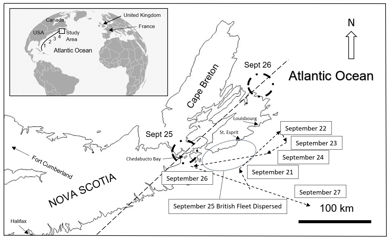
Figure 1Study location in Nova Scotia, Canada. Arrow length and orientation represents the distance and direction travelled by the British fleet on 21–26 September 1757. The records of 25 and 26 September show the path of the Invincible south of the wider dispersal of the British fleet after being scattered by the storm (dotted oval). The storm's location off New England is estimated (off map). The estimated storm track (dashed line) shows eye locations for the dates shown. The inset shows the study area relative to the North Atlantic and the hurricane track based on historic records showing its progressive northward translation seaward of (1) Florida (no date); (2) North Carolina (23 September); (3) New England (24 September); and (4) Cape Breton, Canada (25–26 September). Fort Cumberland is 70 km toward 293 azimuth.
Hurricanes are fuelled by sea surface temperatures (SSTs) over 28 °C. They rapidly lose energy as they move north over cooler midlatitude waters, and many tropical cyclones undergo extratropical transition, which releases tropical energy at increasingly higher latitudes later in hurricane season (Hart and Evans, 2001). Modern tropical cyclone intensity is characterized in real time with instruments carried by aircraft, satellites, and at ground stations. In contrast, pre-industrial metrics must be derived from historical observational records. Subjective interpretation and geographic bias can make them less reliable than instrumental data (e.g., Jones and Mann, 2004), yet they offer a temporal resolution unavailable in natural climate archives, and they straddle the end of the LIA and the rise of modern anthropogenic emissions. Oliver and Kington (1970) and Lamb (1982) first explored their suitability for weather research. Naval logbooks were subsequently found to be a superior source of historical weather data given that hourly ship observations were systematically recorded in real time with a consistent terminology. Logbook data have been compiled to assess historical atmospheric circulation patterns (e.g., Garcia et al., 2001; García-Herrera et al., 2005a; Wheeler et al., 2010; Barriopedro et al., 2014). The final report from the CLIWOC project based on a compilation of historical British, French, Dutch, and Spanish naval logbooks attempted to establish a common historical wind force terminology to document ocean surface atmospheric circulation patterns between 1750 and 1850 (García-Herrera et al., 2005b).
To date, pooled historical naval records have been used to identify longer-term regional circulation patterns and extend the multidecadal climate signal into the industrial period (e.g., García-Herrera et al., 2005a, b; Wheeler et al., 2010; Barriopedro et al., 2014). In contrast, this study takes advantage of an unusual concentration of warships in the path of a single hurricane to characterize its intensity. It seems counterintuitive that the colder LIA climate would generate more powerful midlatitude Atlantic cyclones than in the modern era, yet historical records show the LIA to be generally “stormier” with unusually powerful midlatitude hurricanes despite conditions that dampen hurricane energy. Donnelly et al.'s (2001) historic storm reconstruction from Mattapoisett Pond, Massachusetts, and Oliva et al.'s (2018) historic storm reconstruction from Robinson Lake, Nova Scotia, are among a growing number of proxy studies showing that major Atlantic cyclones struck the northeastern seaboard of North America in the LIA. Since winter extratropical cyclones known as Nor'easters cannot be differentiated from Atlantic tropical cyclones and their extratropical derivatives from proxy data alone, historical records can constrain the timing of midlatitude hurricanes and tropical storms.
This study utilizes a unique historical data set to characterize the intensity of the Louisbourg Storm using spatial and temporal weather metrics extracted from ship logbooks of both the English and French fleets, British Admiralty records and official documents of both nations, and compares the derived storm metrics to those of modern systems that tracked across the same bathymetry. Characterizing its intensity tests historical descriptions of an unusually severe storm and may help establish a more thorough understanding of LIA hurricane climatology.
2.1 Historical records
The 18th century navigation and weather data were entered hourly in the daily logs of naval vessels, resulting in reliable records suitable for historical climate research. A noon sighting of the sun fixed latitude and marked the start of the sea day. Britain adopted the Gregorian calendar in 1752, so dates in logs used for this study did not require correction. In 1757 a local meridian was used to determine longitude, deduced from logs to have been based on Louisbourg lighthouse (Fig. 2).
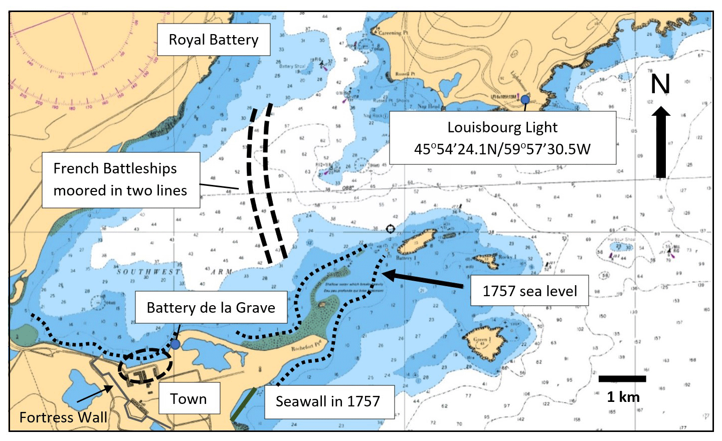
Figure 2Louisbourg Harbour showing the French fleet anchorage, Louisbourg lighthouse, Royal Battery, Battery de la Grave Guardhouse, and the southeast seawall overlain on the chart image (Canadian Hydrographic Survey Chart: Guyon Island to Flint Island with a scale of 1 : 37866, 2011). Shoals (shaded) relative to ship hull displacements of 5.8–7.6 m (19–25 ft) give a general sense of the scale of waves and surge needed to throw battleships on shore and damage the southeast facing seawall.
Historical British Admiralty Correspondence and Papers (volumes ADM 1/481, 1757a–e; ADM 1/1488, 1757 and ADM 1/2294, 1757a, b) covering storm damage to British vessels on the “Halifax Station” in 1757 and Fleet Lists (ADM 8/31, 1757; ADM 8/32, 1757) are preserved at the National Archives at Kew (UK), as are Royal Navy Master's (ADM 51/409, 1757; ADM 51/633, 1757; ADM 51/1075, 1757) and Captain's ((1757 logs contained within volumes ADM 52/578, 1757; ADM 52/819, 1757; ADM 52/1064, 1757) logbooks. Lieutenant's logs (ADM 51) kept at the National Maritime Museum, Greenwich, were often incorporated into Captain's logs with addenda. Master's and Captain's logs of the Royal Navy warships Invincible, Windsor, Sunderland, Eagle, Terrible, Grafton, Newark, Lightning, Devonshire, and Captain, plus ancillary official correspondence, were used in this study. The first author reviewed all logs and found them to be consistent in content and format, then copied letters and logbook entries written in cursive in multiple handwriting styles to a more readable format (Supplement Fig. S1). These were interpreted, compiled into a time sequence and cross referenced. Logs from French warships Fleur de Lys, l'Abenaquise, Le Tonnant, l'Inflexible, and Dauphin Royal translated from French describe conditions in Louisbourg Harbour (McLennan, 1918). Wind directions from gimballed ships' compasses reference magnetic north. Bearings and wind directions used the 32 points of the compass (Smyth, 1867; Blake and Lawrence, 1999) and were translated to azimuths. The logs of British ships at sea and French ships moored in Louisbourg Harbour contained: (1) dates and times, (2) position, (3) bearing, (4) wind direction, (5) wind speed terms that evolved into the Beaufort wind scale (e.g., García-Herrera et al., 2005a, b; Wheeler, 2005; Wheeler et al., 2010), and (6) descriptions of sea state.
2.2 Climate context
Major atmospheric circulation patterns that influence Atlantic tropical cyclone behaviour, specifically the El Niño–Southern Oscillation (ENSO) and North Atlantic Oscillation (NAO), have been reconstructed for the historical period (e.g., Gurgis and Fowler, 2009; Trouet et al., 2012). These trends provide an overarching context since La Niña years create conditions conducive to driving hurricanes in the Atlantic, and a negative NAO allows Atlantic tropical cyclones to enter the Atlantic and potentially reach the midlatitude eastern seaboard. Atmospheric circulation patterns for 1757 were studied to assess conditions were conducive to Atlantic hurricane generation.
2.3 Wind speed
Wheeler and Wilkinson's (2004) analysis of the derivation of the Beaufort scale shows terms that vary little from the logbook terms used in this study. A similar approach has been adopted here with adjectives describing primary nomenclature. A “gale” (Beaufort Force 8) was originally between a breeze (Force 2) and a violent storm (Force 11) and established a benchmark (Table 1). A “near gale”, its diminutive (Smyth, 1867) corresponds to a “moderate gale”. Wheeler et al. (2010) categorized “strong gale”, “hard gale”, “blew hard”, and “storm” as stronger than “fresh gale”. Adjectives “stiff” and “fresh” indicate winds stronger than a gale (Force 9), while a “severe” or “hard” gale reflects a “storm” (Force 10). “Excessive” and “extreme” hard gale, necessarily stronger than a “hard gale” would then correspond to “violent storm” (Force 11) which does not appear in the logs used here. “Hurricane” (Force 12) is mentioned in both French and British records. “Squall” is a historical term for an increase in wind speed sustained above threshold for at least 1 min. The National Oceanic and Atmospheric Administration (NOAA) defines it as a sudden increase by at least 16 knots (33 km h−1) and sustained at over 22 knots (41 km h−1) for 1 min. Environment and Climate Change Canada (ECCC) defines squalls as increases of 34 knots (63 km h−1) or more above prevailing winds sustained for over 1 min. The World Meteorological Organization (WMO) uses 8–11 m s−1 (29–40 km h−1) above threshold for over 1 min while the American Meteorological Association (AMA) notes squalls are of “several minutes” duration. In considering these definitions “squall” is taken to be a sudden increase in wind speed of 40–60 km h−1 above threshold and sustained for at least 1 min. We interpret “hard” squalls as the upper end of the spectrum by applying the same adjectives used to create the historic Beaufort scale (Wheeler and Wilkinson, 2004). Heavy rains accompanying squalls noted in the logs appear to be consistent with descriptions of hurricane spiral bands.
Table 1Logbook Beaufort terms and associated wind speeds (km h−1).
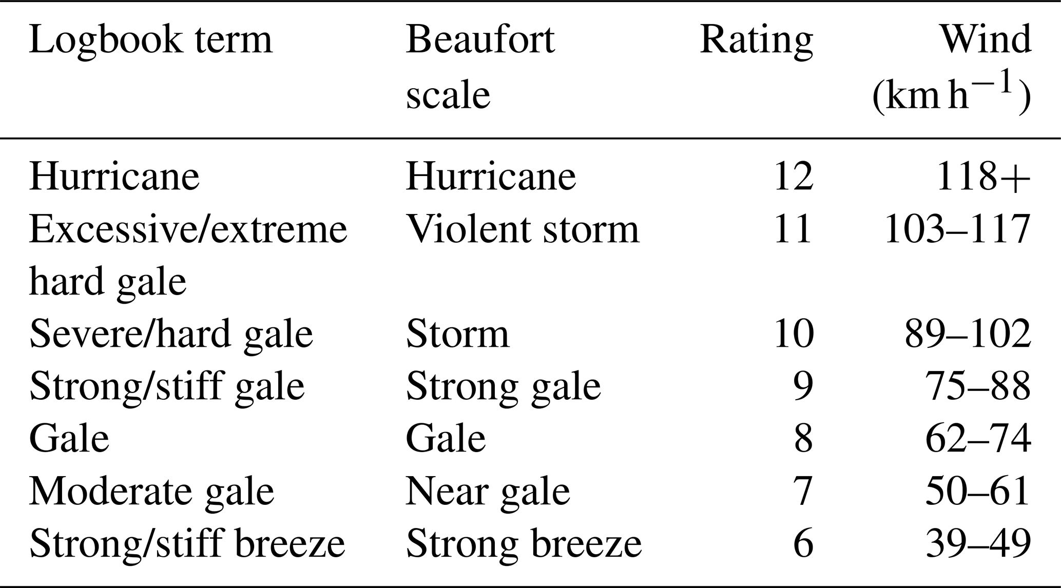
In this study the Beaufort wind force scale is used to describe wind speeds from gale to hurricane force (63–118 km h−1). The Saffir–Simpson hurricane wind scale describes hurricane winds greater than 118 km h−1 with peak wind speeds averaged over 1 min defining hurricane intensity Categories 1–5. A major hurricane is Category 3 (178–208 km h−1) or stronger. Wind speeds derived from log entries were plotted from the first southeasterlies noted off Nova Scotia on 22 September 1757 to diminishing westerlies at the storm's end on 26 September. Ephemeral squalls of 1 min duration above threshold winds provide an estimate of total wind speed sustained for 1 min or longer. Wind speeds at mid-mast height above the deck plus freeboard (distance from the waterline to the upper deck) approximate the 10 m height above ground level for modern hurricane wind speed measurements.
The 18th century navies knew hurricanes commonly encountered in the Caribbean sometimes reached North America's eastern seaboard. Since no real time wind force measurement existed in 1757, to measure and categorize hurricane intensity, this study has adopted Virot et al.'s (2016) engineering analysis of critical hurricane wind speeds that break trees as a model for estimating threshold wind speeds needed to break ships' masts. Invincible's log indicates it maintained course relative to prevailing storm winds. This placed the vessel oblique to wave crests, which minimized pitch and yaw and held masts within a stable plane of reference against which wind applied a sustained force. In addition, large vessels (74-gun third rates) with up to 2.7 m (9 ft) of flooding in the hold would have a lower centre of mass that would have affected its righting moment and minimized directional variance in the wind force striking the masts. Rigging designed to stabilize the masts and transfer wind energy through the sails would likely have required a higher sustained wind force to achieve failure.
2.4 Wind direction
Wind direction was measured using the ship's magnetic compass and entered in the ships' logs as “points of the compass”. These entries were translated to azimuths. Compass directions are relative to magnetic north and not corrected for declination given the small study area and short time frame. While 18th century navigation was inaccurate, this study benefits from (1) log entries of the fleet relying on smaller vessels sent inshore to establish distance from coastal landmarks, and (2) during the storm ships were driven sufficiently close to land that their positioning entries were based on triangulation using landmarks which greatly improves accuracy. Experienced navigators were also able to correct for ship motion in their readings while the ship's position was typically determined by a Lieutenant plus one or more midshipmen and the sailing master's mate.
2.5 Wave height
Wave height was estimated based on descriptions compared to ship dimensions and is the least accurate metric. Historic references to ship structure in Imperial units have been converted to metric. This includes the distance from the keel to the upper deck and freeboard from the waterline to the upper deck. The depth of water needed to spill over the bow to flood the upper deck and tear away large ship's boats tethered to the deck is estimated. References such as sailors being swept off spars 24 m (80 ft) above the keel offer an estimate of peak wave heights. Warships were designed for stability as floating gun platforms and to return to an “even keel” as quickly as possible after firing. Wave descriptions in Louisbourg Harbour are the least reliable since they include storm surge.
2.6 Surge
Surge is a rise in sea level due to lower atmospheric pressure and storm winds and is proportional to a tropical cyclone's intensity and translation rate. Coastal surge is a reasonable estimate of storm intensity and can serve as a test of intensity derived from wind data. The surge height of modern analogues that struck Nova Scotia after tracking across the Scotian Shelf and whose intensity has been characterized with metrics derived using modern meteorological methods provides a reliable benchmark for comparison to surge calculated for the 1757 storm. In this study, storm surge at known locations and elevations above sea level were described at (1) Battery de la Grave at Fortress Louisbourg and (2) the historic town within the Fortress (Fig. 2; Canadian Hydrographic Survey Chart 4375, 2002), and (3) St. Esprit (Fig. 1) where the British warship HMS Tilbury was stranded in water depths it could not normally navigate given its displacement. All surge calculations were then corrected for (1) relative sea level (RSL) rise since 1757 and (2) a mid-tide RSL datum used by Google Earth versus a lowest low water (tide) datum used by the Canadian Hydrographic Service for a (draft) navigation chart used for the Tilbury wreck site. In addition, French records noting the tidal change at Louisbourg allowed for the timing of the tidal cycle to be backed out to determine storm surge versus storm tide.
Tilbury's wreck site offered a chance to estimate surge at a second location 45 km southwest of Louisbourg. Tilbury's identity was confirmed in 1986 with the discovery of the ship's bell, most of its guns, anchors, and artefacts (Storm, 2002). Locating the wreck to confirm its water depth required creating a digital bathymetric chart needed to guide a marine magnetometer survey leading to site confirmation by divers.
Matthes (1939) named the LIA to explain European glacier expansion during a historically colder climate period. Heightened climate variability saw deeply cold winters and cooler mean annual temperatures primarily in the Northern Hemisphere (e.g., Kreutz et al., 1997; Mann, 2002; Jones and Mann, 2004). It may have been triggered by late 13th century volcanic eruptions and a cooling feedback process sustained by Arctic sea ice expansion (Miller et al., 2012). North Atlantic mean annual SSTs were 1–2 °C cooler than today (e.g., Keigwin, 1996; Winter et al., 2000; Richey et al., 2009; Saenger et al., 2009; Cronin et al., 2010; Bertler et al., 2011; Mazzarella and Scaffeta, 2018; Gebbie, 2019). The Maunder Minimum, the coldest part of the LIA (MM; 1645–1715), saw greater “storminess” during polar air breakouts from Europe correlating to more frequent easterly gales in the English Channel and Western Approaches in 1685–1750 (Wheeler et al., 2010). Concentrated storm horizons in coastal dunes across western Europe and in Brittany and on France's Mediterranean coast correlate to the coldest part of the LIA (Dezileau et al., 2011; Van Vliet-Lanoe et al., 2014; Sicre et al., 2016; Jackson et al., 2019). Dezileau et al. (2011) attributed LIA storminess to cold-enhanced lower tropospheric baroclinicity modifying prevailing westerlies. In the northwestern Atlantic, Donnelly et al. (2015) described major hurricane deposits in New England coastal sediments dating to 1635, 1638, and 1815. Ludlum's (1963) compilation of historical northwestern Atlantic hurricanes and tropical storms includes the LIA's major “Independence Hurricane” that struck New England on 29 August 1775 and the “Newfoundland Hurricane” of 9 September 1775, a storm that left 4000 dead to become Canada's deadliest hurricane (Ludlum, 1963; Ruffman, 1996). Lamb's (1991) exhaustive survey of British and European storms includes the Great Storm that devastated the British Isles on 26 November 1703. It was an extratropical cyclone equal to a Category 2 hurricane, yet Wheeler (2003) notes a far more powerful Atlantic storm on 1–12 December 1792, also late in the Atlantic hurricane season. Both were anomalous for a colder climate period.
The Scotian Shelf on Canada's Atlantic seaboard (Fig. 1) is dominated by the cold, south-flowing, low-salinity Labrador Current. It originates in the Davis Strait of the Canadian Arctic and hugs the coast to the start of the midlatitudes at Cape Hatteras, North Carolina, where it meets, mixes with, and redirects seaward the tropical, north-flowing more saline Gulf Stream. The Labrador Current plays a critical role in hurricane extratropical transition by providing a coastal buffer of cooler sea surface temperatures that effectively cut off the tropical energy of the Gulf Stream (Hart and Evans, 2001). Summer and fall bring warm-water eddies from the Gulf Stream and warmer coastal SSTs. Sediment cores from the Emerald Basin off Nova Scotia show 1600 years of cold Labrador Current temperatures and a sudden and sustained warming around 1850 that has continued into the present (Keigwin et al., 2003) and coincides with the end of the LIA. Storm compilations by Landsea et al. (2004) and Chenowith (2006) show a progressive increase in the number of historical Atlantic tropical cyclones from 1700 and a sharp increase in the number and percentage reaching New England and eastern Canada beginning around 1850. Vecchi and Knutson (2008) in a study of data from the start of instrumental data collection in 1880 show a strong correlation between mean annual SST and storm frequency.
Historical records offer seasonal weather detail not captured by annual to multidecadal proxy trends. Anomalous midlatitude coastal sea surface temperatures (SSTs) over days to weeks, conditions that fuel tropical cyclones, are therefore not likely to appear in annualized data weighted by colder, sustained LIA winters. Northern and Arctic temperature reconstructions for temperate North America show cooler mean temperatures over the whole of the LIA (e.g., Jacoby and D'Arrigo, 1989; Trouet et al., 2013). Trouet et al. (2013) demonstrate a multi-decadal warming to cooling trend peaking in the mid-18th century.
Lieutenant John Knox recorded unusually high temperatures in Halifax Harbour on 20 July 1757, which fellow officers found hotter than Gibraltar and the Mediterranean (Knox, 1769). This coincided with a heat wave in Britain and southwestern Europe from July into early August 1757 that set temperature records that stood for over 250 years (The London Chronicle, 1757; London Magazine, 1758, pp. 563–564). London on 16–26 July had an average high of 41.2 °C (Nature Notes, 1882, p. 415). This does not assume weather conditions in Europe fuelled a hurricane tracking into Atlantic Canada but demonstrates that unusually hot temperatures across the Northern Hemisphere capable of warming midlatitude SSTs that intensify midlatitude hurricanes existed in the summer of 1757.
The 1757 hurricane noted by Poey (1855) and Ludlum (1963) was confirmed as a hurricane, storm 73 in Table IV in Chenowith's (2006) re-assessment compilation. It was first seen off Florida and followed the coastline past Cape Hatteras to New England on 22–24 September (Ludlum, 1963). Benjamin Franklin's observations of this specific storm led him to conclude that hurricanes “are produced by currents of cold winds rushing from the north along the Atlantic coast and mingling with the warm winds produced by the gulf-stream” (Warden, 1819). It struck the British frigate HMS Winchelsea on 23 to 24 September at 36°45′ N, 70°54′ W (off North Carolina over the Gulf Stream). The log notes gale force east then east-southeast and south winds between 22:00 and 05:00 on 23–24 September, which 15 min later veered violently to the northeast and then northwest at “near hurricane” intensity. It split the main sail and broke the main mast and was accompanied by a “great sea” (ADM 52/1105, 1757).
The storm passed New England on 24 September (Boston News-letter, 1757; Ludlum, 1963) and struck Nova Scotia as the Louisbourg Storm on 25 September 1757. Its arrival at Fort Cumberland on the Nova Scotia border 200 km inland by late 22 September included “violent rain” and “constant heavy rain” into 23 September. Knox's journal on the 27 September describes 24–26 September with … “I never saw such storms of wind and rain as we have had for some days past …” followed by “windy, showery and very cold” weather on the 27–28 and `dry, cold windy weather” on 29 September, followed by frost and snow across Nova Scotia by mid-October (Knox, 1769).
The Seven Years' War (1756–1763) arose from unresolved issues following the Treaty of Aix-la-Chappelle that ended the War of the Austrian Succession (1740–1748). It began as a European conflict between Great Britain and its allies and France and its allies, but soon extended to the colonial interests of both nations in North America and India (Corbett, 1907). It resulted in significant losses for France, including the loss of New France, now Canada, to Great Britain (Syrett, 2008). Britain's overwhelming success in gaining territory at France's expense during the war led France to subsequently support the secession of the American colonies in 1775.
Great Britain's “Grand Plan” for the North American campaign began with John Campbell, the 4th Earl of Loudoun, being appointed Commander-in-Chief of the British military in North America. His adversary was Louis-Joseph de Montcalm-Grozon, Marquis de Montcalm de Saint-Veran, commander of French forces in North America. To attack Montcalm at Quebec without leaving a powerful French fortress at his rear, Loudoun needed to first seize Fortress Louisbourg in Nova Scotia (Corbett, 1907). On 22 to 25 May 1757, troops boarded 134 transport ships escorted by warships under Commodore Charles Holmes (ADM 1/481, 1757a) in New York to rendezvous at Halifax with a fleet departing Britain under Vice Admiral Frances Holbourne. Pitt's brief removal as Prime Minister delayed the fleet but his return to power with a coalition government saw it depart Cork, Ireland, on 8 May 1757. The delay allowed France to reinforce Louisbourg with three naval squadrons ahead of the British arrival. On 23 May, five French battleships and a frigate under Chevalier Joseph de Beauffremont arrived from the West Indies, followed on 15 June by four battleships and two frigates under Joseph Francois de Noble du Revest from Toulon. On 20 June nine battleships and two frigates under Vice Admiral Emmanuel-Auguste de Cahideuc (Comte Dubois de la Motte) arrived from Brest. A total of 4000 French troops bolstered a garrison of 3200 plus 300 Acadians and Mi'kmaq warriors (McLennan, 1918; Stoetzel, 2008). Holbourne's arrival at Halifax on June 30 bolstered Loudoun's force to create an army of 12 000. HMS Gosport arrived on 5 August with letters intercepted from a French schooner captured off Newfoundland detailing Louisbourg's reinforcement. It rendered the attack on the fortress untenable (Knox, 1769). Loudoun returned to New York, and on 11 September 1757 Holbourne sailed his fleet (ADM 8/31, 1757; ADM 8/32, 1757) north to blockade Louisbourg (Fig. 1).
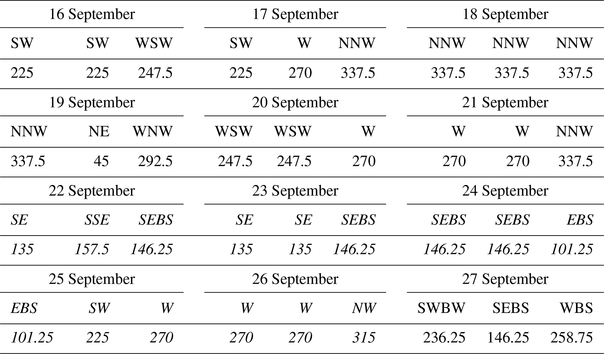
The British fleet cruised off the coast of Cape Breton Nova Scotia (Fig. 1) to lure the French fleet out of Louisbourg Harbour to do battle. On 21 September, the British 80-gun flagship Newark noted fresh westerly gales followed by fair weather and light breezes then calm with fog on 22 September (ADM 51/633, 1757). That day an officer on the French 28-gun frigate Fleur de Lys saw a low mist enter Louisbourg Harbour (McLennan, 1918). The mist was also seen at sea by the British Invincible until it dissipated under a rising southeast breeze (ADM 51/471, 1757). Britain's Newark (ADM 51/633, 1757) and France's Fleur de Lys recorded that the breeze veered to the southeast and intensified to moderate gales on 22 September. The Invincible recorded strengthening easterlies 22–26 September (ADM 51/471, 1757) from otherwise prevailing westerlies through the second half of September (Table 2). Table 3 summarizes the timing of the storm impact on the British fleet cruising offshore and on the coast near Louisbourg and the French fleet in port.
Table 2Prevailing wind direction measured for each of three successive 8 h watches per day and azimuth equivalent on the Invincible (ADM 51/471, 1757). Storm winds, arriving 22 September 1757 off Cape Breton, are in italics; two watches show easterlies not associated with the storm not in italics, the mean 250.5 (WSW) prevailing wind direction 6 d before and 5 d following storm (continued westerly on 28 and 29), and the mean 135 (SE) wind direction during the storm. Ships off St. Esprit on 25 September saw prevailing southeasterly winds last until 26 September. Ships south of St. Esprit including Invincible, Sunderland, and Windsor faced southwesterly winds on 25 September. Winds at Invincible's location shifting through SW–W–NW September 25–26 are hurricane winds (italics). “B” stands for “by”, a historical modifier defining a point of the compass (e.g., SWBW means southwest by west which is 11.25° west of southwest or 236.25 azimuth).
French naval officers, expecting a storm due to the southeast winds, moored the French fleet in two lines off Royal Battery (Fig. 2; McLennan, 1918) with four 2 t anchors set from the bow of each ship with four 20 cm diameter anchor cables. The southeasterly winds led the British ships at sea to secure topgallant masts and naval guns weighing as much as 3 t apiece, anticipating a storm. On 24 September, Invincible and Newark reported increasing cloud, haze, and rain beginning under southeast gales (ADM 51/471, 1757; ADM 51/633, 1757).
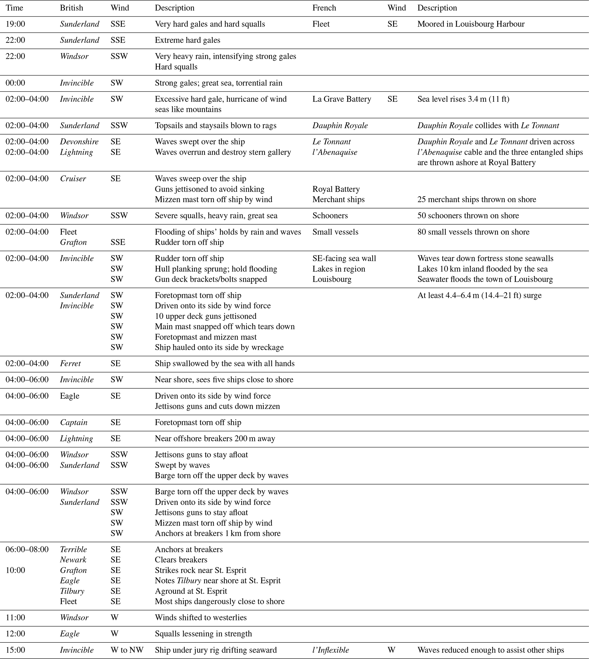
On 25 September fresh southeast gales rose to excessive hard gales with very heavy rain. The British Windsor noted heavy rain and mist and intensifying strong gales with hard squalls (ADM 51/1075, 1757). At 19:00 Sunderland faced very hard gales that rose to extreme hard gales by 22:00 (ADM 51/921, 1757). At 00:00 Invincible faced strong gales, torrential rains and a “great sea”. At 02:00 on 25 September Invincible noted an “excessive hard gale” and “a hurricane of wind” and mountainous waves (ADM 51/471, 1757). Topsails used to control ships in severe weather were “blown to rags”. Sunderland's main staysail was torn away. Waves “made a free passage over …” the 70-gun Devonshire and smashed into and damaged Lightning's stern (ADM 51/537, 1757; ADM 52/570, 1757). The wind tore away the 8-gun Cruiser sloop's mizzen mast and three sailors were swept overboard. Cruiser was “very near foundering having been underwater several times” (description by Captain Palliser of HMS Eagle) and jettisoned its guns to stay afloat (ADM 1/2294, 1757a).
Windsor's log records extreme gales with severe squalls, heavy rain and a great sea. Canvas tarpaulins stripped off deck gratings by the wind allowed waves and rain to flood the ships which soon had up to 2.5 m (9 ft) of water in the holds despite the pumps in full operation. Windsor and Sunderland sailed S across SSW winds (ADM 51/921, 1757; ADM 51/1075, 1757). Grafton's 3 t 7 m (30 ft) rudder was torn off the ship (ADM 51/409, 1757). Invincible's rudder, also torn free, was only saved by its preventer chains (ADM 1/2294, 1757a). Sails on all the British ships at sea were torn away by the wind. Captain Bently later reported that Invincible's hull planking had opened and that strain on the hull broke iron reinforcing brackets and bolts, allowing the entire gun deck and its tens of tons of heavy naval guns to drop several inches (ADM 1/1488, 1757). Sunderland's foretopmast, reinforced by 10 total 5 cm (2 in.) rope shrouds plus stays, was torn off the ship, and it disappeared into the night with two sailors (ADM 51/921, 1757). Invincible was thrown onto her “beam ends” (side), forcing it to heave overboard 10 total 12-pounder upper deck guns and carriages, roughly 20 t, to right the ship. Invincible's main yard was ordered taken down but before it could be done the wind broke off the 38 in. (1 m) diameter mainmast 20 ft (6 m) above the deck. The falling mast tore down the foretopmast and mizzen mast and crushed the starboard gunwale. The wreckage pulled the ship onto its side and swept sailors John Guttredge and Samuel Kirby into the sea. Invincible's sailors cut the tangled mass free before it sank the ship (ADM 1/1488, 1757; ADM 1/2294, 1757a, b).
At Louisbourg, the French military officer at La Grave Battery (Fig. 2) led his troops to safety after the sea rose steadily above their knees (Johnstone, 1758). Offshore, the British 14-gun Ferret sloop under Francis Upton and a crew of 125 was lost with all hands (ADM 1/481, 1757c). Around 06:00 Invincible noted five British ships dangerously close to shore. Eagle was blown onto its beam ends and jettisoned 10 upper-deck guns and cut down its mizzen mast to right the ship (ADM 1/2294, 1757a). Captain's foretopmast was torn away and took its two topmen (ADM 52/819, 1757). Lightning found it was drifting toward offshore breakers less than 200 m away (ADM 51/537, 1757). Captain Faulkner ordered Windsor's guns jettisoned. He noted Invincible had lost all but its lower foremast and bowsprit (ADM 51/1075, 1757). Sunderland was swept by “a very heavy large sea” that “passed freely over us” (ADM 51/921, 1757). Barges lashed to the decks of Windsor and Invincible were smashed and swept overboard (ADM 51/1075, 1757; ADM 1/1488, 1757; ADM 51/471, 1757). Sunderland cut down its main topmast and threw guns overboard to right the ship. The wind snapped its 61 cm (24 in.) diameter mizzen mast as it drifted toward the offshore breakers. Anchors did not slow its drift so the mainmast was cut down. Sunderland stopped close to the breakers and less than a kilometer from shore (Fig. 3; ADM 51/921, 1757). The 74-gun Terrible also stopped its drift almost at the breakers. Eagle's foretopmast was cut down to lessen the strain on the ship (ADM 52/578, 1757). It sailed southward narrowly missing the breakers (Fig. 3). Newark regained control after cutting the anchor cable and heaving guns overboard and barely cleared the line of breakers (ADM 51/633, 1757). Dawn revealed a signal flag had been raised by the French fishing village of St. Esprit to give the crews of the British ships hope (Farley, 1757).
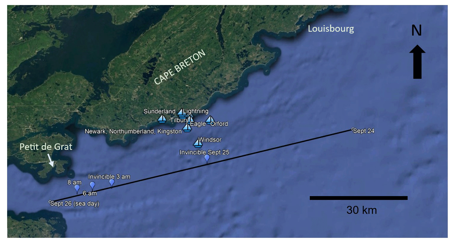
Figure 3Location of British ships estimated for 08:00 LT 25 September (sea day). The fleet sailed in close formation until scattered by the hurricane south of Louisbourg (Fig. 1). Named ship locations reflect best estimates of ship positions based on logbook references to sightings and estimated distances and bearings to the coastline, known islands, Louisbourg, the breakers at St. Esprit and other ships. The displacement of Invincible is based on the ship's logbook entries for 24 September where the ship's position was fixed at noon with sextants to establish latitude with the sun highest in the sky marking the start of the sea day. The entry 45°36′ N, 0°12′ E, correcting for 12′ E longitude relative to Louisbourg Lighthouse as the zero meridian, corrects Invincible's position to 45°36′ N, 59°45′ W. Invincible's position on 26 September based on a bearing of NBE (11.25 azimuth) and 4 miles (5 km) from “Peddigrah”, a phonetic spelling for “Petit de Grat” gives 45°23′51′′ N, 60°58′55′′ W. Sunderland halted its drift 1 km from shore when the anchor finally held. The southwesterly winds encountered by Invincible, Sunderland, and Windsor reflect the southernmost vessels sailing southwest into a northeast tracking storm. A displacement of 97.25 km toward 257.43 azimuth is seen when the bearing was taken at 11:00 LT when the wind shifted to westerly (25 September; sea day), giving an average speed of 2.07 km h−1 over 47 h. Plotting the hourly displacement allowed the position of the ship to be estimated for noon on 25 September, at the height of the storm at 03:00 LT, when the ship was dismasted at 06:00 LT, and at 08:00 LT when the positions of multiple ships could be estimated when Windsor, Sunderland, and Invincible were under southwesterly winds while the rest of the British ships were still recording south-southeasterly winds and when the British ship positions had been stabilized by anchoring or limiting their rate of drift. Logbook records: Orford 6 km from the coastline running northwest to north; Windsor 3 km from the breakers; Terrible 1.3 km from breakers and 3 km from the land to the west-northwest (ADM 52/1064, 1757); Lightning 200 m off the breakers before halting its drift; Sunderland 1 km from shore after sailing SE across SW winds; Tilbury shoreward of the breakers; Newark near the breakers with Northumberland and Kingston and Windsor (ADM 1/481, 1757a, b); Eagle south of the breakers until 11:30 LT when the breakers were 3 km to their lee. Image © Google Earth Pro 7.3.6.9345 (2022) Cape Breton, Nova Scotia, Canada. Image date 13 December 2015; 45°33′51.38′′ N, 60°13′56.57′′ W; eye altitude 132.12 km; TerraMetrics © 2023, MaxarTechnologies © 2023.
At Louisbourg the French fleet was pummelled by severe winds and waves. The 70-gun French battleship Dauphin Royale fired a gun in distress when its anchor cables snapped under the strain. Dauphin Royale collided with the 80-gun Le Tonnant, destroying its bowsprit, figurehead, and cutwater, and damaging Le Tonnant's rudder and poop deck. The two ships crossed l'Abenaquise's anchor cables and the three entangled ships were heaved on shore at Royal Battery (Fig. 2) along with 25 merchant ships, 50 schooners, and 80 small vessels, many high and dry and with many sailors drowned (this is noted in Felix Farley's Bristol Journal) (Farley, 1757; McLennan, 1918).
At sea, by 10:00 the British fleet was dangerously close to the breakers off St. Esprit. Many sailors were certain they were doomed based on later descriptions of sea conditions reported to the newspapers back in England (Farley, 1757). Grafton struck a rock but floated free and managed to set an anchor. Windsor and Eagle had been able to sail south of the main British fleet off St. Esprit. Eagle's Captain Palliser saw what he judged to be Nottingham or Tilbury near the shore, within the breakers, its bow facing shore with its fore and mizzen masts gone (ADM 1/2294, 1757a). He also recorded that it was afloat and attempting in wear (turn) but lost sight of it in heavy rain. Eagle was later taken in tow to clear the shore by HMS Defiance and sailed for England (ADM 1/2294, 1757b).
Waves tore down sections of the French Fortress Louisbourg's massive southeast facing stone seawalls. Locals brought news of lakes 10 km inland being reached by the sea. Seawater rose to flood the streets of the Town of Louisbourg, “something never before seen” (Johnstone, 1758). Eventually the beached French battleship Le Tonnant “floated with the tide” as the wind veered south and then west at 11:00.
At sea the British warship Windsor noted the wind turned to blow from the west at 11:30 but had strengthened. Eagle recorded that the squalls had lessened by noon (ADM 52/578, 1757). On the Sunderland massive waves swept sailor George Lancey from the fore yard 24 m (80 ft) above the keel (ADM 51/921, 1757). By 15:00 waves at Louisbourg fell enough that l'Inflexible was able to send sailors to assist other ships. French captains petitioned 74-year-old Admiral Dubois de la Motte to attack the stricken British ships off their coast but his orders to defend Louisbourg had been met and he kept his ships in port. James Johnstone, a Scot serving as a French officer, felt that five French warships if they had ventured to sea could have captured the entire British fleet (Johnstone, 1758). This sentiment was subsequently shared by Lady Anson, daughter of a confidante of Lord Newcastle with whom Pitt had formed his coalition government, in an 31 October 1757 letter to the First Lord of the Admiralty, her husband George Anson (Lady Anson, 1757). On 27 September a boat arrived at Louisbourg from St. Esprit with news that the British warship Tilbury had wrecked there with over 120 lost. Four schooners with 160 French troops were unable to counter the heavy seas so they marched to the site across land flooded by the torrential rain. Mi'kmaq warriors gained the wreck first but informed the shipwrecked British they would not be harmed since the storm had brought them to their lands (McLennan, 1918). Holbourne gradually received news of the extensive damage to his fleet and drafted letters to the Admiralty describing the “shattered” condition of the ships and that he was sending many on to Newfoundland and Labrador and to England for repair (ADM 1/481, 1757a–e). Captain Palliser of the Eagle informed Holbourne that he was proceeding directly to England due to the damages his ship had received (ADM 1/2294, 1757b). A summary of the timing of storm impacts on the British fleet at sea and on the coastline near Louisbourg and on French ships in harbour is presented in Table 3. It is not known when the Ferret was lost with all hands, but it had been sent ahead of the British fleet to reconnoiter Louisbourg immediately prior to the storm.
Table 3Timeline of Louisbourg Storm (25 September). Timeline of storm impacts on the British fleet at sea increasingly scattered by the storm and the French fleet moored in Louisbourg Harbour. British ships were relatively static (drifting, sailing under reefed sails, or at anchor) but Invincible sailed across storm winds to end up south of Windsor and Sunderland. It is not known when Ferret sank but it had been sent ahead of the fleet prior to the storm to undertake reconnaissance of the French fleet at Louisbourg.
Storm intensity is reflected in key metrics including wind speed and direction and wave height and surge, which is driven by a rise in sea level due to atmospheric pressure and sustained storm winds and is proportional to a cyclone's intensity and translation rate and the bathymetric gradient of the continental shelf.
6.1 Estimating storm wind speed
The wind speed required to break Invincible's main mast, and other ships' mizzen masts and topmasts is estimated based on the engineering model of Virot et al. (2016), who determined the critical wind force needed to break trees of average integrity is 151 km h−1 irrespective of species with a +9 % factor for large diameter trees. This is relevant since masts in 1757 were made from single trees; 165 km h−1 assumes that structural defects due to longer tree life offset the structural advantage of size, yet masts were chosen for their lack of defects. Fir and pine trees of superior structural integrity were selectively harvested for Royal Navy masts into the 1770s from North America, Great Britain, and the Baltic (Lavery, 1984). Masts were also not free-standing (like trees) but reinforced by rigging to effectively transfer wind energy from the sails to the hull. Invincible's masts were secured by 16 total 5 cm (2 in.) hemp shrouds per side, each tensioned with paired deadeye blocks, the lower block in an iron band bolted to the ship's frame. Its 1 m (38 in.) diameter lower mainmast stepped against the ship's keelson rose 35.7 m (117 ft) through two decks. Above it stood a 21.3 m (70 ft) 51 cm (20 in.) diameter topmast and above that the 10.7 m (35 ft) 28 cm (11 in.) diameter topgallant mast (Lavery, 1984, 1988).
Invincible sailed SW under SE winds (Fig. 5) but gradually encountered SW winds. Sunderland and Windsor sailed south across SSW winds while most ships of the British fleet to their north near St. Esprit faced SSE winds. Invincible was among the southernmost ships (Fig. 1). It sailed SWW (230°) against EBS (101°) winds on 24 September. During the storm its displacement was 98 km toward 256.7° (22.5 km S; 96 km W). At 4 km SW (135°) of Petit de Grat it faced W (270°) winds.
Ephemeral squalls of 40–60 km h−1 added to sustained winds of 165 km h−1 suggest peak winds might have reached 205–225 km h−1 around 06:00 when Invincible's mast broke. Sunderland's foretopmast broke at 07:00, and the mizzen mast broke at 09:30. While it is an imperfect solution, it does not consider the inherently superior structural integrity of masts plus their reinforcement by rigging, which requires only an additional strength factor to withstand an additional sustained 13 km h−1 to meet major hurricane threshold (178 km h−1) without considering squalls.
Anticlockwise wind vectors at ship locations are tangential to concentric cyclonic wind bands. Normal lines drawn to these vectors converge to identify the location of the eye. Interestingly they lack the asymmetry diagnostic of extratropical cyclone wind fields (Fig. 8). This process, repeated to plot the eye location on 26 September 1757, indicates the storm crossed Cape Breton and entered the Gulf of St. Lawrence. Even if the wind field began to collapse, the location of the storm centre suggests the system may have slowed while passing over Cape Breton Island.
6.2 Estimating storm wave height
Sunderland's and Devonshire's upper decks were submerged after waves broke over the forecastle. The 12.2 m (40 ft) distance from the keel to the upper deck plus an estimated 3–6 m (15–20 ft) to break over the forecastle and tear away ship's boats lashed to the deck requires a wave height of about 18 m (60 ft) (Lavery, 1983). Lightning's stern gallery 15–20 m (40–50 ft) above the keel was destroyed by waves striking the ship from astern, also requiring waves of about 12.2 m (60 ft). A sailor swept out of Sunderland's fore yard by a wave suggests a wave of about 25–30 m (80–90 ft). While carrying considerable uncertainty, these examples provide estimates of significant and maximum wave heights. Waves sufficiently large to tear down stone seawall ramparts of Fortress Louisbourg are consistent with these estimates, as are waves capable of reaching inland lakes. Descriptions of the sea state in Louisbourg Harbour by French naval officers resulting in extensive damage to ships and boats suggest waves much larger than any recorded in modern times even though wave energy from the southeast would have been partly attenuated by shoals (Fig. 2).
On 26–28 September 1818, the American frigate USS Macedonian met a hurricane off Bermuda (35° N, 53° W) and suffered damage nearly identical to HMS Invincible in 1757 from waves of 12 m (40 ft) (Saegaesser, 1970). The dates appear to coincide with Chenowith's (2006) `Final Storm Number 253' listed as a hurricane in Chenowith's Table IV. Damage to the ship closely parallels that described for the 1757 hurricane except that line of battle ships had a much heavier construction than a frigate. Saegaesser (1970) provides a detailed account from the ship's log and ancillary damage reports and notes that in the same storm the Dutch brig De Hoope lost all topmasts and spars, the brig Ann from Nova Scotia was abandoned at sea, the brig Mary from Bristol was overturned, the ship Catherine Dawes from Philadelphia sank, and a Baltimore schooner and a Nantucket whaler were both dismasted. Invincible's substantially more robust build than the frigate Macedonian implies more intense storm conditions.
6.3 Estimating surge height
6.3.1 Surge at Louisbourg Harbour
A Parks Canada coastal erosion study at Fortress Louisbourg National Historic Site revealed iron mooring rings set in the remains of a seawall. Modern high tide compared to these rings established historical high tide 0.90 m (3 ft) of sea level rise since 1757 (Duggan, 2010). La Grave Battery (Fig. 2) is 2.0 m (6.6 ft) above sea level (asl; Google Earth mid-tide datum), so sea level rise plus flooding to sentries' knees (0.5 m) yields a 3.4 m (11 ft) mid-storm surge. Historic buildings along the waterfront (Fig. 2; 45°53′33.57′′ N, 59°59′07.89′′ W) are 5 m (16.4 ft) a.s.l. (above sea level) while the first street, Rue Royale, is 7 m (22.9 ft) a.s.l. Seawater flooding the town streets at the lowest levels and adjusted for sea level rise indicates 5.9 m (19.4 ft) to 7.9 m (25.9 ft) of surge. The Fleur de Lys noted that Le Tonnant “floated with the tide” when the wind veered south at 11:00 on 26 September (McLennan, 1918). Louisbourg's 12 h tidal cycle and assuming low tide around 10:00 gives a high tide at 04:00 coinciding with storm landfall and creating a storm tide (Fig. 4). Backing out the 1.5 m (5 ft) tidal range gives a 4.4–6.4 m (14.4–21 ft) peak surge, consistent with the earlier surge of 3.4 m (11 ft) at La Grave.
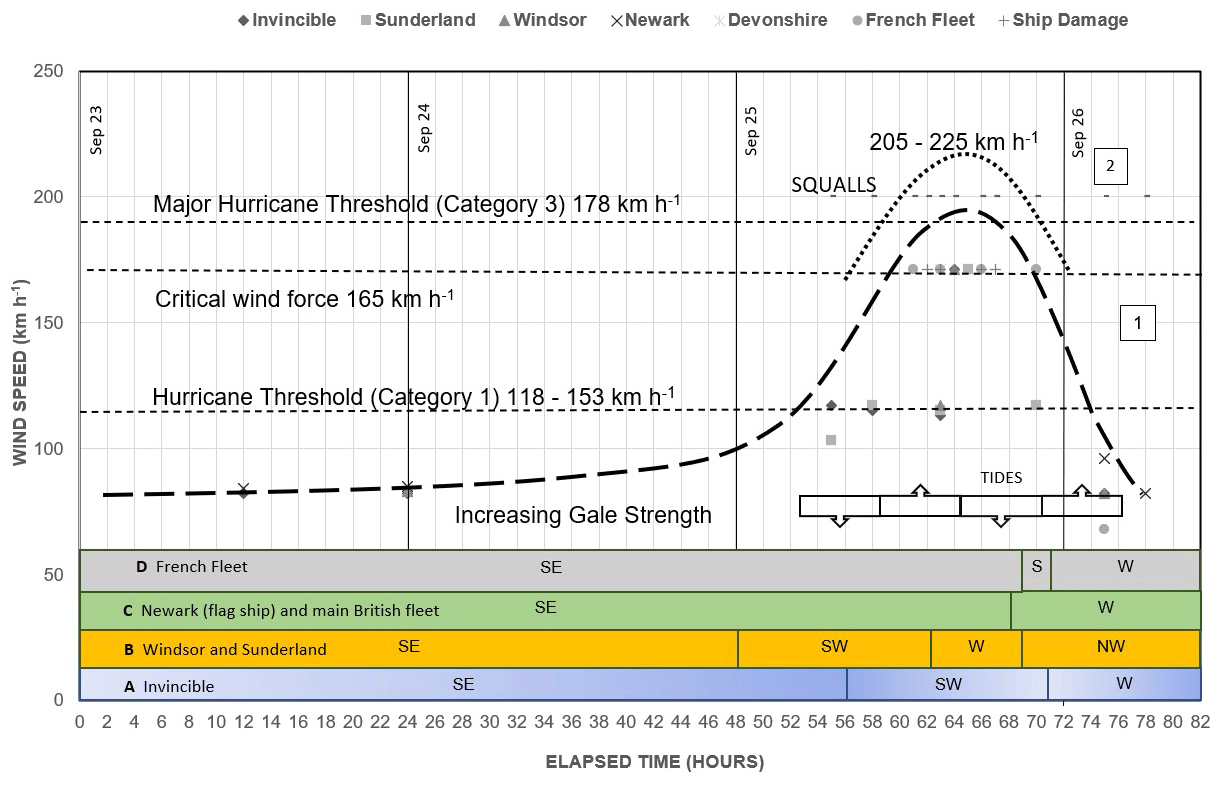
Figure 4Hurricane wind evolution with time. The time sequence shows the arrival of southeast winds (Beaufort Scale) intensifying to hurricane winds (118 km h−1) peaking at sustained 165 km h−1 critical wind force with increasing squall frequency, followed by a rapid decline to gale force westerlies. The horizontal axis is divided into days (noon) and 2 h intervals. The vertical scale is wind speed (in km h−1). A best-fit curve (1) is typical of wind speeds as a hurricane passes a fixed point. A best-fit curve for squall frequency (2) in ships' logs adds ephemeral wind speed to sustained winds; 165 km h−1 is considered the minimum critical wind force considering the superior materials integrity of masts and their reinforcement with rigging. Peak winds lasted 9 h, while hurricane force winds impacting the fleet lasted 15 h. Wind directions represent, north to south, winds affecting French ships at Louisbourg, British ships near St. Esprit, Windsor and Sunderland south of St. Esprit, and Invincible closest to the eye (Fig. 1). Southernmost (blue) through southern (orange) off St. Esprit (green) and Louisbourg (grey) show the general distribution of ships. Invincible sailed south past Windsor and Sunderland during the storm.
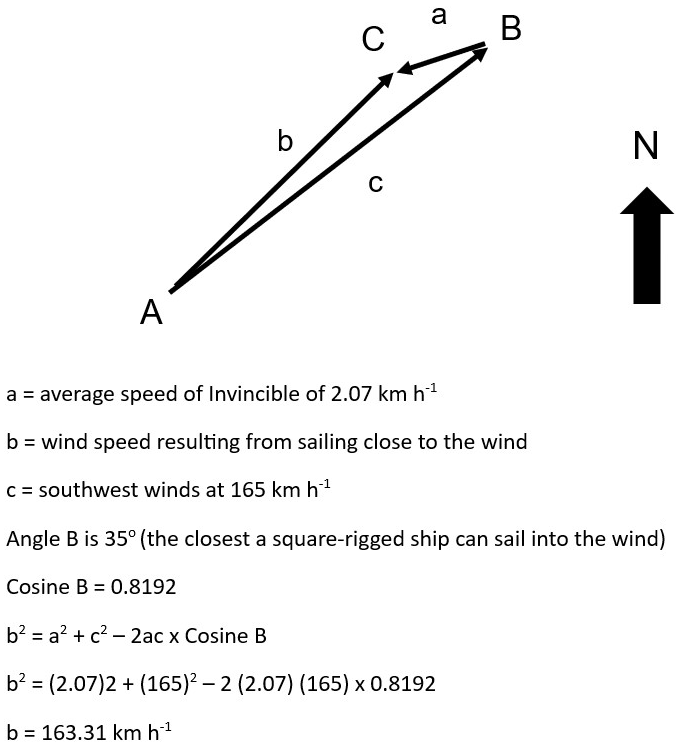
Figure 5Estimate of wind force at Invincible under threshold winds. Invincible, maintaining its bearing of SWW of 24 September, sailed into winds that progressively became SW (at the ship) as the hurricane tracked northeast. Square-rigged ships cannot sail closer than 35° into the wind. This reduced the wind speed acting on the masts by a minor amount, suggesting that squalls whose frequency corresponds to the frequency of ship damage (Fig. 4) were needed to overcome the reinforcing factors of superior mast structural integrity and rigging to achieve critical force. Not to scale.
6.3.2 Surge at St. Esprit (Tilbury Wreck)
HMS Tilbury was a 58-gun square-rigged warship lost on the coast in the storm. Eagle's captain saw either Tilbury or Nottingham shoreward of the breakers near St. Esprit, 45 km south of Louisbourg. It was deduced to have been Tilbury since Nottingham survived the storm with a different array of masts than seen on this ship. “Wreck” appears on a 1776 chart (Fig. 6). Storm (2002) used Zinck's (1975) image of an 18th century 6-pounder British naval gun at “Tilbury Rocks” to view Tilbury's wreckage in 4 m (15 ft) water from a boat in 1969.
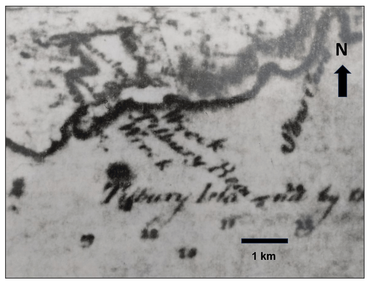
Figure 6Excerpt from a historic chart of Cape Breton Island showing the general St. Esprit study area and HMS Tilbury wreck site, from Mowat (1776), depicted in Fig. 7a and b. The faint dotted line right of Barnsley Lake, named for Tilbury's captain, marks a parish boundary that remains today as a fieldstone wall.
The historic navigation chart (Fig. 6) showed parish boundaries marked by fieldstone walls of historic St. Esprit (Fig. 7a, b) which helped identify the line of offshore breakers described in British naval logs. A 1954 scale paper draft hydrographic chart was digitized and gridded with missing data interpolated. Paired depths and locations were entered in a spreadsheet, and a grid plot of local bathymetry supported a marine proton magnetometer survey of Tilbury Reef isobaths following best practices for submerged archaeological sites (Cornwall Council, 2010) and respecting sovereign protection of the site (British High Commission, 2006). Dipole targets investigated by divers led to locating a mid-18th century 6-pounder British naval gun in situ in 3 m (10 ft) water which was 2.1 m (7 ft) in 1757, near the site of the 6-pounder on shore, both interpreted to be from Tilbury's forecastle. In 1757 Tilbury was observed at the time as “bow in” near shore, landward of the breakers and “attempting to wear” (turn). It was in water sufficiently deep for its 18 ft displacement as it was, at the time, afloat and under sail. Adding in the hydrographic survey datum offset of 0.6 m (2 ft) between lowest low tide at St. Esprit and the Google Earth WGS84 (World Geodetic System, 1984) mid-tide datum for Louisbourg suggests a minimum 4.0 m (13 ft) surge at St. Esprit. Post-storm relaxation flow stranded the Tilbury (Fig. 7b), allowing native warriors to reach it.
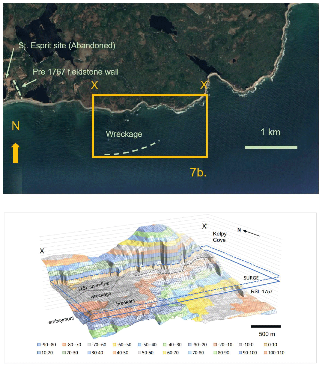
Figure 7Location of the Tilbury shipwreck (7a) showing inset map X–X′ (45°38′31.21′′ N, 60°27′41.99′′ W to 45°38′31.61′′ N, 60°26′05.28′′ W) corresponding to the bathymetric chart (7b). The dashed line is bedrock reef (breakers). Bathymetry of the Tilbury wreck site is at lowest low water adjusted for 1757 relative sea level (solid line) and minimum surge (dashed line) needed to float Tilbury. Coastal retreat of 27 m (90 ft) calculated from historic sea level gives the 1757 shoreline. Topographic and bathymetric data were kept in imperial units (feet) for comparison to Tilbury's displacement. X and X′ of this block diagram correspond to the same GPS positions noted. Image © Google Earth Pro 7.3.6.9345 (2022), St. Esprit, Nova Scotia, Canada; 45°38′31.54′′ N, 60°27′37.76′′ ; eye altitude 4.50 km; TerraMetrics © 2023, MaxarTechnologies © 2023.
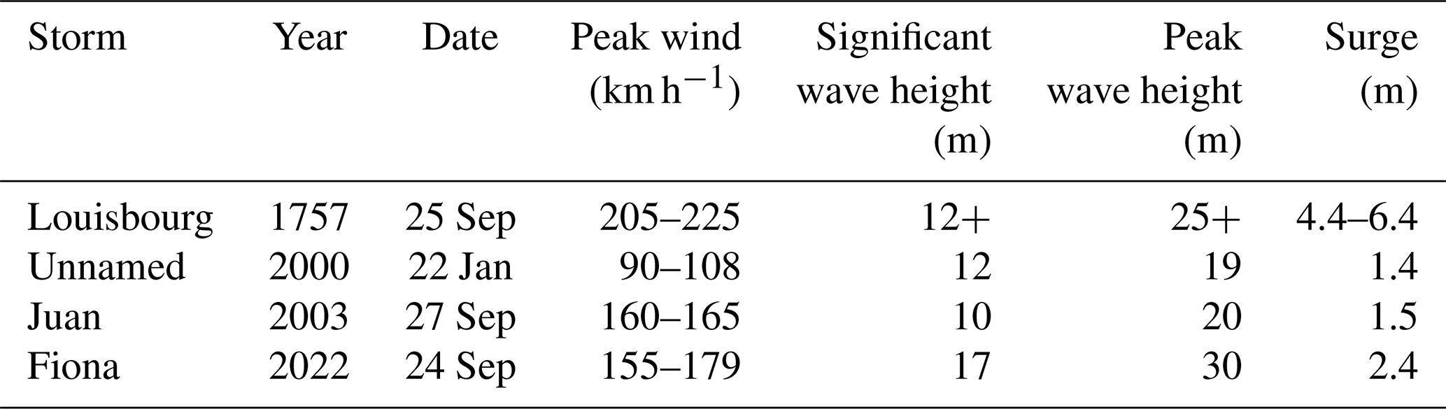
On 29 September 2003, Hurricane Juan struck Nova Scotia with peak winds of 165 km h−1 (Category 2), a significant wave height of 10 m (32 ft), a maximum wave height of 19.9 m (65 ft) and a surge at landfall near Halifax of 1.5 m (4.9 ft) (Avila, 2003). On 20–22 January 2000, an extratropical meteorological “superbomb” that developed off Cape Hatteras struck Nova Scotia with peak winds of 25–30 m s−1 (90–108 km h−1), a significant wave height of 12 m (39 ft), a peak wave height of 19 m (62 ft) to 23 m (77 ft) at drilling rigs near Sable Island (John Dickie, 22 January 2000, on the Galaxy II drilling rig) and a 1.4 m (4.6 ft) surge at landfall near St. Esprit (Lalbeharry et al., 2009). Both cyclones produced similar sea states and surge that can be compared to the Louisbourg Storm. On 24 September 2022, Category 3 Hurricane Fiona began extratropical transition as it crossed the Scotian shelf. A cold trough over Nova Scotia directed its landfall to the Canso Peninsula. Winds of 140 km h−1 in Nova Scotia reached 177 km h−1 in Newfoundland and Labrador. Significant and maximum wave heights were 17 m (56 ft) and 30 m (98 ft), and surge reached 2.4 m (8 ft).
In 1969 Category 5 Hurricane Camille generated a 7.3 m (24 ft) storm tide from 1.8–3.0 m (6–10 ft) surge (US Department of Commerce Environmental Science Services Administration Weather Bureau, 1969), while Category 5 Katrina in 2005 produced a storm tide of 8.2 m (27 ft) (Knabb et al., 2023). Hurricane Laura (Category 4) in 2020 had a peak 5.2 m (17.2 ft) surge (Pasch et al., 2021) and a 2.7–4.0 m (9–13 ft) surge spanning 130 km from Beaumont to Lake Arthur, Texas. In 2018 Hurricane Dorian (Category 5) slowed to 2 km h−1 over the Bahamas, building an 8.5 m (28 ft) surge (Avila et al., 2019). Surge from these major hurricanes cannot be readily compared to storm strikes in Nova Scotia due to different coastal bathymetry but allow a general comparison.
Hurricane Juan's translation speed before landfall was 1–5 m s−1 (4–18 km h−1). If the Louisbourg Storm slowed slightly as it approached Nova Scotia it may have enhanced surge height, similar to Dorian's impact on the Bahamas as it slowed, which may explain the exceptional surge height at Louisbourg. The key metrics of wind speed, wave height, and surge are summarized in Table 4.
Table 4Louisbourg Storm comparison to modern Nova Scotia landfalling storms. The Louisbourg Storm, a winter extratropical storm in 2000, Juan (Category 2 hurricane at landfall), and Fiona (an extratropical cyclone that transitioned from a Category 3 hurricane over the Scotian Shelf) crossed the same coastal bathymetry with similar translation rates to strike Nova Scotia. Sustained winds for the Louisbourg Storm exceeded 165 km h−1 based on the critical force needed to break main and mizzen masts and break away and carry off topmasts and may have reached 225 km h−1 with squalls.
Metrics derived from historical data captured during the Louisbourg Storm of 1757 indicate its intensity surpassed any modern (post-1851) Atlantic cyclones striking the same region. Historical records show the Louisbourg Storm originated in the tropics to pass Florida, the Carolinas, and New England to strike Nova Scotia on 25 September 1757. It developed at the height of hurricane season under an optimal NAO (strongly negative) index and ENSO conditions (La Niña) for Atlantic hurricanes to form and track up the Atlantic coast of North America into the northern midlatitudes. The NAO index tends to decrease as the season progresses (Hart and Evans, 2001) and may have helped the hurricane remain over the Gulf Stream and intensify into higher latitudes. Its devastating impact on the British and French fleets and coastal infrastructure was due to an unusually violent release of energy over coastal waters. A UK and European heat wave in Europe in 1757, extreme even by modern standards, shows seasonal temperature variability could contribute to warmer SSTs and fuel tropical cyclones in the LIA. A strong correlation between SST and tropical cyclone frequency (Vecchi and Knutson, 2008) suggests that the LIA's cooler SSTs could see fewer storms per year. Mean annual temperature data limited by temporal resolution limitations likely mask peak temperatures that must have existed over smaller areas for shorter periods since historical records (e.g., Chenowith, 2006) clearly show tropical cyclones developed even during the coldest part of the LIA. A multidecadal warming–cooling trend in temperate North America peaking in the mid-1700s (Trouet et al., 2013) shows shorter-cycle warming within a cooler mean LIA. It suggests that the peak latitudes reached by midlatitude hurricane patterns should be compared to multi-decadal temperature cycles.
The large number of British warships scattered along Cape Breton's coast by the Louisbourg Storm provided a spatial resolution of wind vectors not normally available in storm reconstructions. It was partly facilitated by ships sailing across storm winds to avoid being driven ashore. The proximity of many British ships to shore (Fig. 3) and the severe surge and wave action at Louisbourg led many contemporary naval authorities of both nations to fear the catastrophic loss of the British and French fleets and almost 21 000 sailors. Only the reversal of wind direction at the last minute as the eye of the storm passed prevented a disaster.
Wind speed is the key metric used in the Saffir–Simpson scale to characterize the intensity of modern cyclones. Engineering models are a standard method of determining the force required to trigger structural failure in materials. Trees lacking defects that negate size advantage were preferentially selected for masts and so likely required higher wind speeds for structural failure. Rigging not only reinforced masts but redirected wind energy to the hull. Both factors imply that the wind speed estimate of 165 km h−1 is an underestimate while the 178 km h−1 (Category 3) major hurricane threshold requires that increased strength factor to only be equivalent to 13 km h−1. Extreme winds are reflected in topmasts (along with shrouds and stays) not only being torn off two British ships but being carried off (with sailors) instead of falling to the deck. British ship positions were triangulated against known coastal landmarks, including the offshore breakers at St. Esprit, and each other. This provided greater accuracy in wind vectors for the period 08:00–10:00. Superimposing Invincible's location and the wind vectors that identify the eye location at the height of the storm suggests severe damage was a consequence of proximity to the eye, which is the location of a cyclone's strongest winds (Figs. 1, 4, 8). Peak damage and squalls above hurricane winds lasted 9 h, and hurricane force winds noted by the British ships lasted more than 15 h as the centre of the storm passed the coast (Fig. 4). In comparison, Hurricane Juan crossed Nova Scotia in only 3 h, while Fiona crossed the province in under 6 h (Fig. 8). The Louisbourg Storm may have slowed approaching Nova Scotia. Rough estimates of the storm position off North Carolina, New England, and Nova Scotia suggest a translation speed of 33 km h−1 between the Carolinas and New England in 24 h, and 19 km h−1 based on 42 h to cross 800 km to land at Chedabucto Bay (Fig. 8) by 08:00 on 25 September, crossing the remaining 113 km in 4 h, yielding an estimate of 28 km h−1. There is significant uncertainty associated with these estimates, but if the hurricane slowed between New England and Nova Scotia, its location over the Labrador Current while encountering prevailing westerlies (Table 2) may have created a strong temperature gradient known to trigger extratropical transition (Hart and Evans, 2001) where stronger gradients drive more rapid intensification and greater destructive power (e.g., Day and Hodges, 2018; Studholme et al., 2022; Cheung and Chu, 2023). It can therefore be argued that while modern SST warming driving steeper temperature gradients will result in more powerful storms, a similar increase in baroclinic instability from steeper temperature gradients driven by colder continental autumn circulation during the LIA interacted with an intensifying tropical cyclone. The hurricane was fuelled by SSTs that peak at their most northern latitudes at the height of Atlantic hurricane season in late September and early October, consistent with the extratropical climatology of Hart and Evans (2001) and records of prevailing westerlies (Table 2), which were recorded as extremely cold following the storm. Wind plots also show that the southernmost ships of the British fleet faced southwest winds from the lower-right quadrant of the hurricane. British ships to the northeast near St. Esprit faced southeast winds. The French fleet in Louisbourg Harbour also faced southeast winds and an anomalously high storm surge, which allowed massive waves to drive ships on shore while the surrounding region was flooded by torrential rains, all consistent with the front-right quadrant of the hurricane where the most severe impacts are felt. There was no suggestion that the air of the storm was cold, but westerlies following the storm were described at Fort Cumberland as very cold and dry.
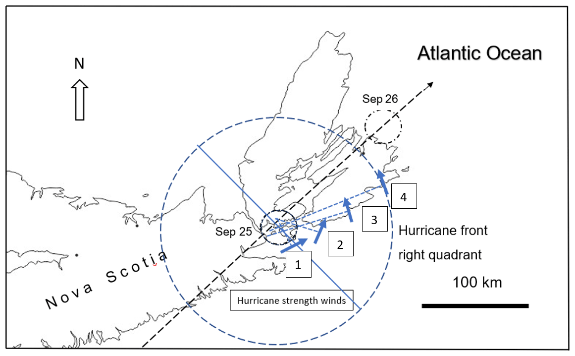
Figure 8Eye location and estimated translation speed. Plots of wind vectors on 25 September (08:00 LT) at (1) the Invincible, (2) the Windsor and Sunderland, (3) the Newark and most of the British fleet, and (4) the French ships at Louisbourg Harbour. Normal lines (dashed blue lines) taken to wind vectors cluster at the eye.
Modern analogues show strong similarities in significant and maximum wave height, but interpreted wind speeds for the Louisbourg storm are greater than those of Category 2 hurricane Juan, a winter extratropical “superbomb” in 2000, and the extratropical cyclone Fiona in 2022. Surge measured at three locations is consistent with the scale of surge from major hurricanes in the Gulf of Mexico and Caribbean. The 1757 surge greatly exceeds that of modern analogues that crossed the same bathymetry with similar translation speeds. This consistent basis of comparison of surge height, closely linked to storm intensity, shows the Louisbourg Storm had an intensity far beyond a Category 2 system and was equal to a major hurricane. Surge calculated independently for the lowest streets of the historic town of Louisbourg, Battery de la Grave and the Tilbury wreck at St. Esprit were also consistent. Even accommodating the tidal range at Louisbourg, the French battleship Le Tonnant drawing 25 ft being beached requires an exceptional surge. Unlike the modern analogues, storm surge at Louisbourg was 100 km from landfall (Fig. 8).
The climatology of tropical cyclones on North America's eastern seaboard renders the simple attribution of “tropical” vs. “extratropical” problematic. It is unlikely that a fully tropical system with wind speeds equal to a Category 4 hurricane struck Nova Scotia. Hart and Evans' (2001) climatology for North Atlantic extratropical transition of tropical cyclones showed that the expansion of baroclinic conditions known to trigger transition as cooling autumn continental temperatures expanding under prevailing westerlies meets north-tracking tropical cyclones that reach their highest latitudes by October when SSTs peak. Cheung and Chu (2023) modelled different concentrations of CO2 as a forcing mechanism behind future global warming. Their model outputs showed that more destructive extratropical cyclones originating in the tropics as tropical cyclones become more frequent in response to warming. The key factors in storm-destructive energy are increased wind speed and the expansion of the wind field during the extratropical transition. This supports the climatology of Hart and Evans (2001), who describe the collapse of the symmetric tropical wind field into an asymmetric extratropical storm during transition, and the tendency for tropical cyclones formed below 20° N to maintain their tropical integrity into higher latitudes where they have a higher probability of post-transition intensification. The National Hurricane Center (NHC) uses sea surface temperatures plus storm asymmetry in satellite images to gauge the degree of transition. Hart and Evans (2001) also found that “the NHC declaration (of extratropical transition) typically occurs early in the 1 to 2-day period … when the storm is just beginning to lose its tropical characteristics.” This is not easy to assess for the Louisbourg Storm, whose energy release may have occurred over a much shorter period. The eye symmetry at landfall on 25 September is based on the convergence of normal lines to vectors at ship locations (Fig. 8) suggesting it may have had largely tropical characteristics at landfall. It leads to the question at what point was it “tropical” (hurricane) vs. “extratropical” given the NHC's 1 to 2 d range. The storm's unusually large size is indicated by its winds first being recorded on 22 September by both the British and French fleets at Cape Breton on the same day it struck the British frigate Winchelsea off North Carolina, 1350 km to the southwest. This may have enabled it to continue to draw tropical energy from the Gulf Stream as it neared the Nova Scotia coastline. Hart and Evans's (2001) extratropical climatology shows that in some cases tropical cyclones can continue to intensify north of strongly baroclinic conditions that trigger transition, resulting in an explosive release of energy and post-transition intensification. Their analysis of past Atlantic hurricanes shows that the region most conducive to post-transition intensification in the North Atlantic basin lies immediately south of Cape Breton, Nova Scotia, which covers the track of the Louisbourg Storm in 1757.
Multidecadal climate trends for temperate North America show 18th century warming peaking mid-century, followed by cooling within a cooler mean temperature associated with the LIA (Trouet et al., 2013). This supports the early argument by Mann (2002), who argued that the LIA was a period of natural climate variability that is indicated by relatively warm summers offset by colder winters to provide cooler mean and multidecadal LIA temperature trends. Tropical cyclones continued to transfer equatorial heat northward into the midlatitudes where they likely encountered colder LIA continental temperatures earlier in hurricane season, driving a sharper temperature contrast and greater baroclinic instability, resulting in a more catastrophic energy release during extratropical transition. Oliva et al. (2018) noted the importance of various proxies to study historical Atlantic hurricanes given the importance of understanding their frequency and intensity as a benchmark against future storms. One area on the eastern seaboard of North America showing a notable data gap is Nova Scotia (Oliva et al., 2018). Not only has the population of the northeastern United States and Atlantic Canada grown since 1757, but coastal waters experienced massive shipping growth between North America and Europe. In addition, sea level rise since 1757 and projected rise increases storm surge risk to coastlines under more powerful storms. Hart and Evans (2001) identified this region as having the highest probability of post-transition intensification. Heightened temperature gradients into fall driven by warmer SSTs would not only fuel more powerful tropical cyclones reaching higher latitudes but more intense extratropical cyclones as well.
In 1757 a cold air mass met a hurricane that tracked north along the Gulf Stream from the coast of Florida. The resulting explosive release of energy was likely due to extratropical transition driven by the heightened temperature gradient between colder continental and tropical maritime circulation during the LIA, giving the Louisbourg Storm its destructive power. This increase in energy requires only an incremental change in the accepted climatology of Atlantic cyclone extratropical transition. The duration of hurricane force winds (15 h) over the coast may have been enhanced by the storm's large diameter, possibly a result of transition. The storm drove an unusually high surge at high tide. Warmer SSTs under anthropogenic forcing creating steeper autumn coastal temperature gradients could fuel future midlatitude tropical and extratropical cyclones of increasing destructive power.
Any data not presented in the paper can be made available upon reasonable request.
The supplement related to this article is available online at: https://doi.org/10.5194/cp-20-1141-2024-supplement.
Historical research and storm characterization was conducted by JD beginning in 1996. GW recognized the potential for publishing the study and provided in-kind scientific research support through the Basin and Reservoir Lab and constructive review during the preparation of the manuscript.
The contact author has declared that neither of the authors has any competing interests.
Publisher's note: Copernicus Publications remains neutral with regard to jurisdictional claims made in the text, published maps, institutional affiliations, or any other geographical representation in this paper. While Copernicus Publications makes every effort to include appropriate place names, the final responsibility lies with the authors.
The authors would like to thank William Pretel and Antoine LaChance for constructive review comments on the manuscript. Research assistance was provided by Cambria Huff (Dalhousie), John Allison (UK), the National Archives (UK), and the Public Archives of Nova Scotia. All figures were drafted by John Dickie. Tony Sampson, commercial diver, coordinated marine operations and underwater exploration along with John Dickie and Zodiac Divers Dave Murphy, Steve Jennex, Dana Sheppard, and Stephen Dugas.
This paper was edited by Pierre Francus and reviewed by Antoine Lachance and William Gomez Pretel.
ADM 1/481: Letters from Commanders in Chief North America 1755–1760 (Charles Holmes) The State and Condition of His Majesty's Ships and Sloops under my Command at New York between 3rd of May 1757 and 9th following, The National Archives, UK, https://discovery.nationalarchives.gov.uk/details/r/C4771564 (last access: 20 September 2021), 1757a.
ADM 1/481: Letters from Commanders in Chief North America 1755–1760 (Frances Holbourne) Newark at sea 28 September [Letter to the Admiralty outlining his squadron's inability to continue operations and the need to refit], The National Archives, UK, https://discovery.nationalarchives.gov.uk/details/r/C4771564 (last access: 20 September 2021), 1757b.
ADM 1/481: Letters from Commanders in Chief North America 1755–1760 (Frances Holbourne) Newark at sea 28 September [list of damage to ships sustained in the gale], The National Archives, UK, https://discovery.nationalarchives.gov.uk/details/r/C4771564 (last access: 20 September 2021), 1757c.
ADM 1/481: Letters from Commanders in Chief North America 1755–1760 (Frances Holbourne) Newark at Sea 30 September, The National Archives, UK, https://discovery.nationalarchives.gov.uk/details/r/C4771564 (last access: 20 September 2021), 1757d.
ADM 1/481: Letters from Commanders in Chief North America 1755–1760 Newark at Halifax 14 October [A letter from Frances Holbourne to the Admiralty outlining the state of the squadron and the enemy's ships at Louisbourg], The National Archives, UK, https://discovery.nationalarchives.gov.uk/details/r/C4771564 (last access: 20 September 2021), 1757e.
ADM 1/1488: Captain's Letters 1757 (Bently, Jonathon). An account of the damages received on board His Majesty's Ship Invincible in the hurricane on the 25th September, The National Archives, UK, https://discovery.nationalarchives.gov.uk/details/r/C4772571 (last access: 20 September 2021), 1757.
ADM 1/2294: Captain's Letters 1757 (Palliser, Hugh). Sunday 25th September 1757 at 2 a.m. An account of the Eagle's situation and of the damages she received in the late gale of wind, The National Archives, UK, https://discovery.nationalarchives.gov.uk/details/r/C4773376 (last access: 20 September 2021), 1757a.
ADM 1/2294: Captain's Letters 1757 (Palliser, Hugh). Eagle at sea 30 September, 1757. Account of the Condition of His Majesty's Ship Eagle, The National Archives, UK, https://discovery.nationalarchives.gov.uk/details/r/C4771564 (last access: 20 September 2021), 1757b.
ADM 8/31: Admiralty List Books 1756–1757 Halifax Station, The National Archives, UK, https://discovery.nationalarchives.gov.uk/details/r/C537622 (last access: 20 September 2021), 1757.
ADM 8/32: Admiralty List Books 1757–1758 Halifax Station, The National Archives, UK, https://discovery.nationalarchives.gov.uk/details/r/C537623 (last access: 20 September 2021), 1757.
ADM 51/409: Captain's Log HMS Grafton (1755 Feb 7–1764 Jun 24), The National Archives, UK, https://discovery.nationalarchives.gov.uk/details/r/C4460516 (last access: 20 September 2021), 1757.
ADM 51/471: Captain's Log HMS Invincible (1756 Aug 7–1758 Mar 6), The National Archives, UK, https://discovery.nationalarchives.gov.uk/details/r/C4460776 (last access: 20 September 2021), 1757.
ADM 51/633: Captain's Log HMS Newark (1755 Jul 31–1760 Apr 1), The National Archives, UK, https://discovery.nationalarchives.gov.uk/details/r/C4462295 (last access: 20 September 2021), 1757.
ADM 51/537: Captain's Log HMS Lightning (1755 Oct 14–1759 Jan 28), The National Archives, UK, https://discovery.nationalarchives.gov.uk/details/r/C4460956 (last access: 20 September 2021), 1757.
ADM 51/921: Captain's Log HMS Sunderland (1756 Nov 15–1759 Feb 23), The National Archives, UK, https://discovery.nationalarchives.gov.uk/details/r/C4462272 (last access: 20 September 2021), 1757.
ADM 51/1075: Captain's Log HMS Windsor (1755 Jun 12–1759 May 20), The National Archives, UK, https://discovery.nationalarchives.gov.uk/details/r/C4462763 (last access: 20 September 2021), 1757.
ADM 52/570: Master's Log HMS Devonshire (1757 May 31–1759 Dec 31) https://discovery.nationalarchives.gov.uk/details/r/C2531113 (last access: 20 September 2021), 1757.
ADM 52/578: Master's Log HMS Eagle (1757 Apr 28–1759 Mar 3), The National Archives, UK, https://discovery.nationalarchives.gov.uk/details/r/C2531251 (last access: 20 September 2021), 1757.
ADM 52/819: Master's Log HMS Captain (1756 May 21–1760 Feb 21), The National Archives, UK, https://discovery.nationalarchives.gov.uk/details/r/C2530393 (last access: 20 September 2021) 1757.
ADM 52/1105: Master's Log HMS Winchelsea (1755 Dec 29–1757 Dec 31), The National Archives, UK, https://discovery.nationalarchives.gov.uk/details/r/C253444 (last access: 20 September 2021), 1757.
ADM 52/1064: Master's Log HMS Terrible (1756 Feb 22–1758 Sep 30), The National Archives, UK, https://discovery.nationalarchives.gov.uk/details/r/C2534093 (last access: 20 September 2021), 1757.
Avila, L.: National Hurricane Center Tropical Cyclone Report – Hurricane Juan, 11 pp., https://www.nhc.noaa.gov/data/tcr/AL152003_Juan.pdf (last access: 2 April 2024), 2003.
Avila, L., Stewart, S., Berg, R., and Berg, A.: National Hurricane Center tropical Cyclone report-Hurricane Dorian, 74 pp., https://www.nhc.noaa.gov/data/tcr/AL052019_Dorian.pdf (last access: 2 April 2024), 2019.
Barriopedro, D., Gallego, D., Alvarez-Castro, C., García-Herrera, R., Wheeler, D., Pena-Ortiz, C., and Barbosa, S.: Witnessing North Atlantic westerlies variability from ships' logbooks (1685–2008), Clim. Dynam., 43, 939–955, https://doi.org/10.1007/s00382-013-1957-8, 2014.
Bertler, N., Mayewski, P., and Carter, L.: Cold conditions in Antarctica during the Little Ice Age-Implications for abrupt climate change mechanisms, Earth Planet. Sc. Lett., 308, 41–51, 2011.
Blake, N. and Lawrence, R.: The Illustrated Companion to Nelson's Navy, Chatham Publishing, UK, p. 144, ISBN 1-86176-090-6, 1999.
Boston News-letter: New Brunswick Historical Newspapers Project, https://newspapers.lib.unb.ca/node/800 (last access: 18 April 2024), 1757.
British High Commission: Letter advising the Minister of Foreign Affairs of the British Government's position respecting the sovereign protection of the HMS Fantome and HMS Tilbury shipwrecks, Canada Note 26-06, Ottawa, 2006.
Canadian Hydrographic Survey Chart 4375: Guyon Island to Flint Island, 1:75 733, https://charts.gc.ca/charts-cartes/charts-cartes-eng.asp?num=4375 (last access: 18 April 2024), 2002.
Chenowith, M.: Reassessment of Historical Atlantic Basin Tropical Cyclone Activity, 1700–1855, Climatic Change, 76, 169–240, 2006.
Cheung, H. and Chu, J.: Global increase in destructive potential of extratropical transition events in response to greenhouse warming, Clim. Atmos. Sci., 6, 1–10, https://doi.org/10.1038/s41612-023-00470-8, 2023.
Corbett, J.: England in the Seven Years' War: A Study in Combined Strategy, 2 Vols., Longmans, Green and Company, London, 407 pp., ISBN 0404092241, 1907.
Cornwall Council: Developing Magnetometer Techniques to Identify Submerged Archaeological Sites [data-set], York: Archaeology Data Service [distributor] https://doi.org/10.5284/1000130, 2010.
Cronin, T., Hayo, K., Thunell, R., Dwyer, G., Saenger, C., and Willard, D.: The medieval climate anomaly and Little Ice Age in Chesapeake Bay and the North Atlantic Ocean, Palaeogeogr. Palaeocl., 297, 299–310, 2010.
Day, J. and Hodges, K.: Growing land-sea temperature contrast and the intensification of Arctic cyclones, Geophys. Res. Lett., 45, 3673–3681, 2018.
Dezileau, L., Sabatier, P., Blanchemanche, P., Joly, B., Swingedouw, D., Cassou, C., Castaings, J., Martinez, P., and Von Grafenstein, U.: Intense storm activity during the Little Ice Age on the French Mediterranean coast, Palaeogeogr. Palaeocl., 299, 289–297, 2011.
Donnelly, J., Bryant, S., Butler, J., and Dowling, J.: 700 yr. sedimentary record of intense hurricane landfalls in Southern New England, Geol. Soc. Am. Bull., 113, 714–727, 2001.
Donnelly, R., Hawkes, A., Lane, P., Macdonald, D., Shuman, B., Van Hengstum, P., and Woodruff, J.: Climate forcing of unprecedented intense-hurricane activity in the last 2000 years, Earth's Future, 3, 49-65, https://doi.org/10.1002/2014EF000274, 2015.
Duggan, R.: Coastal Heritage Planning at the Fortress of Louisbourg – Planning it Out, in: Archaeology in Nova Scotia: 2010 News, Nova Scotia Museum Collections Unit, Halifax, 1–8, 2010.
Farley, F. (Ed.): Felix Farley's Bristol Journal, [Biweekly trade periodical] January 1–December 31, 1757, V. VI, Public Archives of Nova Scotia Collections, Mirofiche 8725, 1757.
Finck, P.: A Geological and Coastal Vulnerability Analysis of Point Michaud Provincial Park, Nova Scotia Natural Resources Open File Report ME 2015-003, Richmond County, Nova Scotia, 25 pp., https://www.novascotia.ca/natr/parks/management/point-michaud/pdf/pt-michaud-geological-coastal-analysis.pdf (last access: 19 April 2024), 2015.
Garcia, R. R., Diaz, R., Herrera, G., Eischeid, M., Prieto, E., Hernandez, L. Gimeno, F., Duran, R., and Bascary, A.: Atmospheric circulation changes in the tropical Pacific inferred from the voyages of the Manila Galleons in the sixteenth-eighteenth centuries, B. Am. Meteorol. Soc., 82, 2435–2455, 2001.
García-Herrera, R., Wilkenson, C. Koek, F., Prieto, M., Jones, P., and Koek, F.: Description and general background to ships' logbooks as a source of climatic data, Climatic Change, 73, 13–36, 2005a.
García-Herrera, R., Können, G., Wheeler, D., Prieto, M., Jones, P., sand Koek, F.: CLIWOC: a climatological database for the world's oceans 1750–1854, Climatic Change, 73, 1–12, 2005b.
Gebbie, G.: Atlantic warming since the Little Ice Age, Oceanography, 32, 220–230, 2019.
Gurgis, J. and Fowler, A.: A history of ENSO events since A.D. 1525: implications for future climate change, Climatic Change, 92, 343–387, 2009.
Hart, R. and Evans, J.: A climatology of the extratropical transition of Atlantic tropical cyclones, J. Climate, 14, 546–564, 2001.
Jackson, D., Costas, S., and Guisado-Pintado. E.: Large-scale transgressive coastal dune behaviour in Europe during the Little Ice Age, Global Planet. Change, 175, 82–91, 2019.
Jacoby, G. and D'Arrigo, R. Reconstructed Northern Hemisphere annual temperature since 1671 based on high-latitude tree-ring data from North America, Climatic Change, 14, 39–59, https://doi.org/10.1007/BF00140174, 1989.
Johnstone, J.: The campaign of Louisbourg, 1750-'58 [microform]: a short account of what passed at Cape Breton, from the beginning of the last war (1750) until the taking of Louisbourg, by the English, in the year of Our Lord, 1758, Memoirs of the Chevalier de Johnstone Vol. 3 of 3 [Translated in 1871 by Charles Winchester], 33 pp., 1758.
Jones, P. and Mann, M.: Climate over past millennia, American Geophysical Union, 42 pp., https://doi.org/10.1029/2003RG000143 2004.
Keigwin, L.: The Little Ice Age and medieval warming period in the Sargasso Sea, Science, 274, 1503–1508, 1996.
Keigwin, L., Sachs, J., and Rosenthal, Y.: A 1600-year history of the Labrador Current off Nova Scotia, Clim. Dynam., 21, 53–62, 2003.
Knabb, R., Rhone, J., and Brown, D.: Tropical cyclone report – Hurricane Katrina 23–30 August 2005, Tropical Cyclone Report, National Hurricane Center, 43 pp., https://nhc.noaa.gov/data/tcr/AL122005_katrina.pdf (last access: 30 September 2023), 2023.
Knox, J.: Historical journal of the campaigns in North America for the years 1757, 1758, 1759 and 1760, Volume 1 of 3, W. Johnston (Ludgate Street) and J. Dodsly (Pall Mall), London, 49 pp., 1769.
Kreutz, K., Mayewski, P., Meeker, L., Twickler, M., Whitlow, S., and Pittalwa, I.: Bipolar changes in atmospheric circulation during the Little Ice Age, Science, 277, 1294–1296, 1997.
Lady Anson: Letter of October 31, 1757 from Lady Anson to George Anson, First Lord of the Admiralty, British Museum Collections, London, UK, Add MSS 35, 376 p. 145, 1757.
Lalbeharry, R., Bigio, R., Thomas, B., and Wilson.: Numerical simulation of extreme waves during the storm of 20–22 January 2000 using winds generated by the CMC weather prediction model, Atmos. Ocean., 47, 99–122, 2009.
Lamb, H.: Climate, history, and the modern world, Methuen, New York, 387 pp., ISBN 0 416 33440 7, 1982.
Lamb, H.: Historical storms of the North Sea, British Isles and Northwest Europe, Cambridge University Press, London, 204 pp., ISBN 0 521 37522 3, 1991.
Landsea, C. Anderson, C., Charles, N., Dunion, J., Clark, G., Fernandez-Partagás, J., Hungerford, P., Neumann, C., and Zimmer, M.: The Atlantic hurricane database re-analysis project: Documentation for the 1851–1910 alterations and additions to the HURDAT database, in: Hurricanes and Typhoons: Past, Present, and Future, edited by: Murnane, R. J. and Liu, K.-B., Columbia University Press, 177–221, ISBN 9780231123884, 2004.
Lavery, B.: The Ship of the Line, in: Volume 1 – Development of the Battlefleet 1650–1850, Conway Maritime Press, London, 224 pp., ISBN 0851772528, 1983.
Lavery, B.: The Ship of the Line, in: Volume 2 – Design, Construction and Fittings, Conway Maritime Press, London, 191 pp., ISBN 0870219537, 1984.
Lavery, B.: The Royal Navy's First Invincible, Invincible Conservations Limited – Burgess and Son (Abingdon) Limited, Portsmouth, UK, 119 pp., ISBN 0715390287, 1988.
London Magazine: November, 563–564, 1758.
Ludlum, D.: Early American Hurricanes 1492–1870, American Meteorological Society, 191–192, https://babel.hathitrust.org/cgi/pt?id=mdp.39015002912718&seq=13 (last access: 19 April 2024), 1963.
Mann, M.: Little Ice Age, in: The Earth System: Physical and Chemical Dimensions of Global Environmental Change, Encyclopedia of Global Environmental Change, edited by: MacCracken, M. and Perry, S., Wiley and Sons Ltd., Chichester, UK, 504–509, ISBN 978-0-470-85360-3, 2002.
Matthes, F.: Report of Committee on Glaciers, April 1939, 20, Transactions, American Geophysical Union, 518–523, 1939.
Mazzarella, A. and Scafetta, N.: The Little Ice Age was 1.0–1.5 °C cooler than current warm period, Clim. Dynam., 51, 3957–3968, 2018.
McLennan, J.: Louisbourg from its foundation to its fall, (1969 Reprint), Fortress Press, Sydney, Nova Scotia, 207–210, ISBN 10 0969017707, 1918.
Miller, G., Geirsdóttir, Á., Zhong, Y., Larsen, D., Otto-Bliesner, B., Holland, M., Bailey, D., Refsnider, K., Lehman, S., Southon, J., Anderson, C., Björnsson, H., and Thordarson, T.: Abrupt onset of the Little Ice Age triggered by volcanism and sustained by sea-ice/ocean feedbacks, Geophys. Res. Lett. 39, L02708, https://doi.org/10.1029/2011GL050168, 2012.
Mowat, H.: A plan of the island of Cape Breton reduced from Captn [soundings and naval observations were taken by Lieut. Henry Mowat, commander of His Majesty's armed ship Canceaux and the officers of the ship under his direction], edited by: Holland, S., Holland's Survey, 1776.
Nature Notes: [European heat wave of 1757], 24 August 1882, p. 415, 1882.
Oliva, H., Peros, M., Viau, A., Reinhardt, E., Nixon, F., and Morin, A.: A multi-proxy reconstruction of tropical cyclone variability during the past 800 years from Robinson Lake, Nova Scotia, Canada, Mar. Geol., 406, 84–97, 2018.
Oliver, J. and Kington, J.: The usefulness of ships' log-books in the synoptic analysis of past climates, Weather, 25, 520–528, 1970.
Pasch, R., Berg. R., Roberts, D., and Papin, P.: National Hurricane Center Tropical Cyclone Report – Hurricane Laura (AL132020) August 20–29 2020, 75 pp., https://nhc.noaa.gov/data/tcr/ (last access: 30 September 2023), 2021.
Poey, A.: A chronological table, comprising 400 cyclonic hurricanes which have occurred in the West Indies in the North Atlantic within 362 years, from 1493 to 1855, J. Roy. Geogr. Soc., 25, 291–328, 1855.
Richey, J., Poore, R., Flower, Benjamin P., Quinn, T., and Hollander, D.: Regionally coherent Little Ice Age cooling in the Atlantic Warm Pool, Geophys. Res. Lett., 36, L21703, https://doi.org/10.1029/2009GL040445, 2009.
Ruffman, A.: The multidisciplinary rediscovery and tracking of `The Great Newfoundland and Saint-Pierre et Miquelon hurricane of 1775', in: Vol. 1, The Northern Mariner/Le Marin du Nord, 11–23, https://www.cnrs-scrn.org/northern_mariner/vol06/tnm_6_3_11-23.pdf (last access: 19 April 2024), 1996.
Saegaesser, L.: The U.S.S. Macedonian and the hurricane of 1818, Proceedings of the US Naval Institute, https://www.usni.org/magazines/proceedings/1970/january/uss-macedonian-and-hurricane-1818 (last access: 19 April 2024), 1970.
Saenger, C., Cohen, A., Oppo, D., Halley, R., and Carilli, J.: Surface-temperature trends and variability in the low-latitude North Atlantic since 1552, Nat. Geosci., 2, 492–495, 2009.
Sicre, M., Jalali, B., Martrat, B., Schmidt, S., Bassetti, M., and Kallel, N.: Sea surface temperature variability in the North Western Mediterranean Sea (Gulf of Lion) during the Common Era, Earth Planet. Sc. Lett., 456, 124–133, 2016.
Smyth, W.: The Sailor's Word-book: an alphabetical digest of nautical terms, including some more especially military and scientific … as well as archaisms of early voyagers, etc. by the late Admiral W. H. Smyth (2004 Reprint), Algrove Publishing Limited, Toronto, 744 pp., 1867.
Stoetzel, D.: Encyclopedia of the French and Indian War in North America, 1754–1763, Heritage Books, UK, 579 pp., ISBN 9780788445170, 2008.
Storm, A.: Seaweed and Gold, City Printers Limited, Sydney, Nova Scotia, 192 pp., ISBN 10 0973077204, 2002.
Studholme, J. Fedorov, A., Gulev, S. Emanuel, K., and Hodges, K.: Poleward expansion of tropical cyclone latitudes in warming climates, Nat. Geosci., 15, 14–18, https://doi.org/10.1038/s41561-021-00859-1, 2022.
Syrett, D.: Shipping and Military Power in the Seven Years' War, 1756–1763: The Sails of Victory, Liverpool University Press, UK, 192 pp., ISBN 13 978 0859897860, 2008.
The London Chronicle: July 23–26, 81–89, https://books.google.ca/books?id=U-_lAAAAMAAJ&pg=PA88&redir_esc=y#v=onepage&q&f=false (last access: 20 April 2021), 1757.
Trouet, V., Scourse, J., and Raible C.: North Atlantic storminess and Atlantic meridional overturning circulation during the last millennium: reconciling contradictory proxy records of NAO variability, Global Planet. Change, 84–85, 48–55, 2012.
Trouet, V., Diaz, H., Wahl, E., Viau, H., Graham, R., Graham, N., and Cook, E.: A 1500-year reconstruction of annual mean temperature for temperate North America on decadal to multi-decadal timescales, Environ. Res. Lett., 8, 024008, https://doi.org/10.1088/1748-9326/8/2/024008, 2013.
US Department of Commerce Environmental Science Services Administration Weather Bureau: Tropical Cyclone Report – Hurricane Camille August 14–22, 1969, 58 pp., https://www.nhc.noaa.gov/pdf/TCR-1969Camille.pdf (last access: 19 April 2024), 1969.
Van Vliet-Lanoë, B., Goslin, J., Hallégouët, B., Hénaff, A., Delacourt, C., Fernane, A., Franzetti, M., Le Cornec, E., Le Roy, P., and Penaud, A.: Middle- to late-Holocene storminess in Brittany (NW France): Part I – morphological impact and stratigraphical record, Holocene, 24, 413–433, 2014.
Vecchi, G. and Knutson, T.: On estimates of historical North Atlantic tropical cyclone activity, J. Climate, 21, 3580–3600, 2008.
Virot, E., Ponomarenko, A., Dehandschoewercker, E., Quere, D., and Clanet, C.: Critical wind speed at which trees break, Phys. Rev., 94, 059907, https://doi.org/10.1103/PhysRevE.94.059907, 2016.
Warden, D.: A statistical, political, and historical account of the United States of North America from the period of their first colonization to the present day, Vol. 1 of 3, p. 155, https://archive.org/details/statpolhistacc01wardrich/page/154/mode/2up (last access: 19 April 2024), 1819.
World Geodetic System: National Geospatial Intelligence Agencu, WGS 84 (G1674), https://www.unoosa.org/pdf/icg/2012/template/WGS_84.pdf#:~:text=WGS 84 is the standard U.S. Department of,compatible with the International Terrestrial Reference System %28ITRS%29 (last access: 7 May 2024, 1984.
Wheeler, D.: The Great Storm of November 1703 – A new look at the seamen's records, Weather, 58, 419–427, 2003.
Wheeler, D.: An examination of the accuracy and consistency of ships' logbook weather observations and records, Climate Change, 31, 97–116, 2005.
Wheeler, D. and Wilkinson, C.: From calm to storm: the origins of the Beaufort Wind Scale, The Mariner's Mirror, 90, 187–201, https://doi.org/10.1080/00253359.2004.10656896, 2004.
Wheeler, D., Garcia-Herrera, R., and Wilkinson, C.: Atmospheric circulation and storminess derived from Royal Navy logbooks: 1685 to 1750, Climatic Change, 101, 257–280, 2010.
Winter, A., Ishioroshi, H., Watanabe, T., Oda, T., and Christy, J.: Caribbean sea surface temperatures' two-to-three degrees cooler than present during the Little Ice Age, Geophys. Res. Lett., 27, 3365–3368, 2000.
Zinck, J.: Shipwrecks of Nova Scotia, Lancelot Press, Nova Scotia Canada, 226 pp., ISBN 9780889990760, 1975.